Three-dimensional spatial data adaptive cache management method and system based on Hash table

A three-dimensional space and buffer management technology, applied in the direction of electrical digital data processing, special data processing applications, instruments, etc., can solve problems such as limited versatility, achieve integrated organization, meet the needs of efficient data scheduling, and shorten data search time Effect

Inactive Publication Date: 2010-12-15
CHINA UNIV OF GEOSCIENCES (WUHAN)
View PDF2 Cites 39 Cited by
  • Summary
  • Abstract
  • Description
  • Claims
  • Application Information

AI Technical Summary

Problems solved by technology

Because cache replacement algorithms based on special application strategies, such as DBMIN and Application-Controlled Fil

Method used


Image

  • Three-dimensional spatial data adaptive cache management method and system based on Hash table
  • Three-dimensional spatial data adaptive cache management method and system based on Hash table
  • Three-dimensional spatial data adaptive cache management method and system based on Hash table

Examples


Embodiment Construction

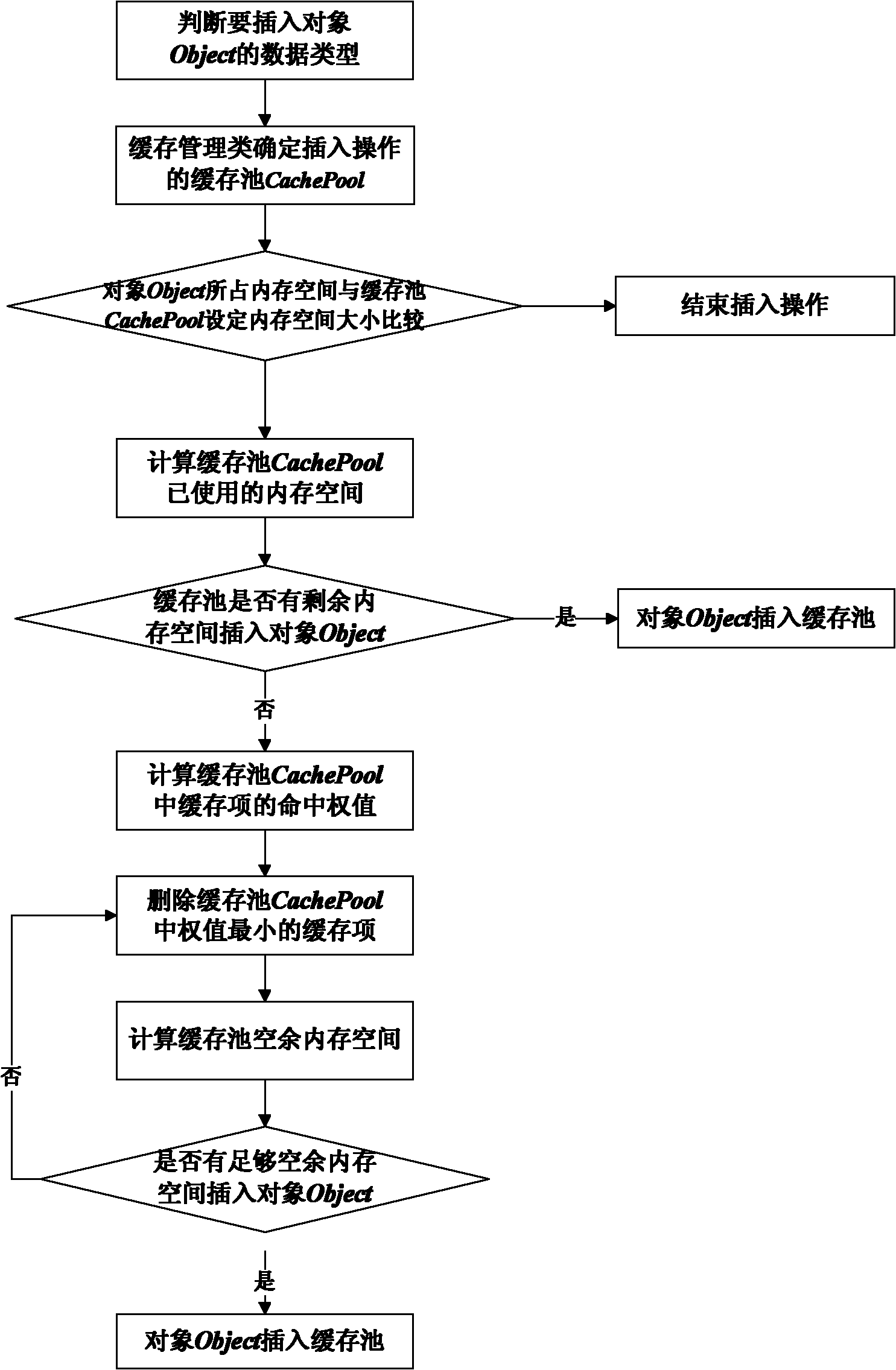
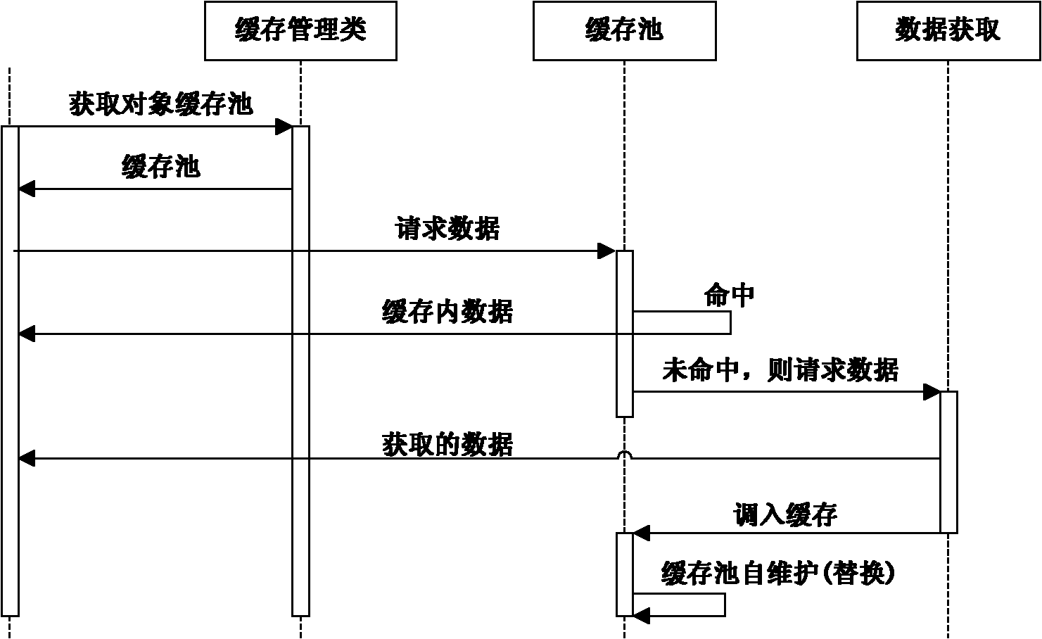
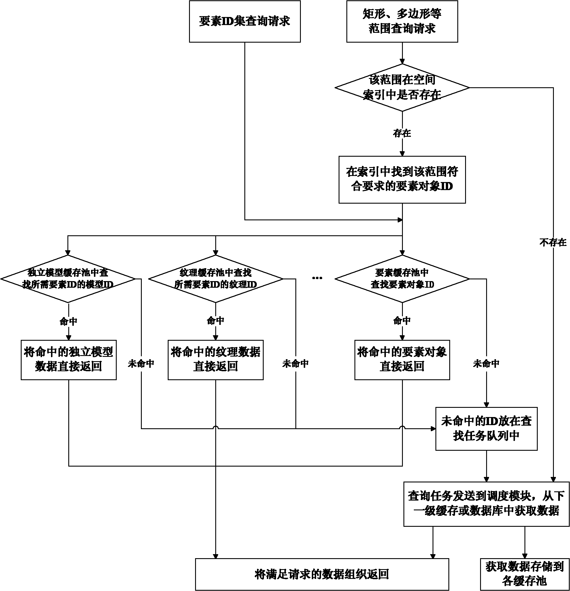
[0063] Below in conjunction with accompanying drawing, the present invention will be further described with specific implementation example:

[0064] The three-dimensional spatial data self-adaptive cache management system based on the hash table proposed by the present invention starts with the idea of ​​object-oriented, uses the database operation statistics combined with the system resource usage for adaptive adjustment, and is suitable for three-dimensional data based on the hash table storage. The cache management system of spatial data, the composition and implementation of this system will be described in detail below in conjunction with the accompanying drawings:

[0065] An adaptive cache management system for 3D spatial data based on hash tables, including four modules: a replacement module for comprehensive database operation information, an object-oriented cache pool management module, a 3D spatial object association query module, and a query based on data objects a...


PUM


Abstract

The invention relates to the technical field of spatial information management, in particular to a three-dimensional spatial data adaptive cache management method and system based on a Hash table. The invention adopts the object-oriented thought, combines the database run statistics analysis result and the computer system resource use conditions for cache adaptation adjustment and uses an object cache pool based on the Hash table for data storage management. The cache management method integrates the actual database run condition, equipment hardware information and object schedule information, sets the cache and the cache pool, carries out adaptive adjustment on the replacement algorithm function, improves the inquiry hit efficiency, organizes the scheduled objects in the cache pool based on the storage structure of the Hash table through object relation inquiry and shortens the object inquiry and organization time. The cache management method has high efficiency and can reduce system resource plunder, effectively solve the problem that the object model can not be dynamically organized and unitedly scheduled and be popularized and used in multiple object-oriented spatial data management software.

Description

technical field [0001] The invention relates to the technical field of spatial information management, in particular to a method and system for self-adaptive cache management of three-dimensional spatial data based on a hash table. Background technique [0002] Since 3D spatial data has the characteristics of complex structure, various types, huge data volume, unbalanced spatial distribution, individual object differences, and multi-level of detail expression, how to efficiently and integrate the data scheduling requirements for 3D real-time visualization applications Organizing, managing, and dispatching unevenly distributed above-ground, underground, outdoor, and indoor three-dimensional spatial data has become a difficult point that needs to be overcome urgently. At the same time, the integrated storage and access of information related to geographic and geological features is a key technology for the development of GIS software platforms. [0003] Cache (Cache) is a ver...

Claims


Application Information

Patent Timeline
IPC IPC(8): G06F17/30
Inventor 何珍文吴冲龙刘刚翁正平王玭茜孙卡田宜平张夏林刘军旗陈巍刘圆圆李晶崔运涛何世波李莹莹
Owner CHINA UNIV OF GEOSCIENCES (WUHAN)
Why Eureka
Try Eureka