Method for assimilating remote sensing data of soil humidity in watershed scale

A soil moisture and remote sensing data technology, applied in electrical digital data processing, special data processing applications, instruments, etc., can solve problems such as error-prone, non-existent, and time-consuming solution of tangential adjoint equations of forecast models.

Inactive Publication Date: 2011-04-27
NANJING UNIV
View PDF3 Cites 66 Cited by
  • Summary
  • Abstract
  • Description
  • Claims
  • Application Information

AI Technical Summary

Problems solved by technology

However, the variational assimilation method also has some obvious defects. For example, the solution of the tangent linear adjoint equation necessary for this method is very time-consuming and error-prone, and even does...

Method used


Image

  • Method for assimilating remote sensing data of soil humidity in watershed scale
  • Method for assimilating remote sensing data of soil humidity in watershed scale
  • Method for assimilating remote sensing data of soil humidity in watershed scale

Examples


Embodiment

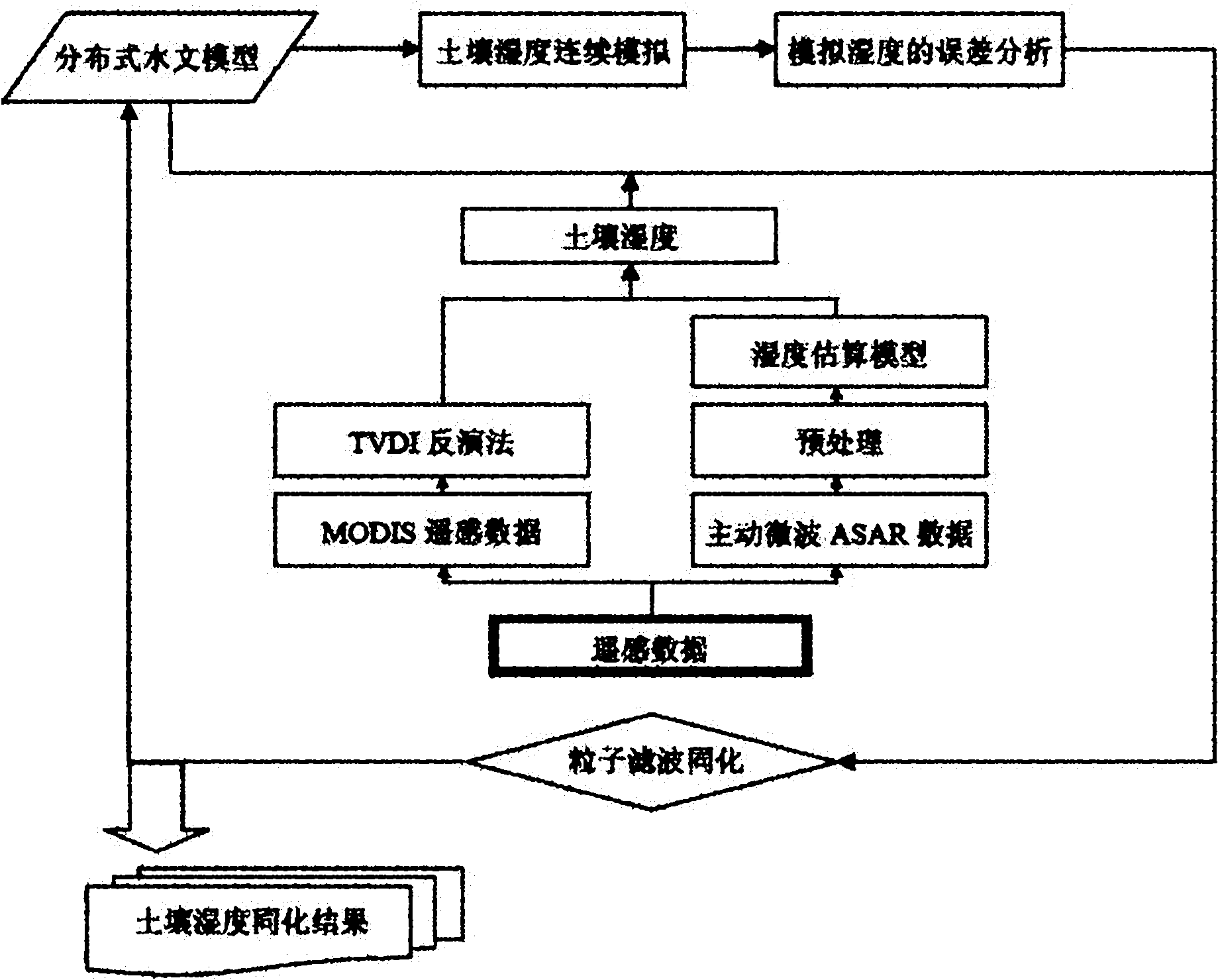
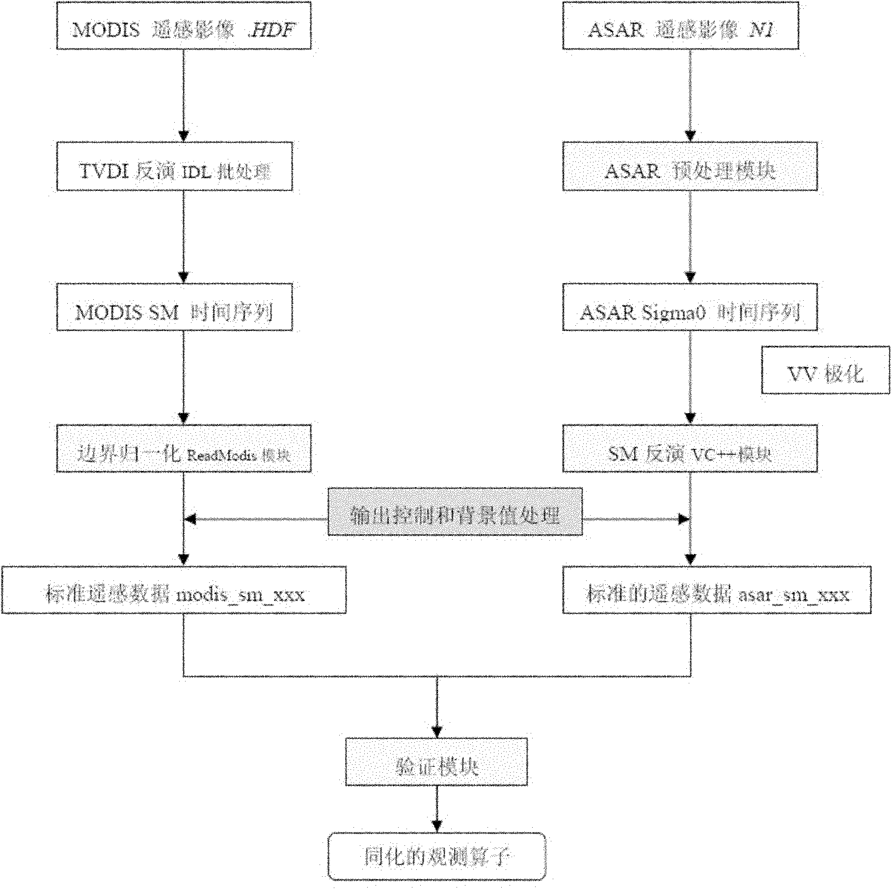
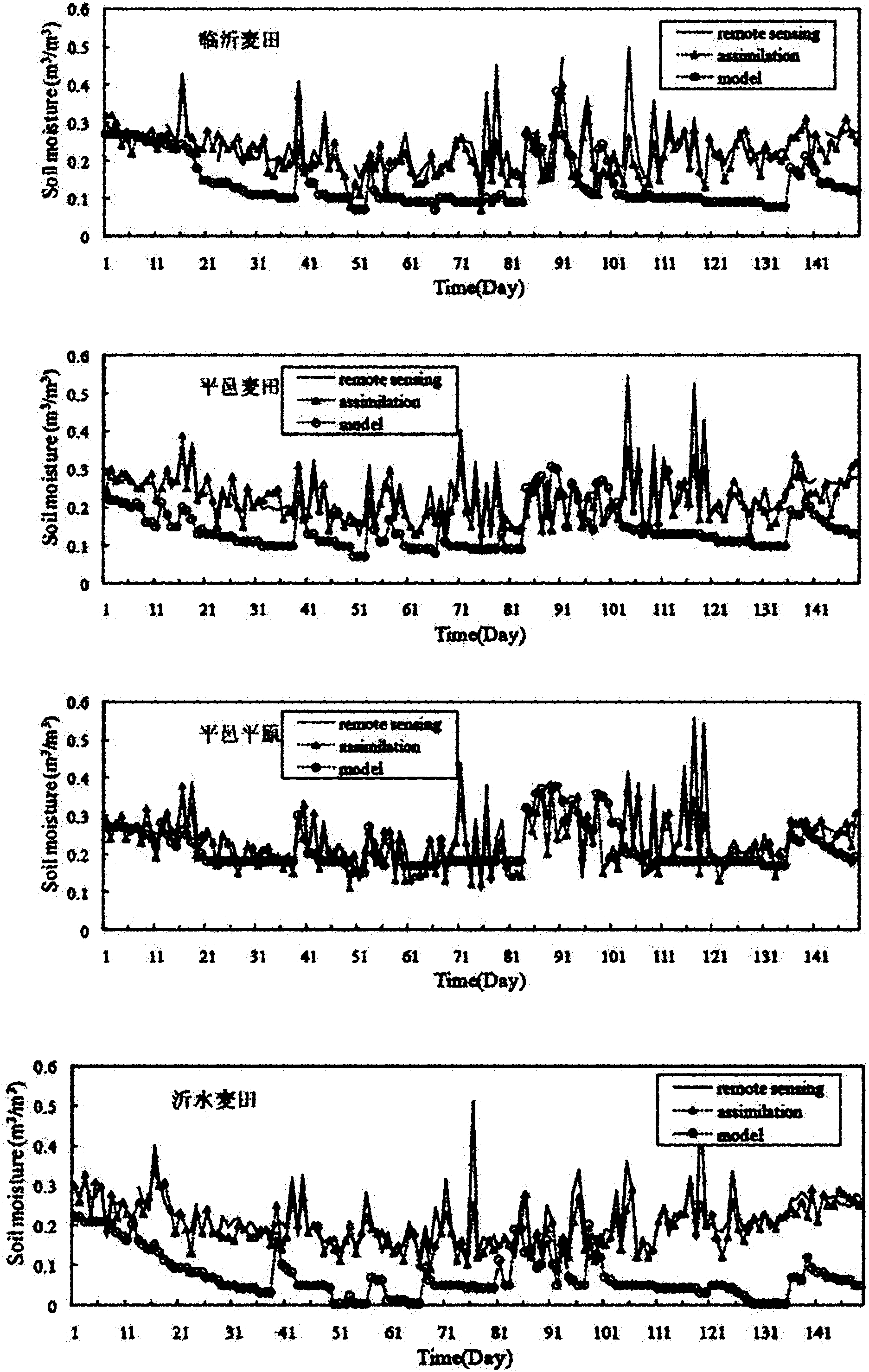
[0171] In order to obtain more accurate watershed surface soil moisture data, combining the advantages of model simulation and remote sensing data inversion, a watershed soil moisture assimilation scheme was established with the Yi River Basin as the research area. On the basis of using the established distributed watershed hydrological simulation platform to simulate the spatial and temporal dynamics of soil moisture in the study area in 2006, combined with the particle filter sequential assimilation algorithm, considering the errors of simulation and remote sensing inversion, assimilating the active microwave ENVISAT-ASAR Surface soil moisture information retrieved from MODIS visible light images. The updated watershed soil moisture assimilation data obtained in the sequential assimilation is fed back to the distributed hydrological model platform, and through recursive simulation, a physically consistent watershed surface soil moisture assimilation space-time data set is fin...


PUM


Abstract

The invention provides a method for assimilating remote sensing data of soil humidity in a watershed scale. The method comprises the following steps of: improving a watershed runoff producing calculation module and developing a distributed hydrological model which is suitable for assimilating remote sensing soil humidity information and describes a soil hydrodynamic process; introducing a particle filtering sequence data assimilation method of information science, and continuously merging and assimilating new remote sensing observation data in a dynamic operation process of distributed hydrological process numerical simulation so as to acquire updated watershed soil humidity assimilated data during sequential assimilation; feeding the updated watershed soil humidity assimilated data back to a distributed hydrological model platform; and gradually estimating the time and space distribution pattern of watershed soil moisture content. Practices prove that by the method, not only high-precision and physically consistent watershed soil humidity data can be provided for research on hydrology, zoology, environment and agriculture, but also the foundation is laid for performing four-dimensional data assimilation processing on soil humidity data of an upper soil layer acquired by using remote sensing retrieval, and improving the precision of the model.

Description

technical field [0001] The invention relates to a method for assimilating remote sensing data, more specifically a method for assimilating remote sensing data of soil moisture at the watershed scale. Background technique [0002] The state of soil moisture is not only the final result of the evolution of the climate and water resources system, but also exerts a strong feedback on the climate and soil vegetation atmospheric interaction system, which will profoundly affect its future changes. In the field of hydrology and water resources, obtaining accurate spatial distribution of soil moisture can be used as the initial value of soil moisture for flood simulation of hydrological models, improving the accuracy of flood forecasting. At the same time, the corrected continuous and accurate soil moisture data has potential application value for long-term hydrological process simulation, runoff forecasting and forecasting changes in water resources. Develop a distributed hydrologi...

Claims


Application Information

Patent Timeline
IPC IPC(8): G06F19/00
Inventor 张万昌陈炯峰
Owner NANJING UNIV
Why Eureka
Try Eureka