Inversion method for land aerosols optical thickness based on environment satellite 1

An optical thickness and aerosol technology, applied in the field of atmospheric remote sensing, can solve the problems of high requirements, increased cost, and complicated acquisition of short-wave infrared band data.

Inactive Publication Date: 2011-06-22
SATELLITE ENVIRONMENT CENT MINIST OF ENVIRONMENTAL PROTECTION
View PDF2 Cites 39 Cited by
  • Summary
  • Abstract
  • Description
  • Claims
  • Application Information

AI Technical Summary

Problems solved by technology

[0003] The current satellite remote sensing terrestrial aerosol inversion algorithms are mostly dark target algorithms. This method mostly uses short-wave infrared bands to identify dark targets and obtain surface reflectance to obtain aerosols. Ho

Method used


Image

  • Inversion method for land aerosols optical thickness based on environment satellite 1
  • Inversion method for land aerosols optical thickness based on environment satellite 1
  • Inversion method for land aerosols optical thickness based on environment satellite 1

Examples


Embodiment Construction

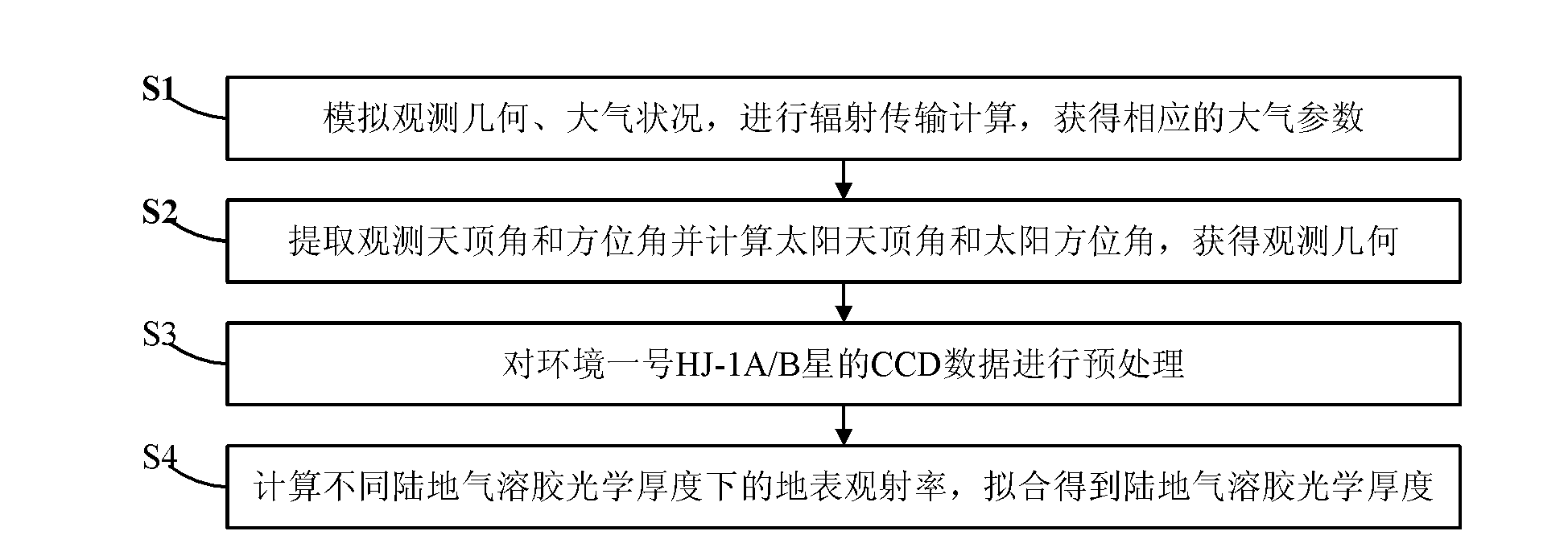
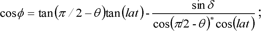
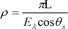
[0046] The terrestrial aerosol optical depth inversion method based on the Environment-1 satellite proposed by the present invention is described in detail in conjunction with the accompanying drawings and embodiments as follows.

[0047] HJ-1A / B is my country's environmental and disaster monitoring and forecasting small satellite constellation system, which has the characteristics of high spatial and temporal resolution and wide coverage. An important data source for the department's daily business. The environment and disaster reduction application system based on environmental satellite data has an important demonstration role in promoting remote sensing satellite business services, and provides a new remote sensing platform for remote sensing monitoring of ambient air quality in my country. Method of the present invention is mainly based on China Environment No. 1 A / B star (collectively referred to as HJ-1A / B star in this application) CCD data, utilizes HJ-1A / B star CCD dat...


PUM


Abstract

The invention discloses an inversion method for land aerosols optical thickness based on the environment satellite 1. The method comprises the following steps of: S1, simulating and observing geometric atmospheric conditions, conducting radiation transfer calculation to obtain atmospheric parameters, and forming a lookup table; S2, according to auxiliary data, extracting the observed zenith angleand azimuth angle of each pixel, calculating solar zenith angle and azimuth angle, and obtaining observation geometry; S3, preprocessing CCD (Charge Coupled Device) data of a satellite HJ-1A/B; S4, obtaining the land surface reflectance information of each waveband by utilizing a dark target algorithm, interpolating the lookup table into the observation geometry of each pixel, calculating the land surface reflectance under different land aerosols optical thickness according to the obtained apparent reflectance after preprocessing, and then fitting to obtain the land aerosols optical thickness. The method can be used for quickly and conveniently realizizng land aerosols monitoring on a large scale and providing a data source for particulate pollution monitoring.

Description

technical field [0001] The invention relates to the technical field of atmospheric remote sensing, in particular to a land aerosol optical depth inversion method based on the Environment-1 satellite. Background technique [0002] The study of satellite remote sensing aerosols began in the mid-1970s. In the last 30 years of the last century, the satellite remote sensing aerosols used for research and operational use included volcanic eruption aerosol monitoring, NOAA, the United States National Oceanic and Atmospheric Administration) series satellites remote sensing of optical depth of aerosol layer caused by dust storms and forest fires over the deep sea, infrared remote sensing of dust aerosol remote sensing, TOMS remote sensing of absorbing aerosol in ultraviolet band, etc. The Moderate Resolution Imaging Spectrometer (MODIS) carried by Terra and Aqua of the US Earth Observing System Program (EOS) released the global distribution products of 10 km aerosol optical depth to ...

Claims


Application Information

Patent Timeline
IPC IPC(8): G01S7/48G01S17/08
Inventor 王桥王中挺厉青周春艳张丽娟王子峰毛慧琴杨幸陈辉黄陆雄段文举
Owner SATELLITE ENVIRONMENT CENT MINIST OF ENVIRONMENTAL PROTECTION
Why Eureka
Try Eureka