Unmanned plane route planning method based on SAR radar imaging

A radar imaging and unmanned aerial vehicle technology, applied in three-dimensional position/channel control and other directions, can solve problems such as error-prone, inability to work, flight safety hazards, etc., to improve the ability of wind changes, improve the efficiency of task completion, and save flight. effect of time

Inactive Publication Date: 2012-03-28
BEIHANG UNIV
View PDF0 Cites 3 Cited by
  • Summary
  • Abstract
  • Description
  • Claims
  • Application Information

AI Technical Summary

Problems solved by technology

If the airspeed and groundspeed of the UAV are coincident under calm wind conditions, and the nose of the UAV is pointing in the direction of the route, the SAR radar can work normally. figure 1 As shown, at this time, this group of routes can meet the requirements of the SAR radar imaging UAV to perform tasks on the imaging target area; High control, there is no problem with the stability of the pitch angle, and there is no problem with the roll angle range of the stable platform. Windward effect, the aircraft flies along the route, but its nose will deviate from the predetermined track direction, the greater the wind, the greater the deviation of the nose from the track, such as figure 2 As shown, due to the existence of the south wind, there is an angle between the airspeed and the ground speed, that is, the angle at which the nose deviates from the track, also known as the drift angle. When the drift angle exceeds the azimuth working range of the SAR radar stabilization platform , the SAR radar cannot perform normal imaging and cannot work normally. At this time, this group of routes can no longer meet the requirements of SAR radar imaging.
[0007] One solution is to obtain the meteorological data of the wind speed and wind direction distribution at the cruising altitude during the mission period in advance, so that a group of routes suitable for the wind in the air can be pre-planned according to the wind speed and wind direction, and the drift angle can be reduced to avoid this problem. The premise of this method is that very accurate weather data can be obtained before the flight. If the weather data is not available or the weather forecast is wrong, this method will be meaningless; another method is to discover the planned route. When the requirements cannot be met, the route planners plan another group of routes in real time that can adapt to the current wind speed and direction. This method requires the UAV to have the function of real-time route planning. In addition, due to the imaging characteristics of SAR radar, the planned routes are all There are many parallel routes, and the amount of waypoint data is large, so the workload of planning is also large, which is not only time-consuming, but also prone to errors in highly stressful situations, which brings hidden dangers to flight safety

Method used


Image

  • Unmanned plane route planning method based on SAR radar imaging
  • Unmanned plane route planning method based on SAR radar imaging
  • Unmanned plane route planning method based on SAR radar imaging

Examples


Embodiment

[0052] The route planning method provided by the present invention will be further described below through specific examples and data.

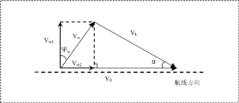
[0053] The present invention is applied to the route planning of a certain type of unmanned aerial vehicle. The azimuth working range of the SAR radar stabilization platform loaded on the unmanned aerial vehicle is ±22°, that is, β=22°, and the flight height of a certain imaging task is 4000m , the airspeed is 40m / s, and the concrete steps of realizing the present invention are:

[0054] Step 1: Preliminary determination of wind speed and direction;

[0055] At that time, due to the limitation of the meteorological department of the airport, the wind data at the height of 4000m could not be obtained. The forecast of the meteorological department was: the wind speed at the height of 3000m was 25m / s, and the wind direction was 138°. There is some change, but the wind speed does not change much; according to the forecast, the wind speed at the ...


PUM


Abstract

The invention discloses an unmanned plane route planning method based on SAR (Synthetic Aperture Radar) radar imaging, which is used for solving the problem that data of the wind in the air cannot be accurately obtained, the variation of the wind causes that a drift angle of the unmanned plane exceeds limit of an operating angle range in the direction of a SAR radar stable platform, and the radarimaging is influenced. With the method provided by the invention, according to primary wind speed and wind direction data, the minimum number of planning routes is determined based on a relation among the airspeed, the ground speed and the wind, and a working range in the direction of the stable platform, so that the aim of planning a plurality of groups of effective standby routes in advance is implemented; moreover, by the method, capability of the unmanned plane to deal with the variation of the wind in the air can be improved, probability of being prone to making mistakes caused temporarily planning large amount of routes is avoided, flight safety is improved, and simultaneously flight time is saved and efficiency of finishing tasks is improved.

Description

technical field [0001] The invention belongs to the field of unmanned aerial vehicle navigation guidance and control, and specifically refers to an unmanned aerial vehicle route planning method for SAR radar imaging applied to unmanned aerial vehicles. Background technique [0002] Airborne Synthetic Aperture Radar (SAR) is an advanced radar detection system developed in the late 1960s. Airborne synthetic aperture radar can not only provide a wide surveillance airspace, ultra-high resolution and automatic target tracking capabilities, but also provide imaging and maps similar to photos. [0003] The reason why synthetic aperture radar has received great attention from domestic and foreign radar circles is that its resolution is beyond the reach of ordinary image radar under the same conditions. The resolution of SAR is not much different from that of visible light, but it has many important advantages over visible light photography. First of all, SAR signals can be transmi...

Claims


Application Information

Patent Timeline
Patent Type & Authority Patents(China)
IPC IPC(8): G05D1/10
Inventor 张翠萍王宏伦向锦武郑丽丽
Owner BEIHANG UNIV
Why Eureka
Try Eureka