Radar scene matching feature reference map preparation method based on satellite SAR (synthetic aperture radar) images

A scene matching, reference map technology, applied in the direction of reflection/re-radiation of radio waves, instruments, measuring devices, etc., to achieve the effect of real-time map matching, accuracy and reliability improvement

Inactive Publication Date: 2011-09-07
HUAZHONG UNIV OF SCI & TECH
View PDF1 Cites 13 Cited by
  • Summary
  • Abstract
  • Description
  • Claims
  • Application Information

AI Technical Summary

Problems solved by technology

In recent years, the launch of synthetic aperture radar imaging satellites has provided a data basis for the preparation of ra

Method used


Image

  • Radar scene matching feature reference map preparation method based on satellite SAR (synthetic aperture radar) images
  • Radar scene matching feature reference map preparation method based on satellite SAR (synthetic aperture radar) images
  • Radar scene matching feature reference map preparation method based on satellite SAR (synthetic aperture radar) images

Examples


Embodiment Construction

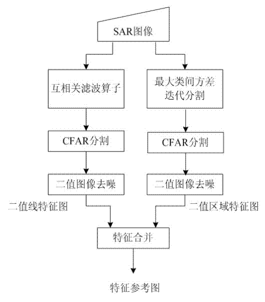
[0023] Combined with the RadarSat satellite's DBS radar image in the Hanzhong area, the process of the invention is used to realize the preparation of the radar matching feature reference map.

[0024] The concrete implementation process of the present invention is:

[0025] (1) Extract line features from ortho-SAR images.

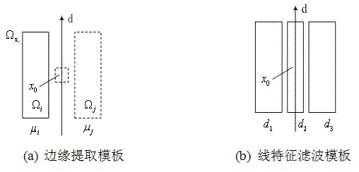
[0026] In the line feature extraction link, the present invention selects a line feature extraction algorithm based on a nonlinear cross-correlation filter operator. The algorithm first performs high-pass filtering on the SAR image, and then uses the nonlinear cross-correlation (CR) operator to enhance the dark line features, and then performs constant false alarm rate (CFAR) segmentation on the gray line feature map to obtain a binary image. Value image denoising, get binary line feature map. Specifically:

[0027] (11) High-pass filter

[0028] The purpose of using high-pass filtering in the process of extracting line features from SAR images is to s...


PUM


Abstract

The invention provides a radar scene matching feature reference map preparation method based on satellite SAR (synthetic aperture radar) images. The method comprises the following steps: respectively extracting line features and region features from an orthographic SAR image to obtain a binary line feature map and a binary region feature map; and combining the two feature maps to obtain the radar scene matching feature reference map. The method for preparing the radar matching feature reference map based on the SAR images has a good effect, small calculation amount, good real-time performance and low information assurance requirements, and can be effectively applied in the radar matching reference map preparation field.

Description

technical field [0001] The invention belongs to the field of radar image processing, in particular to a method for preparing a radar scene matching feature reference map based on satellite synthetic aperture imaging (SAR). Background technique [0002] The terminal guidance systems of advanced aircraft all use images from different sensors for matching guidance. In this process, the reference map is critical, which provides a common reference or coordinate system that specifies the current position and destination of the aircraft. [0003] In terms of data acquisition and guarantee, countries such as the United States and Europe have established spaceborne SAR sensor systems, which can obtain satellite radar image data of areas of interest in real time or quasi-real time. When necessary, airborne synthetic aperture radar imaging can also be used to obtain data conveniently. Foreign countries have accumulated a large amount of original data through years of measurement and r...

Claims


Application Information

Patent Timeline
IPC IPC(8): G01S7/02G01S13/90G06K9/46
Inventor 杨卫东孙向东张天序刘瑞涛武斌刘建华吴洋
Owner HUAZHONG UNIV OF SCI & TECH
Why Eureka
Try Eureka