Method for obtaining leaf area index based on quantitative fusion and inversion of multi-angle and multi-spectral remote sensing data

A technology of leaf area index and remote sensing data, which can be applied to measurement devices, optical devices, and re-radiation of electromagnetic waves. It can solve problems such as multiple sensors and achieve the effect of reducing errors.

Inactive Publication Date: 2012-01-11
INST OF GEOGRAPHICAL SCI & NATURAL RESOURCE RES CAS
View PDF0 Cites 35 Cited by
  • Summary
  • Abstract
  • Description
  • Claims
  • Application Information

AI Technical Summary

Problems solved by technology

It is almost impossible to solve these problems with a single sensor, and it is possible to solve the problem of multiple sensors if two different types of remote sensing data can be combined

Method used


Image

  • Method for obtaining leaf area index based on quantitative fusion and inversion of multi-angle and multi-spectral remote sensing data
  • Method for obtaining leaf area index based on quantitative fusion and inversion of multi-angle and multi-spectral remote sensing data
  • Method for obtaining leaf area index based on quantitative fusion and inversion of multi-angle and multi-spectral remote sensing data

Examples


Embodiment Construction

[0036] The present invention will be described in further detail below in conjunction with the accompanying drawings.

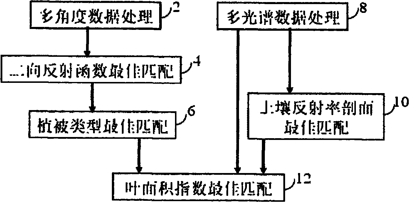
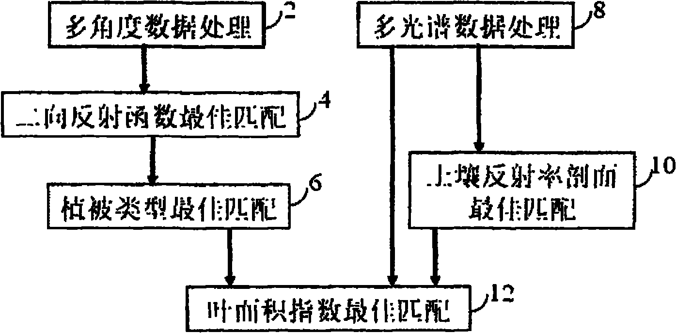
[0037] The flow chart of the multi-angle and multi-spectral remote sensing data quantitative fusion inversion leaf area index realized by the present invention is as follows figure 1 shown. figure 1 Including multi-angle data processing unit 2, bidirectional reflectance function model best matching unit 4, vegetation type best matching unit 6, multispectral data processing unit 8, soil reflectance profile best matching unit 10 and leaf area index best matching unit Unit 12.

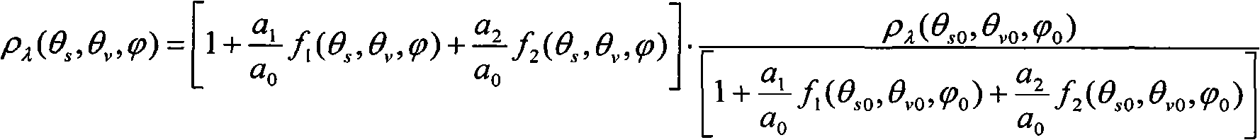
[0038] Unit 2 converts multi-angle sensor data from different sources into data with consistent specifications, including converting the coordinates of the data into coordinates consistent with the spatial projection coordinates of multispectral data through coordinate transformation, converting image count values ​​or radiation values ​​into surface reflectance , each observation angl...


PUM


Abstract

The invention provides a method for obtaining a leaf area index based on quantitative fusion and inversion of multi-angle remote sensing data and multi-spectral remote sensing data, which is characterized in that a coefficient of a bidirectional reflectance distribution function (BRDF) of a vegetation type of the best matching pixel level of the multi-angle remote sensing data and a surface reflectivity is adopted, a surface soil reflectivity profile is obtained based on best matching of the multi-spectral data, and a canopy radiation transmission model is driven to obtain the leaf area index with high accuracy and large-scope coverage based on the multi-spectral data. The invention has the advantages that: the ranges of wave bands of the multi-angle data and the multi-spectral data need not to be overlapped, and approximate treatment can be carried out by adopting the similarity of the bidirectional function of the available wave bands; the coefficient of the bidirectional reflectance function and the best matching vegetation type obtained based on the multi-angle data is relatively stable along with changes in the time and the space, time sequence data can be made into a background library to be used as input for inversion of the multi-spectral data, and thus the large-scale leaf area index with high time resolution can be obtained; and the best matching surface soil reflectivity profile obtained based on the multi-spectral data is relatively stable, and historical time sequence data can also be made into a background library. The method can be applied in crop growth monitoring, rapid estimation of crop yields and the like.

Description

technical field [0001] The invention belongs to the field of remote sensing digital image processing and quantitative data fusion. The invention is a method for realizing the quantitative fusion of multi-angle remote sensing data and multi-spectral remote sensing data to invert the leaf area index, in particular, using the multi-angle remote sensing data for optimal matching and automatically selecting a leaf area index inversion lookup table for a suitable vegetation type, Obtain the bidirectional reflectance function (BRDF) coefficient of the surface albedo at the pixel level; use multispectral data to obtain angle observation data with a wider coverage, and obtain information such as the surface soil albedo profile, chlorophyll and leaf water content, and combine the two , a method to drive canopy radiative transfer models to obtain leaf area indices with high accuracy and wide coverage. The invention can be used in the fields of crop growth monitoring, fast estimation of ...

Claims


Application Information

Patent Timeline
Patent Type & Authority Applications(China)
IPC IPC(8): G01B11/28G01S17/02
Inventor 刘荣高刘洋
Owner INST OF GEOGRAPHICAL SCI & NATURAL RESOURCE RES CAS
Why Eureka
Try Eureka