Task preprocessing method based on imaging quality estimation

An image quality and preprocessing technology, applied in the direction of measuring devices, photogrammetry/video metrology, instruments, etc., can solve the problem of inapplicability of fast attitude maneuvering imaging satellites, reduce the feasible area, reduce the number of decisions, and reduce complexity degree of effect

Active Publication Date: 2012-12-26
AEROSPACE DONGFANGHONG SATELLITE
View PDF2 Cites 1 Cited by
  • Summary
  • Abstract
  • Description
  • Claims
  • Application Information

AI Technical Summary

Problems solved by technology

In fact, there are many factors that affect the quality of satellite images. According to the different satellite designs and mission requirements, the evaluation methods are also diversified. It is difficult to meet different needs by only picking a few parameters as the indicators for image quality estimation. The image quality of the observation target focuses on the geometric resolution, while some focus on the signal-to-noise ratio, and it is also possible to introduce other indicators
In addition, due to the large-angle attitude maneuvering capability of fast attitude maneuvering imaging satellites, there are great differences in imaging quality when observing the same target with different attitude angles in the same visible time interval, so this method is not applicable to fast attitude maneuvering imaging satellites

Method used


Image

  • Task preprocessing method based on imaging quality estimation
  • Task preprocessing method based on imaging quality estimation
  • Task preprocessing method based on imaging quality estimation

Examples


Embodiment

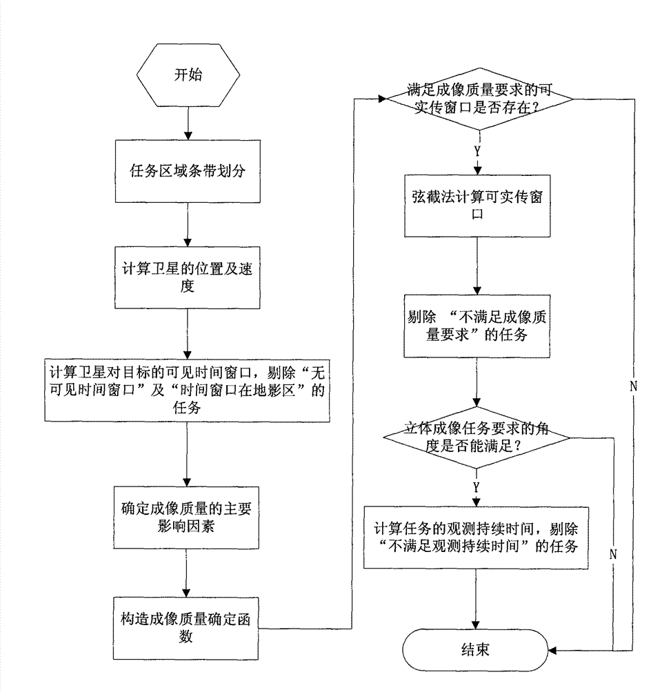
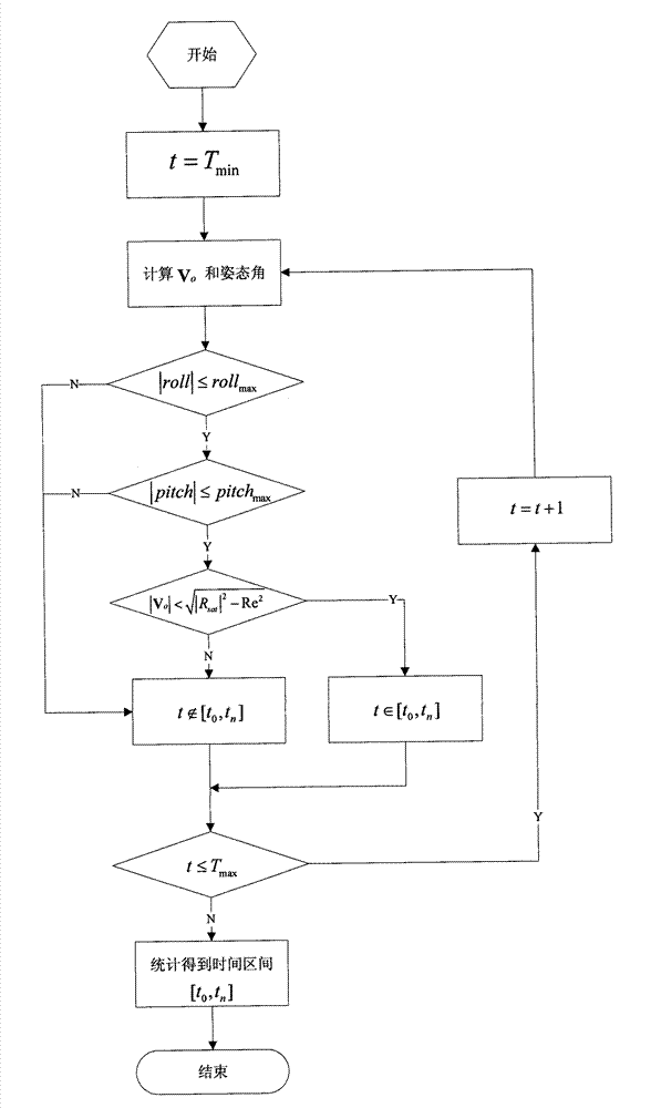
[0173] Consider a fast attitude maneuvering imaging satellite operating in a sun-synchronous circular orbit. At 00:00:00.000 UTC on July 26, 2009, the instantaneous root number is 7051.2km, the orbital inclination is 97.3087°, and the right ascension of the ascending node is 249.784°, latitude argument 0°. The satellite attitude maneuvering range is ±45° in pitch direction and roll direction. The geographic latitude and longitude information of the target is shown in Table 1, and the longitude and latitude of the four vertices of each target correspond one by one in order.

[0174] Table 1 Target geographic longitude and latitude

[0175]

[0176] This example contains a total of 6 observation tasks, tasks 1, 2, 5, and 6 are routine tasks, and the minimum allowed imaging quality is 55, 55, 65, and 55, respectively. Task 3 and task 4 are stereo imaging tasks, task 3 requires 2 stereo imaging, the pitch angles are -30° and 30° respectively, and the minimum allowed imaging q...


PUM


Abstract

The invention relates to a task preprocessing method based on imaging quality estimation, which comprises the steps of: firstly calculating a visible time window of a satellite to a ground object according to satellite orbit data, attitude mobility and ground object location information, and removing an invisible time window and tasks in earth shadow areas in the visible time window from a task list; then analyzing and determining influencing factors which influence image quality, constructing an imaging quality determination function and continuously removing tasks which do not satisfy imaging quality requirements from the task list; and for each task remained in the task list, cutting the visible time window corresponding to the tasks to obtain a task execution time window, and at the same time, calculating task observation duration according to the attitude angle of the satellite which points to the vertex of the object at each time point during task execution. When the task observation duration is within the task execution time window, the tasks are executable tasks and all executable tasks are submitted to a satellite task planning system for task planning and scheduling.

Description

technical field [0001] The invention belongs to the field of satellite task planning and scheduling, and relates to a task preprocessing method in the process of satellite task planning. Background technique [0002] Rapid attitude maneuvering imaging satellites can realize a variety of complex imaging modes with the help of rapid attitude maneuvering capabilities. Compared with traditional earth observation satellites that use sub-satellite point imaging, the rapid attitude maneuver capability greatly increases the satellite's observation opportunities for targets, and thus has stronger observation capabilities. Each imaging mode of the rapid attitude maneuvering imaging satellite is accompanied by multiple operations such as attitude maneuvering, camera switching on and off, and these operations form a coherent control command sequence. Due to the large number of instructions, the reliability of instruction arrangement and annotation and the real-time execution of instruc...

Claims


Application Information

Patent Timeline
Patent Type & Authority Patents(China)
IPC IPC(8): G01C11/00
Inventor 王抒雁谢松吕大旻刘胜利侯小瑾
Owner AEROSPACE DONGFANGHONG SATELLITE
Why Eureka
Try Eureka