Method for quickly constructing raster database facing to Virtual Earth

A raster data, fast technology, applied in the field of rapid raster data database construction for the virtual earth, can solve the problem that multi-resolution pyramids cannot efficiently process remote sensing images, so as to save mutual waiting time and eliminate the need to read data Bottleneck, efficiency-enhancing effects

Inactive Publication Date: 2015-02-18
WUHAN UNIV
View PDF3 Cites 2 Cited by
  • Summary
  • Abstract
  • Description
  • Claims
  • Application Information

AI Technical Summary

Problems solved by technology

[0018] In view of the fact that the current method of constructing multi-resolution pyramids for raster data in the virtual earth system cannot efficiently process remote sensing images with a large amount of data, in order to improve the efficiency of building multi-resolution pyramids, the technical solution provided by the invention is a virtual earth-oriented The method of building pyramids for massive raster data is mainly for files in formats that can store large amounts of data, such as tif and img

Method used


Image

  • Method for quickly constructing raster database facing to Virtual Earth
  • Method for quickly constructing raster database facing to Virtual Earth
  • Method for quickly constructing raster database facing to Virtual Earth

Examples


specific Embodiment approach

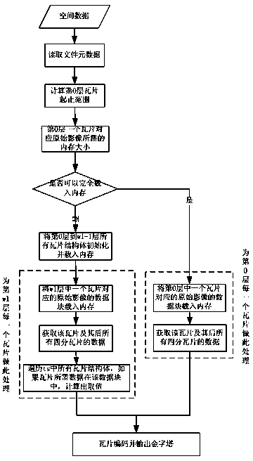
[0059] For the sake of understanding the technical solution of the present invention, at first illustrate the global multi-resolution pyramid: the global multi-resolution pyramid is a kind of infinitely subdivided based on the spherical surface, but does not change the shape of the earth body to fit the qualified network, when subdivided to a certain To a certain extent, the purpose of simulating the earth's surface can be achieved. What is adopted in the present invention is a global multi-resolution pyramid model divided by grids of equal latitude and longitude. In the raster data pyramid, each layer is cut into data blocks of uniform shape and size according to the global equilateral longitude and latitude grid division. Such a data block is called a tile.

[0060] This global multi-resolution pyramid is very suitable for organizing and managing multi-resolution massive satellite image data, because it follows the following rules:

[0061] 1) The longitude range of global ...

Embodiment

[0080] The example defines a tile structure:

[0081] typedef struct tagMemTile{

[0082] int count; / / Define count as an integer variable

[0083] int status; / / Define status as an integer variable

[0084] int level; / / define level as an integer variable

[0085] int row; / / define row as an integer variable

[0086] int col; / / define col as an integer variable

[0087] double pixelSpan; / / Define pixelSpan as a floating point number

[0088] FIBITMAP* pTileBmp; / / Define pTileBmp as a pointer to FIBITMAP

[0089]}MemTile;

[0090] Among them, tagMemTile is the name of the structure, MemTile is the variable name of the structure tagMemTile, count is the number of valid values ​​in the tile, level is the layer number of the tile, row is the row number of the tile, col is the column of the tile number, pixelSpan is the resolution of one pixel in the tile, FIBITMAP is the structure used to store tile data in FreeImage, pTileBmp is a...


PUM


Abstract

The invention relates to a method for quickly constructing a raster database facing to Virtual Earth. The method comprises the step of: beginning to construct a pyramid from an intermediate layer (a minimum memory requirement layer) if original remote sensing image data corresponding to a tile of a zero layer cannot be completely loaded to a memory once. Therefore, limit of the conventional construction layer by layer is broken through, people are only necessary to scan an original data file once, therefore, the number of I / O (Input / Output) operations is reduced, and the bottleneck problem of reading data when mass data is processed is eliminated. According to the method disclosed by the invention, a tile processing thread and a tile calculating thread are also designed. As the two threads are enabled to operate simultaneously, system resources are fully utilized; a plurality of tile calculating threads are arranged according to different hardware conditions so that the speeds of reading data and writing data by a program are matched, the synchronism of read-write operations is realized, the waiting time of the read-write operations is saved, the efficiency of pyramid construction is improved, and the method is particularly suitable for processing of extra large remote sensing data files.

Description

technical field [0001] The invention relates to the technical field of spatial data organization, in particular to a virtual earth-oriented raster data rapid database building method. Background technique [0002] Today more and more spatial data is stored in raster form (including terrain data and imagery data). Raster data has become an important data source. With the rapid development of earth observation technology, human beings can quickly acquire multi-temporal, multi-band, and multi-resolution massive remote sensing image data. With the continuous improvement of resolution, the amount of global data is also increasing at an alarming rate. For example, the remote sensing image in Fujian Province with a resolution of 30m×30m in 24-bit bmp format has 700MB. If the resolution is 1m×1m , the amount of data will reach 630GB. How to store, organize and manage raster data, how to efficiently retrieve and display the data that users are interested in, so that raster data ca...

Claims


Application Information

Patent Timeline
Patent Type & Authority Patents(China)
IPC IPC(8): G06F19/00
Inventor 向隆刚曾珍
Owner WUHAN UNIV
Why Eureka
Try Eureka