Vehicle-mounted farm three-dimensional topographical surveying device

A technology of three-dimensional topography and measuring devices, applied in measuring devices, radio wave measuring systems, satellite radio beacon positioning systems, etc., can solve the problems of heavy workload and low efficiency, and improve work efficiency, high efficiency, and ensure accuracy sexual effect

Inactive Publication Date: 2012-07-25
SOUTH CHINA AGRI UNIV
View PDF5 Cites 14 Cited by
  • Summary
  • Abstract
  • Description
  • Claims
  • Application Information

AI Technical Summary

Problems solved by technology

Patent No. ZL200820079033.X is a three-dimensional terrain measuring device based on GPS and laser technology. GPS is used to measure the latitude and longitude of a certain point in the farmland, and laser technology is used to measure the height of the point. However, this measurement method h

Method used


Image

  • Vehicle-mounted farm three-dimensional topographical surveying device
  • Vehicle-mounted farm three-dimensional topographical surveying device
  • Vehicle-mounted farm three-dimensional topographical surveying device

Examples


Embodiment 1

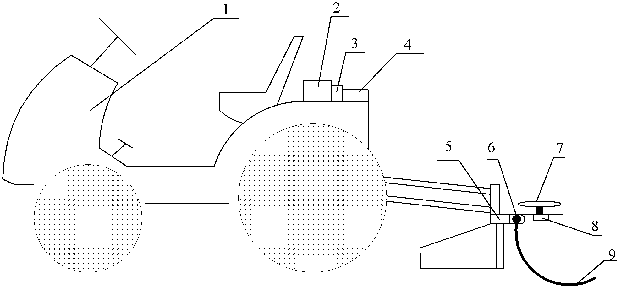
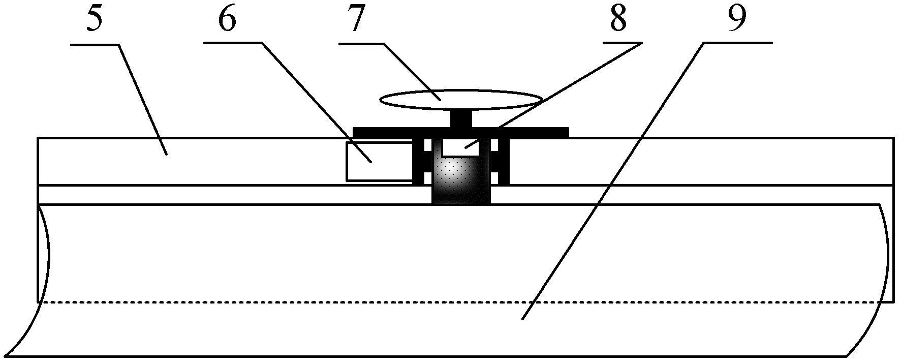
[0030] Such as figure 1 As shown, a vehicle-mounted farmland three-dimensional terrain measurement device includes a GPS receiver 4 installed on a grader 1, a GPS antenna 7, an AHRS attitude sensor 8, an absolute encoder 6, a data collector 3 and a flat blade 5.

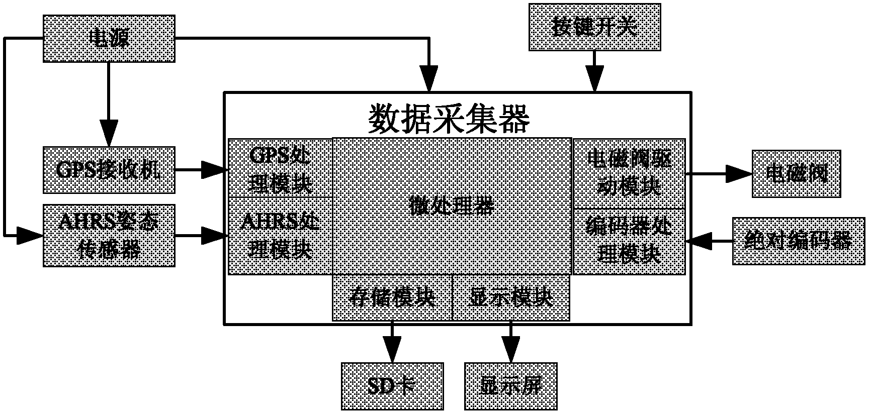
[0031] The data collector 3 is installed in the driving control room of the motor grader 1 . Such as figure 2 As shown, the data collector 3 includes a microprocessor, a GPS processing module, an AHRS processing module, an encoder processing module, a solenoid valve driving module, a display module and a storage module. The peripherals of the data collector 3 include a GPS receiver 4, an AHRS attitude sensor 8, a solenoid valve 2, an absolute encoder 6, an SD card, a display screen, a key switch and a power supply. The data collector 3 is used to receive and process the signals output by the GPS receiver 4 , the AHRS attitude sensor 8 and the absolute encoder 6 , and then control the lifting of the shovel 5 . The...


PUM


Abstract

The invention discloses a vehicle-mounted farm three-dimensional topographical surveying device which comprises a GPS (global position system) receiver, a GPS aerial, an AHRS (attitude and heading reference system) attitude sensor, an absolute encoder, a data collector and a flat shovel of a land scraper. The vehicle-mounted farm three-dimensional topographical surveying device disclosed by the invention has the advantages of high measuring accuracy, high operating efficiency and simpleness in operation, and can be used for precise measurement of three-dimensional topography of dry lands and paddy fields.

Description

technical field [0001] The invention relates to the field of three-dimensional topographical measurement of farmland, in particular to a vehicle-mounted three-dimensional topographical measurement device for farmland. Background technique [0002] In agriculture, in order to effectively improve the condition of the field, improve the irrigation efficiency and uniformity of the field, it is necessary to finely level the land. At present, conventional land leveling technology, laser control leveling technology and GPS leveling technology are widely used at home and abroad. The leveling datums of these leveling techniques are mostly determined subjectively by the operator. At present, there are few researches on the three-dimensional topographic measurement technology of farmland in China. Patent No. ZL200820079033.X's 3D topographic measuring device based on GPS and laser technology uses GPS to measure the latitude and longitude of a certain point in the farmland, and uses l...

Claims


Application Information

Patent Timeline
IPC IPC(8): G01B21/20G01S19/42
Inventor 罗锡文资双飞苗峻齐廖娟周志艳何杰严乙桉
Owner SOUTH CHINA AGRI UNIV
Why Eureka
Try Eureka