Topology discovery method of space geological data based on unstructured mode

A geological data, unstructured technology, applied in the direction of image data processing, electrical digital data processing, special data processing applications, etc., can solve problems affecting the usability of models, achieve consistency and authenticity, and reduce the amount of data stored in space , the effect of enhancing the ability of spatial expression and the efficiency of spatio-temporal analysis

Inactive Publication Date: 2012-07-25
BEIJING INSTITUTE OF PETROCHEMICAL TECHNOLOGY +1
View PDF3 Cites 13 Cited by
  • Summary
  • Abstract
  • Description
  • Claims
  • Application Information

AI Technical Summary

Problems solved by technology

Although these systems can be used to build 3D geological models, they are essentially topology-free models, i.e. each geological unit has its own wireframe grid, repeating adjacent units without sharing their boundaries, which will ultimately affect the model's Usability, it is difficult to modify and edit newly added data or constraints

Method used


Image

  • Topology discovery method of space geological data based on unstructured mode
  • Topology discovery method of space geological data based on unstructured mode
  • Topology discovery method of space geological data based on unstructured mode

Examples


Embodiment 1

[0071] Take the topology discovery method of the unstructured pattern of spatial geological data of a gold mine in Henan as an example:

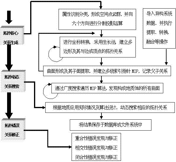
[0072] Step 101: The effective geological data in the area mainly include drilling data, geological maps, topographic maps, geological profile maps and related information. Digitize the original data through digitizers and scanners, use Oracle database tools to manage, maintain, and process information, and use 2D GIS software to generate a series of layer files.

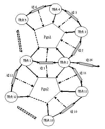
[0073] Step 102: Import the spatial geological data into the memory, and extract the point cloud to visualize in the window ( Figure 4 ). Perform attribute identification and classification to obtain 8 groups of vertices with the same attributes, and perform clustering and segmentation projection operations in the six directions of ±XY, ±XZ, and ±YZ, among which, Figure 5 is the clustering projection result P of the bedrock vertices in the second group of faults F1 in the +XY ...

Embodiment 2

[0087] Take the topology discovery method of the unstructured pattern of spatial geological data in the Beijing plain area as an example:

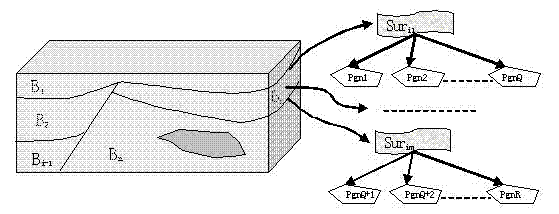
[0088] Step 201: Read in spatial geological data such as aquifer data and water level data from the heterogeneous system; perform extraction, conversion, and fusion operations on the data through the interface conversion tool to obtain grid data, wherein the number of vertices forming the polygon Pgn is 3;

[0089] Step 202: Aiming at the water level data of a certain period, obtain a series of surfaces S composed of polygons ij , and establish the corresponding multilevel surface index pointer MIP;

[0090] Step 203: Traversing the MIP algorithm through breadth search to find all surfaces Sur that constitute each aquifer ij , and establish the corresponding RTree tree to save the topological relationship between polygon-surface-entity (Table 5).

[0091] Table 5 Topological relationship between polygon-surface-solid

[0092]

[009...


PUM


Abstract

The invention relates to a topology discovery method of space geological data based on an unstructured mode, mainly comprising three-level discovery containing topology core relationship generation, topology dynamic relationship search and topology error relationship correction. The topology discovery method based on the unstructured mode aims at different manners of obtaining the space geological data, space data distribution features and required functions and application of a model, and is designed by analysis of such complex geophysical phenomenon as fault, wrinkle, lenticle, intrusive rock and on the like, so that correlations of the space, the time and a structure among large and complex space geophysical data accumulated for a long period during the mining area geological exploration are determined, and the uniformity and the authenticity of the space, the time and the structure can be maintained; and therefore, the space expression ability and the time-space analysis efficiency of three-dimensional geophysical data can be strengthened, and the advanced science means for analyzing, forecasting and evaluating geological resources can be provided for geologists.

Description

technical field [0001] The invention relates to geological exploration, spatial information processing and computer technology, in particular to a topology discovery method for unstructured patterns of spatial geological data. Background technique [0002] The research on 3D modeling theory and technology has a history of nearly 30 years. With the development of science and technology in various fields and the gradual expansion of application scope, modeling theory and technology are also constantly improving and developing. The 3D model is based on the principle of space segmentation, that is, any complex geometric shape of an object can be fitted by a finite number of simple shapes, such as strata can be approximated by many triangular faces, and a series of tetrahedral nets Lattice approximates a fault block and so on. Therefore, the core technology of 3D modeling is the 3D representation of spatial objects, and how to describe the geometric shape of spatial entities and...

Claims


Application Information

Patent Timeline
Patent Type & Authority Applications(China)
IPC IPC(8): G06T17/00G06F19/00
Inventor 武强徐华
Owner BEIJING INSTITUTE OF PETROCHEMICAL TECHNOLOGY
Why Eureka
Try Eureka