Method suitable for fast spatially-indexing global digital elevation model and remote sensing image data

A digital elevation model and remote sensing image technology, applied in the field of spatial information, can solve the problems of lack of flexibility and scalability, inefficient retrieval of massive spatial data, and low retrieval accuracy

Inactive Publication Date: 2012-09-12
BEIJING NORMAL UNIVERSITY
View PDF1 Cites 9 Cited by
  • Summary
  • Abstract
  • Description
  • Claims
  • Application Information

AI Technical Summary

Problems solved by technology

The traditional spatial index technology tightly couples the organization and storage of spatial data, expresses the hierarchical relationship of data through the data directory hierarchy, lacks flexibility and scalability, and is inefficient in retrieving massive spatial data. The influence of the curvature of the earth on the location of spatial data is not considered, and the retrieval accuracy is low

Method used


Image

  • Method suitable for fast spatially-indexing global digital elevation model and remote sensing image data
  • Method suitable for fast spatially-indexing global digital elevation model and remote sensing image data
  • Method suitable for fast spatially-indexing global digital elevation model and remote sensing image data

Examples


Embodiment 1

[0092] The implementation was carried out on a computer with 3.00GHz Intel(R) Pentium(R) 4 CPU, 2GB RAM, ATI mobility radeon X300 graphics card.

[0093] The global terrain data with a spatial resolution of 30 arc seconds and the global image "blue marble" with a resolution of 121600x121600 from Geological Survey's EROS Data Center (EDC) in the United States were selected for implementation verification. After dividing these data by ellipsoid quadtree, there are 81463 digital elevation model data and 81463 pieces of image data.

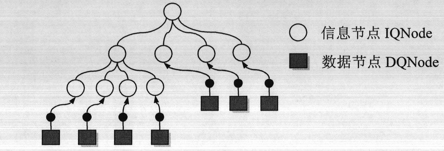
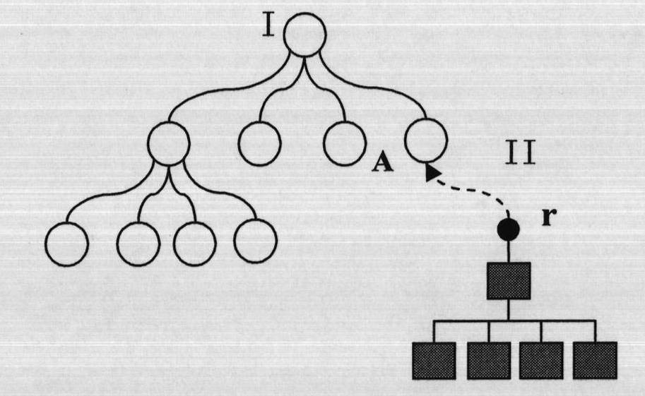
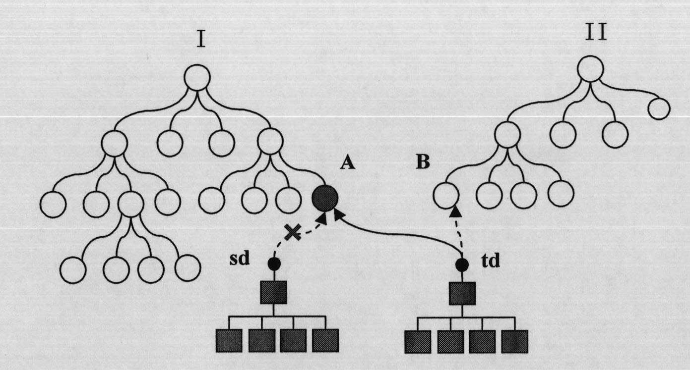
[0094] The core of the ellipsoid quadtree is that the storage location of the data is separated from the organization logic of the data. Its basic structural feature is that the periphery is scattered spatial data, and the interior is the data logical organization framework. In implementation, the map data organization based on the ellipsoid quadtree is divided into two levels: one is to perform virtual mounting operations on the distributed quadtree ...


PUM


Abstract

The invention relates to a method for indexing a global digital elevation model and remote sensing image data with an ellipsoid quad-tree technology. The method performs quad-tree grid partition to an ellipsoid surface of the earth according to a curvature of the earth, separates a data organization structure and a data storage structure through virtualization for an ellipsoid quad-tree node, and implements multistage seamless integration for mass global data by a sub-tree hooking way. According to the invention, the method overcomes defects of existing spatially-indexing technologies; the spatially-indexing method for global space data provided by the invention is high in efficiency and simple in operation; and the method has good application value in a geographic information space field.

Description

1. Technical field [0001] The invention relates to a method suitable for rapid spatial indexing of global digital elevation models and remote sensing image data, belonging to the technical field of spatial information. 2. Background technology [0002] In order to be able to access multi-resolution ultra-large-scale geographic data as quickly as possible, a reasonable database storage structure must be designed to flexibly manage data from coarse to fine. Such an adaptive database structure must be implemented using spatial indexes. [0003] With the rapid development of remote sensing technology and space data acquisition technology, people's ability to obtain global digital elevation models and images is increasing. Correspondingly, "digital cities" have been widely used in military, game and scientific research fields. The data volume of digital elevation models and remote sensing images that simulate the earth's surface is huge. For example, Google Map and Google Earth p...

Claims


Application Information

Patent Timeline
Patent Type & Authority Applications(China)
IPC IPC(8): G06F17/30
Inventor 张立强邓浩
Owner BEIJING NORMAL UNIVERSITY
Why Eureka
Try Eureka