Multi-channel time delay Doppler two-dimensional partition mapping multi-satellite and multi-time image enhanced imaging device

A two-dimensional segmentation and image enhancement technology, which is applied in the direction of measuring devices, utilizing re-radiation, radio wave reflection/re-radiation, etc., can solve the problems of insufficient application flexibility, inconvenient signal reception, and low time resolution, and achieve The effect of low cost, increased number of antennas, and high time resolution

Active Publication Date: 2014-01-22
ZHEJIANG BEITE ELECTRONICS TECH
View PDF3 Cites 0 Cited by
  • Summary
  • Abstract
  • Description
  • Claims
  • Application Information

AI Technical Summary

Problems solved by technology

However, most of the radar imaging satellites currently used are monostatic radars, which have many limitations. Its "four resistances (survivability against anti-radiation missiles, ability to detect low-altitude targets, anti-repressive noise interference ability and anti-stealth ability)" Performance is far inferior to bistatic radar
In addition, the existing imaging satellites have inconvenient signal reception, low time resolution, expensive equipment, and insufficient application flexibility.

Method used


Image

  • Multi-channel time delay Doppler two-dimensional partition mapping multi-satellite and multi-time image enhanced imaging device
  • Multi-channel time delay Doppler two-dimensional partition mapping multi-satellite and multi-time image enhanced imaging device
  • Multi-channel time delay Doppler two-dimensional partition mapping multi-satellite and multi-time image enhanced imaging device

Examples


Embodiment Construction

[0026] The present invention will be further described in detail below in conjunction with the accompanying drawings.

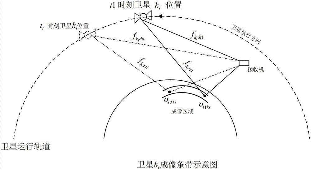
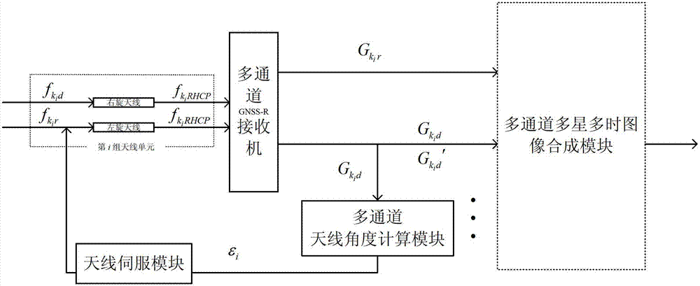
[0027] The present invention is a multi-satellite multi-time integrated enhanced imaging device for multi-channel reception and processing of direct and reflected signals of navigation satellites. The device adopts multiple groups of receiving antennas capable of intelligently adjusting angles to collect direct and reflected signals, and uses multi-channel receivers to process signals. The target is imaged by using time-delay Doppler two-dimensional segmentation mapping, and the imaging effect is enhanced by multi-satellite signal and multi-time signal synthesis, and the imaging range is expanded by spatial region image combination to obtain the final image.

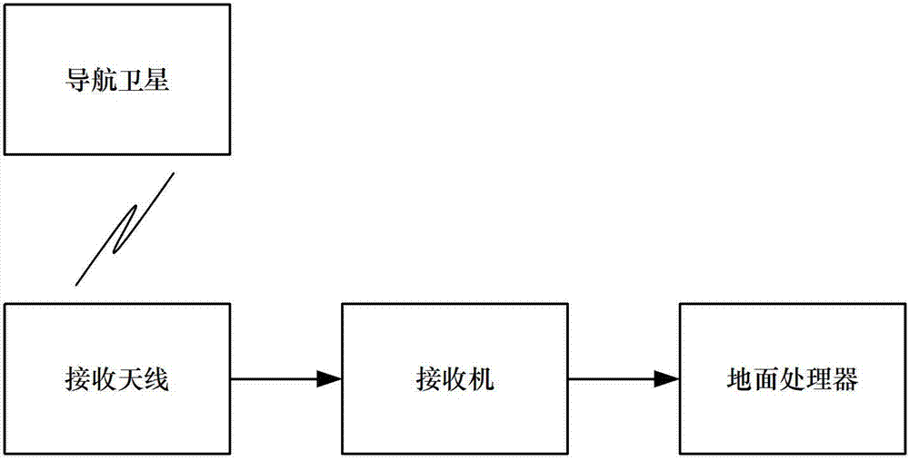
[0028] see figure 1 As shown, the traditional navigation satellite imaging device includes a ground processor, a multi-channel GNSS-R receiver, and a receiving antenna; the ground processor and the mult...


PUM


Abstract

The invention discloses a multi-channel time delay Doppler two-dimensional partition mapping multi-satellite and multi-time image enhanced imaging device, wherein a navigation satellite, an imaging device and an earth surface reflection surface form a reflection surface imaging system. A satellite direct signal is received by a right-handed antenna of a receiver, and a satellite reflected signal is received by a left-handed antenna of the receiver. When the satellite is in the range of field of vision of the receiver, specular reflection points of the satellite signal are tracked by the corresponding left-handed antenna to acquire signals, and a signal acquisition region forms a band. According to the imaging device, a plurality of satellites can be tracked at the same moment to form a plurality of bands, the bands formed by tracking each satellite signal have an overlapped region; and the device is used for processing each satellite signal acquired from the overlapped region, and the band region is imaged by utilizing reflection surface characteristic information included by the reflected signal.

Description

technical field [0001] The present invention relates to an imaging device based on the reflection signal of navigation satellites, more particularly, it refers to an imaging device with multi-channel time-delay Doppler two-dimensional segmentation mapping multi-satellite multi-time image enhancement Background technique [0002] With the development of electronic technology, modern society has higher and higher requirements for military and commercial satellite imaging. Traditional imaging satellites mainly fall into the following two categories: The first category is optical imaging reconnaissance satellites. At present, CCD cameras are mainly used to take visible light photos of ground targets. The principle is similar to that of digital cameras used in daily life. Current optical imaging reconnaissance satellites often carry infrared cameras for night reconnaissance, but they are easily restricted by meteorological conditions. CCD cameras are difficult to image in dark n...

Claims


Application Information

Patent Timeline
Patent Type & Authority Patents(China)
IPC IPC(8): G01S13/89
Inventor 杨东凯张波杨尧李明里李伟强
Owner ZHEJIANG BEITE ELECTRONICS TECH
Why Eureka
Try Eureka