Satellite navigation system principle simulation method and satellite signal simulator
A technology of satellite navigation system and simulation method, which is applied in the direction of simulator, general control system, control/regulation system, etc., can solve the problems of high technical difficulty, troublesome implementation, poor real-time performance, etc., and achieve the effect of low simulation cost
- Summary
- Abstract
- Description
- Claims
- Application Information
AI Technical Summary
Problems solved by technology
Method used
Image
Examples
Embodiment 1
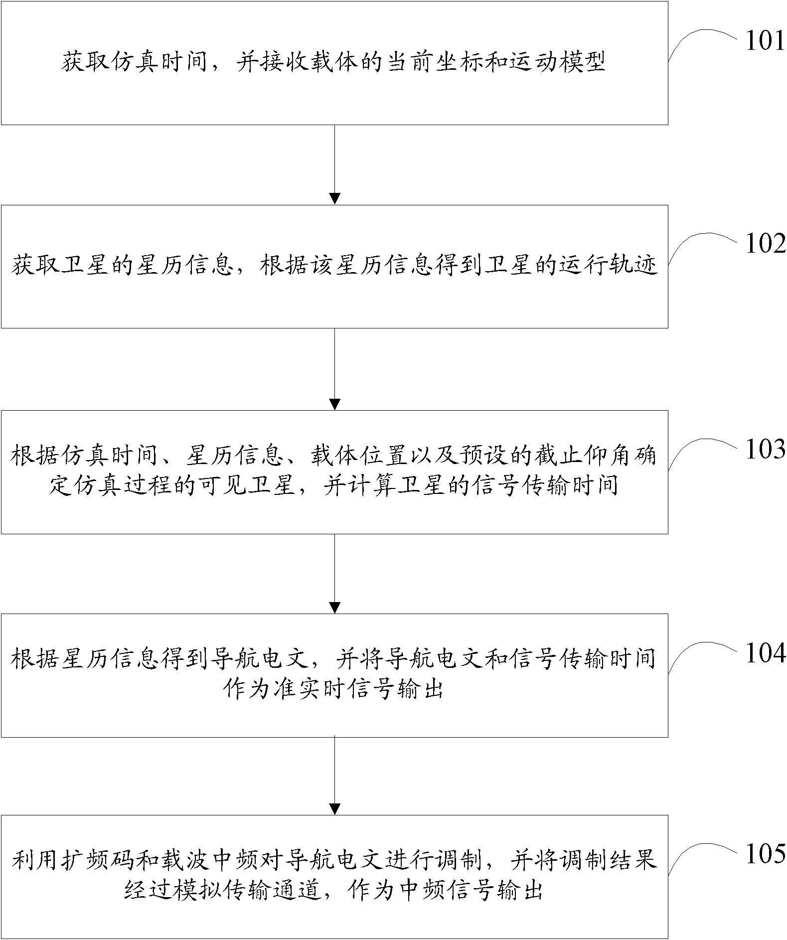
[0058] Embodiment 1 of the present invention proposes a method for simulating the principle of a satellite navigation system, the process of which is as follows figure 1 shown, including:
[0059] Step 101, obtaining the simulation time, and receiving the current coordinates and motion model of the carrier;
[0060] Step 102, obtaining the ephemeris information of the satellite, and obtaining the orbit of the satellite according to the ephemeris information;
[0061] Step 103, determine the visible satellites in the simulation process according to the simulation time, ephemeris information, carrier position and preset cut-off elevation angle, and calculate the transmission time of satellite signals;
[0062] Step 104, obtain the navigation message according to the ephemeris information, and output the navigation message and signal transmission time as a quasi-real-time signal;
[0063] Step 105, using the spreading code and carrier intermediate frequency to modulate the navi...
Embodiment 2
[0066] Embodiment 2 of the present invention proposes a satellite navigation system principle simulation method, which is improved on the basis of Embodiment 1.
[0067] It should be noted that, in this embodiment, the carrier is a simulated satellite signal receiving device in the satellite navigation simulation system, that is, an object to be positioned or an object receiving navigation services.
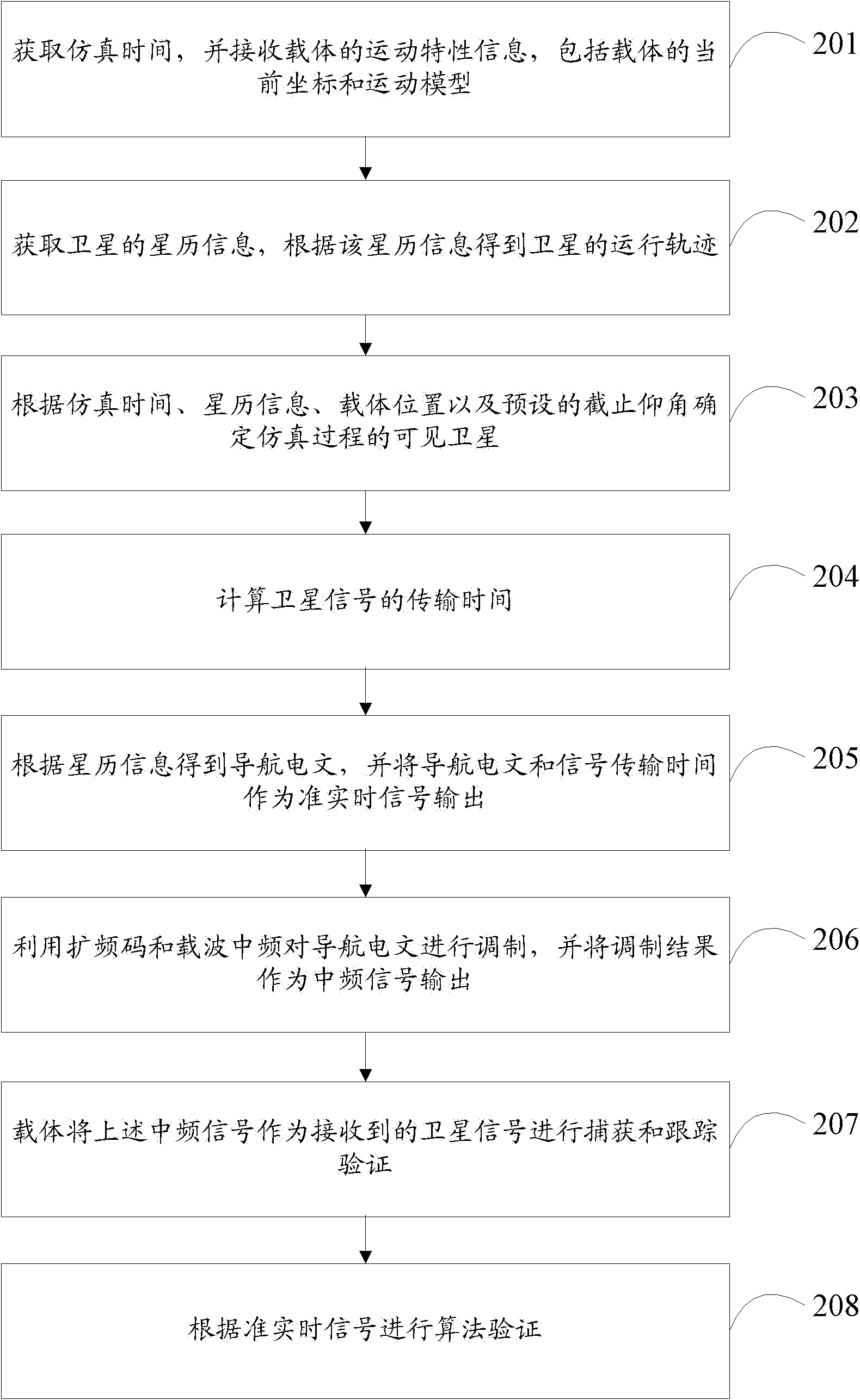
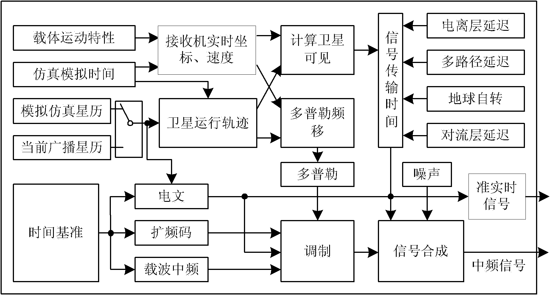
[0068] Such as figure 2 and image 3 As shown, the method specifically includes:
[0069] Step 201, obtain the simulation time, and receive the motion characteristic information of the carrier, including the current coordinates and motion model of the carrier;
[0070] Among them, the motion model of the carrier is related to time, which can be set to different modes by the user:
[0071] 1) Static; 2) Uniform linear motion; 3) Accelerated motion; 4) Complicated models obtained from the above three combinations, etc.
[0072] Correspondingly, the coordinates and velocity of ...
Embodiment 3
[0157] Such as Figure 9 As shown, Embodiment 3 of the present invention provides a satellite signal simulator, which specifically includes:
[0158] The first obtaining module 301 is used to obtain the simulation time and receive the current coordinates and motion model of the carrier;
[0159] The second obtaining module 302 obtains the ephemeris information of the satellite, and obtains the orbit of the satellite according to the ephemeris information;
[0160] The time calculation module 303 is used to determine the visible satellite of the simulation process according to the simulation time, ephemeris information, carrier position and preset cut-off elevation angle, and calculate the transmission time of the satellite signal;
[0161] The quasi-real-time signal output module 304 is used to obtain the navigation message according to the ephemeris information, and output the navigation message and signal transmission time as a quasi-real-time signal;
[0162] The intermed...
PUM
 Abstract
Description
Claims
Application Information
 - R&D
- Intellectual Property
- Life Sciences
- Materials
- Tech Scout
- Unparalleled Data Quality
- Higher Quality Content
- 60% Fewer Hallucinations
Browse by: Latest US Patents, China's latest patents, Technical Efficacy Thesaurus, Application Domain, Technology Topic, Popular Technical Reports.
© 2025 PatSnap. All rights reserved.Legal|Privacy policy|Modern Slavery Act Transparency Statement|Sitemap|About US| Contact US: help@patsnap.com


