Method for determining intersection coordinates of satellite wave beam and earth

A determination method, satellite technology, applied in the direction of reflection/re-radiation of radio waves, radio wave measurement system, use of re-radiation, etc. question

Active Publication Date: 2012-12-12
XIAN INSTITUE OF SPACE RADIO TECH
View PDF4 Cites 9 Cited by
  • Summary
  • Abstract
  • Description
  • Claims
  • Application Information

AI Technical Summary

Problems solved by technology

However, the relevant literature only gives the conversion result of the vector from the satellite orbit coordinate system to the earth coordinate system, without detailed conversion process and description, and this method does not explain the calculation process of the position vector difference, so it cannot be applied in actual calculations

Method used


Image

  • Method for determining intersection coordinates of satellite wave beam and earth
  • Method for determining intersection coordinates of satellite wave beam and earth
  • Method for determining intersection coordinates of satellite wave beam and earth

Examples


Embodiment Construction

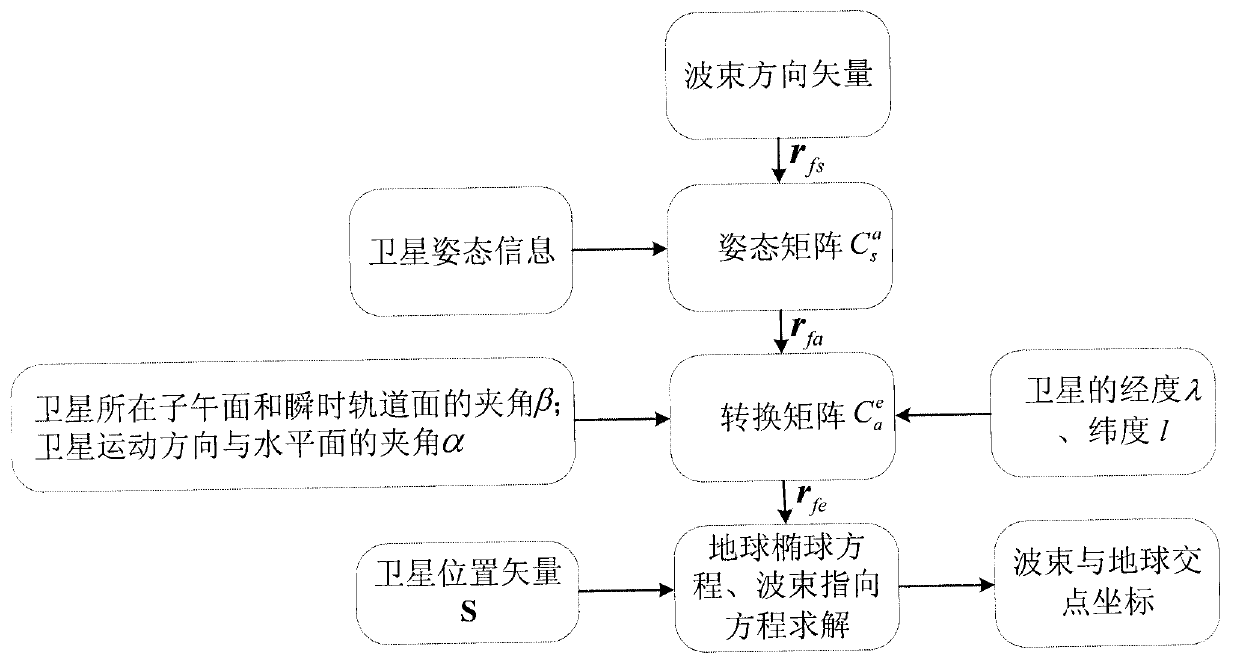
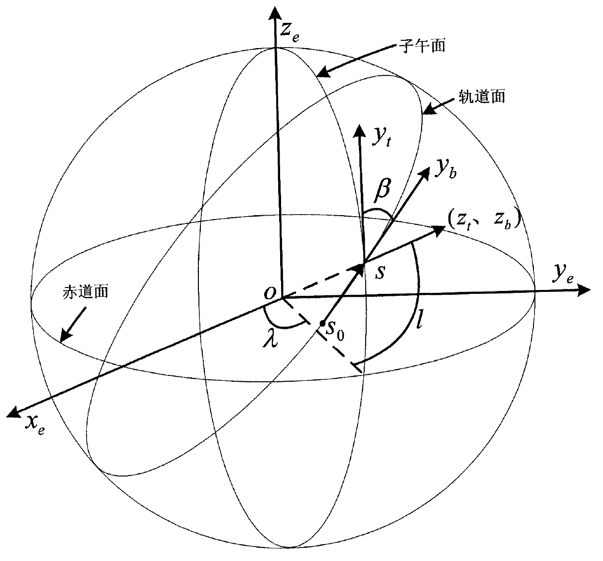
[0024] Such as figure 1 Shown, the inventive method is " bridge " with an auxiliary coordinate system, the satellite-related coordinate system (satellite body coordinate system, satellite orbit coordinate system) and navigation-related coordinate system (geographical coordinate system, earth coordinate system) are associated, establish The conversion matrix between the satellite body coordinate system and the earth coordinate system finally completes the calculation of the intersection coordinates.

[0025] The definitions of the coordinate systems involved in the steps of the present invention and the transformation matrices between them are given below.

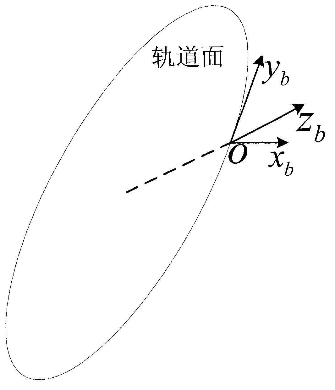
[0026] satellite body coordinate system

[0027] use ox s the y s z s Indicates that the origin o is the center of the satellite, and x s The axis points to the longitudinal axis of the satellite body, which is in the same direction as the satellite’s in-orbit motion, z s Axis points to the direction the satellite i...


PUM


Abstract

The invention discloses a method for determining intersection coordinates of a satellite wave beam and the earth. The method comprises the following steps of: (1) seeking a unit vector rfs of the satellite wave beam in a satellite body coordinate system; (2) calculating a conversion matrix of the satellite body coordinate system and a satellite track coordinate system by a yaw angle, a pitch angle and a roll angle of a satellite; (3) calculating the conversion matrix of a geographic coordinate system and an earth coordinate system by longitude lambda and latitude I of the satellite; (4) calculating the conversion matrix of an auxiliary coordinate system and the geographic coordinate system by an included angle beta of a meridian plane on which the satellite is and an instantaneous orbit plane of the satellite and an included angle alpha between a movement direction of the satellite and a geographic horizontal plane; (5) converting the unit vector rfs into the earth coordinate system to obtain rfe by coordinate system conversion; (6) associating a linear parameter equation of satellite beam incidence with an earth ellipsoid equation, and calculating two groups of coordinates [xje, yje and zje]T, wherein a group of coordinates near the satellite are coordinates of an intersection point of the satellite wave beam and the earth.

Description

technical field [0001] The invention belongs to the technical field of space microwave remote sensing, and relates to a method for determining the position relationship between a satellite beam and the earth. Background technique [0002] The spaceborne microwave scatterometer is a typical radar system that measures the backscatter coefficient σ° of the target. It is mainly used for sea surface wind field measurement. It is one of the important remote sensing instruments that can simultaneously measure sea surface wind speed and wind direction. When inverting the sea surface wind speed and wind direction from σ°, the longitude and latitude of the measurement point corresponding to σ° can be obtained by determining the coordinates of the intersection point of the satellite beam and the earth, and the sea surface wind speed and wind direction can be calculated after being brought into the inversion model. [0003] At present, foreign countries mainly use the method of vector m...

Claims


Application Information

Patent Timeline
Patent Type & Authority Applications(China)
IPC IPC(8): G01S13/88G01P5/00G01P13/02
Inventor 金阿鑫贺荣荣刘丽霞王小宁李浩谭小敏陈文新
Owner XIAN INSTITUE OF SPACE RADIO TECH
Why Eureka
Try Eureka