High-precision riverway flood inundated area generation method for mass DEM (Digital Elevation Model) data

A high-precision, data-based technology, applied in data processing applications, instruments, climate change adaptation, etc., can solve problems such as low computing efficiency, low efficiency, and memory resource consumption, and achieve the goal of improving computing speed, low efficiency, and large compression ratio Effect

Active Publication Date: 2012-12-26
CHANGJIANG RIVER SCI RES INST CHANGJIANG WATER RESOURCES COMMISSION
View PDF2 Cites 9 Cited by
  • Summary
  • Abstract
  • Description
  • Claims
  • Application Information

AI Technical Summary

Problems solved by technology

[0007] (1) Terrain data must be loaded into memory at one time, which will consume a lot of memory resources
[0008] Since the flood submersion range cannot be automatically judged in advance, the traditional submergence analysis based on the seed point filling algorithm must load all the DEM terrain data into the memory, and the terrain data stored in the form of raster consumes a lot of memory resources. With the current personal computer memory configuration conditions , it is difficult to read them all at once, which severely limits the practicability of the seed point filling and submersion analysis method;
[0009] (2) Difficult to handle massive DEM data
[0010] Due to obvious memory limitations, the submergence analysis method filled with submerged source seed points is difficult to deal with massive DEM data, so it cannot handle large-scale submergence analysis, or cannot handle high-precision terrain data, which reduces the scope of application of the submersion analysis method;
[0011] (3) Even if the DEM data is divided into blocks, it is necessar

Method used


Image

  • High-precision riverway flood inundated area generation method for mass DEM (Digital Elevation Model) data
  • High-precision riverway flood inundated area generation method for mass DEM (Digital Elevation Model) data
  • High-precision riverway flood inundated area generation method for mass DEM (Digital Elevation Model) data

Examples


Embodiment Construction

[0055] The technical solutions in the present invention will be clearly and completely described below in conjunction with the accompanying drawings in the present invention.

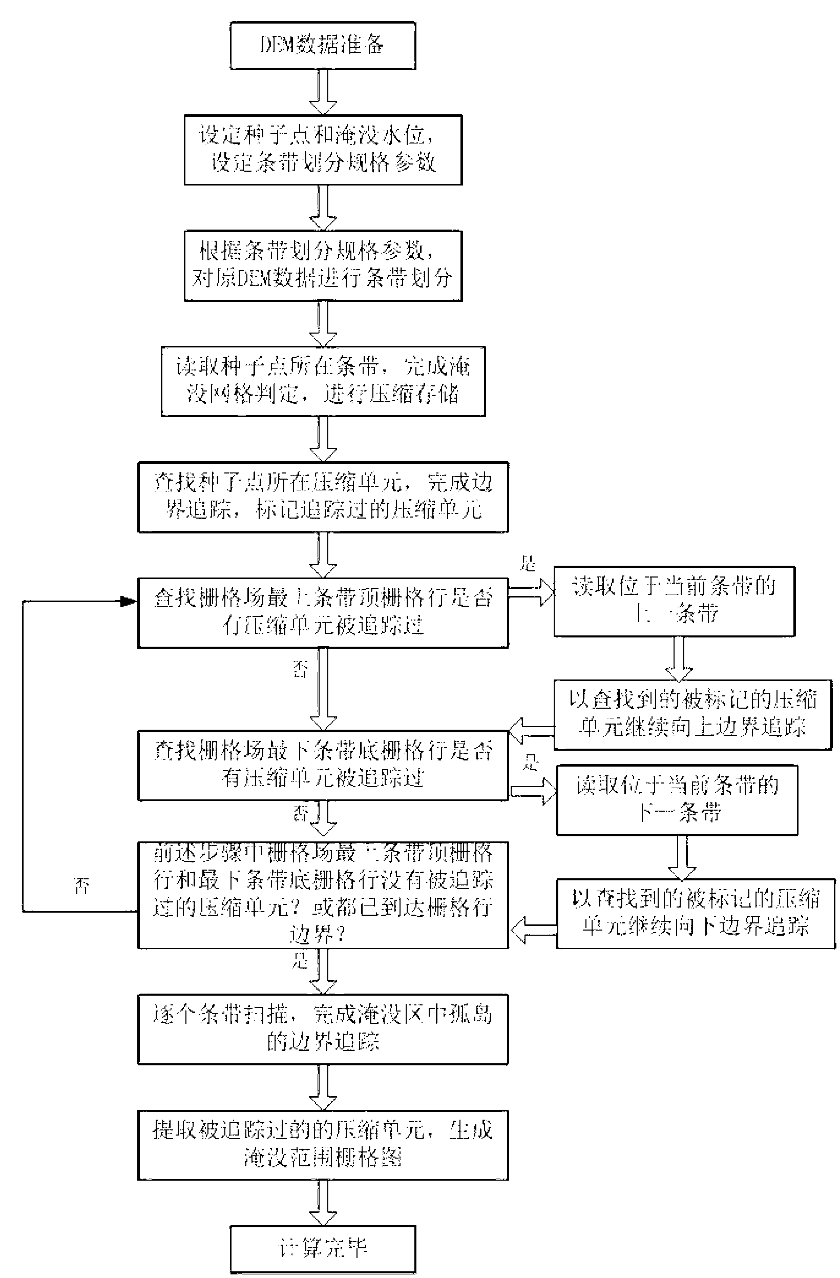
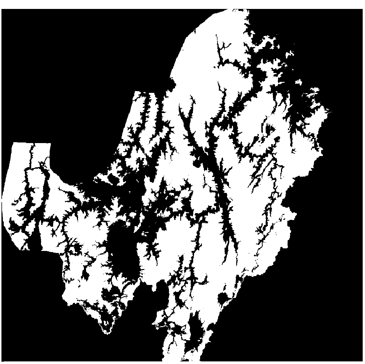
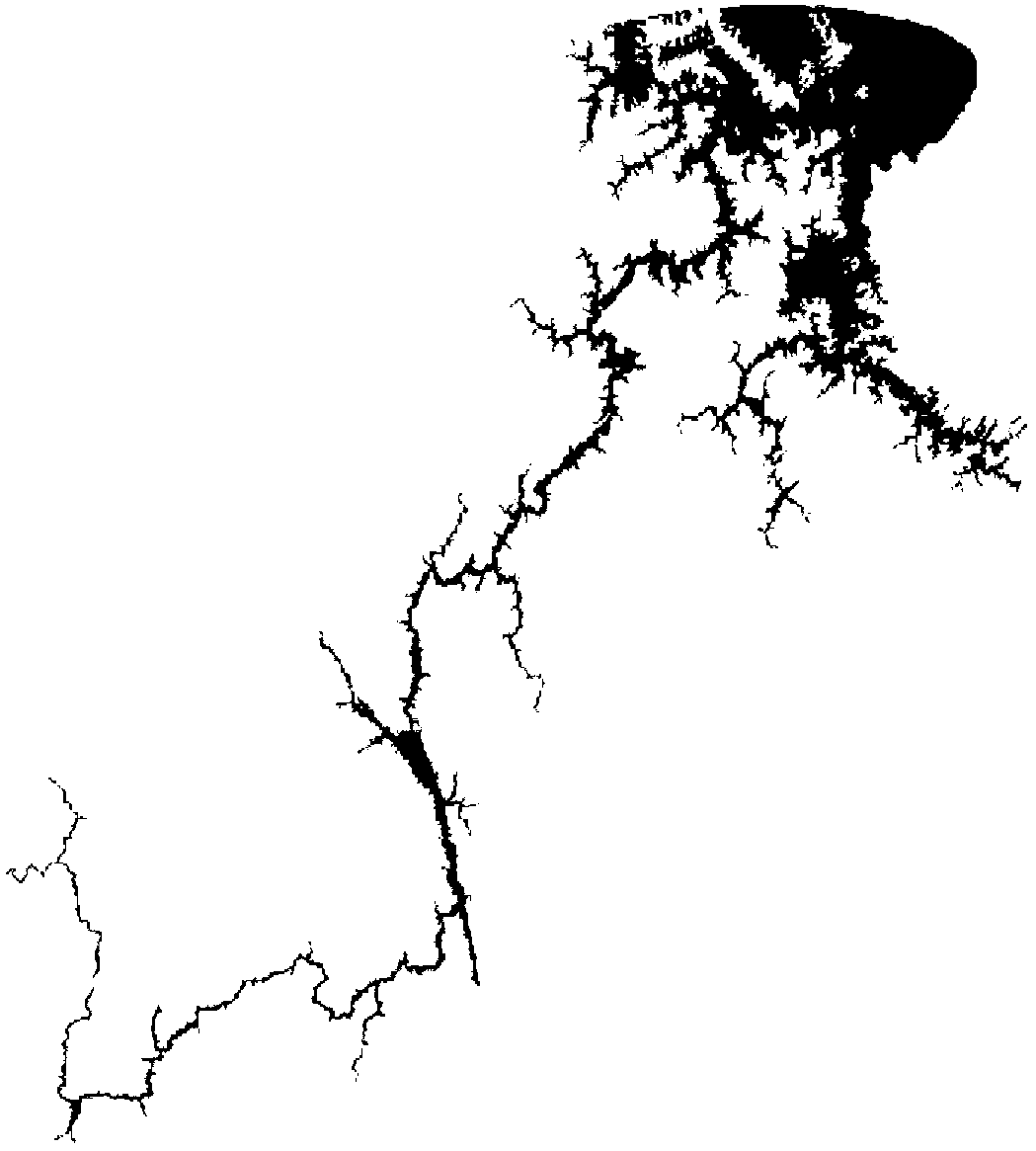
[0056] figure 1 Shown is a schematic flow chart of one embodiment of the method for generating a high-precision river flood submerged area for massive DEM data according to the present invention, figure 2 An example of DEM data in a certain area is given. The DEM data contains 19719 rows and 19454 columns, the data size is 1.43GB, and the grid width is 25 meters. image 3 is the result map of flood inundation analysis for a given seed point of an inundation source and its submerged water depth, Figure 4 It is a partially enlarged picture, and it can be clearly seen from the picture that there is a "blank" hole formed by the submerged area, which is formed by the submerged island here.

[0057] The embodiment of the present invention is oriented to a high-precision flood submerged area generation met...


PUM


Abstract

The invention relates to a high-precision riverway flood inundated area generation method for mass DEM (Digital Elevation Model) data. The method comprises the following steps of: performing stripe division on the mass DEM data; performing run length compression storage on a plurality of continuous inundation units on grid lines in stripes to reduce a data size; and finally extracting inundation ranges by virtue of a compression unit boundary tracing method, thereby generating an inundated area under complex terrain conditions. The method changes the conventional inundation source seed point filling method into grid compression storage and grid boundary tracing calculation, so that a large grid data size is processed with small memory configuration; and at the same time, a large amount of recursion judgment in the seed point filling method is avoided, and thus the computing speed is improved. The method fully utilizes digital terrain analysis and data compression storage technologies, avoids the problems generated by mass DEM data inundation analysis in the seed filling method, can be used for well performing connected domain analysis on complex terrain environments with rivers and lakes, and generates the wide-range and high-precision river and lake flood inundated area.

Description

technical field [0001] The invention relates to the technical field of water conservancy information, in particular to a method for generating high-precision river flood submerged areas for massive DEM data. Background technique [0002] my country is a country where flood disasters occur very frequently, and the losses caused by floods every year are difficult to estimate. There are many reasons for flood disasters. Large-scale rainfall in flat areas or the discharge of upstream water can cause floods. Among them, river flooding is the most common. This type of inundation analysis is usually called active inundation analysis. A central problem to be addressed in river-course inundation analysis is the identification of intricately connected areas, especially in watersheds with well-developed river networks, which are often areas of high flood frequency. [0003] With the development of spatial information technology, flood warning and disaster assessment based on digital t...

Claims


Application Information

Patent Timeline
IPC IPC(8): G06Q50/06
CPCY02A10/40
Inventor 沈定涛张煜谭德宝张治中叶松黄俊芦云峰
Owner CHANGJIANG RIVER SCI RES INST CHANGJIANG WATER RESOURCES COMMISSION
Why Eureka
Try Eureka