

Mining area land ecological damage information acquisition method based on multiple data sources
A technology for damaging information and mining land, applied in the direction of electrical digital data processing, special data processing applications, instruments, etc., can solve the problems of poor timeliness, difficulty in determining, and low precision of low-resolution images, and achieve the effect of rapid acquisition
- Summary
- Abstract
- Description
- Claims
- Application Information
AI Technical Summary
Problems solved by technology
Method used
Image

Examples
Embodiment Construction
[0025] A method for acquiring land ecological damage information in mining areas based on multiple data sources proposed by the present invention, the overall flow chart of the method of the present invention is as follows figure 1 Shown, in conjunction with accompanying drawing and embodiment describe in detail as follows:
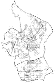
[0026] 1) Determination of the scope of the land damage area to be measured based on underground data sources: first extract the coal resource distribution and coal seam information in the mining area, and initially understand the possible range of surface land damage; and then use mining information (such as figure 2 The excavation engineering plan shown in the figure, the dotted line in the figure indicates the boundary line of each mining area, the solid line indicates, and the box indicates), and the mining subsidence is predicted in combination with the coal seam information, and the subsidence contour map is drawn; then the contour map (engineering ...
PUM
 Abstract
Description
Claims
Application Information