Combined navigation method based on earth-moon satellite united distance measurement and ultraviolet sensor

A technology of integrated navigation and sensors, applied in the field of satellite autonomous navigation, can solve the problem that the performance of autonomous navigation is easily affected by the initial error

Active Publication Date: 2013-06-12
BEIJING INST OF CONTROL ENG
View PDF5 Cites 17 Cited by
  • Summary
  • Abstract
  • Description
  • Claims
  • Application Information

AI Technical Summary

Problems solved by technology

[0005] The technical problem of the present invention is: aiming at the problem that the autonomous navigation performance based on the joint ranging of the earth and moon satellites is easily affected by the initial error, a combined navigation method based on the joint ranging of t...

Method used


Image

  • Combined navigation method based on earth-moon satellite united distance measurement and ultraviolet sensor
  • Combined navigation method based on earth-moon satellite united distance measurement and ultraviolet sensor
  • Combined navigation method based on earth-moon satellite united distance measurement and ultraviolet sensor

Examples


Embodiment Construction

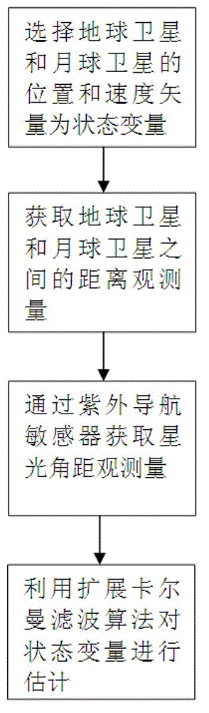
[0037] Specific embodiments of the present invention will be further described in detail below in conjunction with the accompanying drawings.

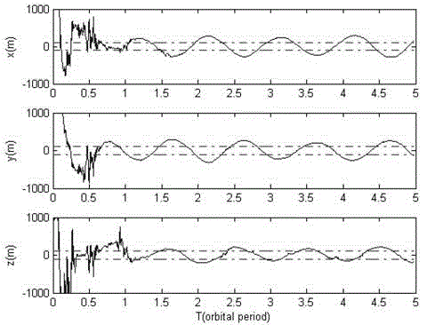
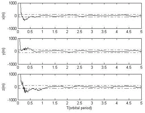
[0038] Considering that the earth-moon-satellite joint ranging information does not directly reflect the absolute position of the earth satellite and the moon satellite, the correction effect on the state variables is weak, and the state equation and observation equation of the autonomous navigation system are nonlinear, and the larger initial position The error will slow down the convergence speed of the filter, and even cause the filter to diverge. Therefore, the performance of autonomous navigation based on joint earth-moon-satellite ranging is easily affected by initial position errors. In order to overcome the influence of the initial position error, the present invention proposes to integrate the earth-moon-satellite joint ranging information and the measurement information of the ultraviolet sensor to establish an integrated nav...


PUM


Abstract

The invention discloses a combined navigation method based on earth-moon satellite united distance measurement and an ultraviolet sensor. The combined navigation method comprises the following steps of: obtaining earth-moon satellite united distance measurement information through a satellite link between an earth satellite and a lunar satellite, and obtaining satellite-light angular distance metrical information through the ultraviolet sensor; adopting an extension kalman filter algorithm, and obtaining an estimated value of navigational earth satellite and the position and speed of the satellite through processing an observed quantity order by recurrence calculation. The method provided by the invention can be used for a satellite autonomous navigation task with higher precision requirement, the dependence severity of the satellite to ground measurement and control is reduced, and the autonomous viability of a satellite system is strengthened in emergency.

Description

technical field [0001] The invention relates to a combined navigation method based on earth-moon-satellite joint ranging and an ultraviolet sensor, and belongs to the technical field of satellite autonomous navigation. Background technique [0002] Traditional satellite autonomous navigation methods include celestial navigation methods based on optical sensors (such as ultraviolet sensors) and constellation autonomous navigation methods based on inter-satellite distance measurement. It is difficult to meet the requirements of satellite high-precision autonomous navigation; based on the inter-satellite distance measurement of the earth satellite for constellation autonomous navigation and navigation, there is a "rank deficiency" problem, that is, only the distance measurement cannot form effective geometric constraints on the overall rotation of the constellation , causing the absolute positioning error of constellation satellites to gradually accumulate with time. [0003] ...

Claims


Application Information

Patent Timeline
IPC IPC(8): G01C21/00G01C21/02G01C21/20
Inventor 熊凯魏春岭何英姿
Owner BEIJING INST OF CONTROL ENG
Why Eureka
Try Eureka