SVG-based Web GIS system and relevant energy consumption monitoring system

A file system and web service technology, applied in the field of energy consumption monitoring systems, can solve the problems of lack of versatility in storage and reading, high pressure on servers and databases, and easy occurrence of blank areas in maps. The effect of less data and beautiful graphics

Inactive Publication Date: 2013-07-31
上海来信信息科技发展有限公司
View PDF4 Cites 33 Cited by
  • Summary
  • Abstract
  • Description
  • Claims
  • Application Information

AI Technical Summary

Problems solved by technology

[0008] First: The existing WebGIS data storage structure does not adopt standardized storage rules, making its storage and reading not universal, and the data is not scalable
[0009] Second: Only one data buffer storage is performed on geospatial data, and there is a phenomenon of instant data generation, so the pressure on the server and database will be very high, and blank areas are prone to appear when user services use maps;
[0010] Third: the existing geospatial data has a certain degree of closure

Method used


Image

  • SVG-based Web GIS system and relevant energy consumption monitoring system
  • SVG-based Web GIS system and relevant energy consumption monitoring system
  • SVG-based Web GIS system and relevant energy consumption monitoring system

Examples


Embodiment

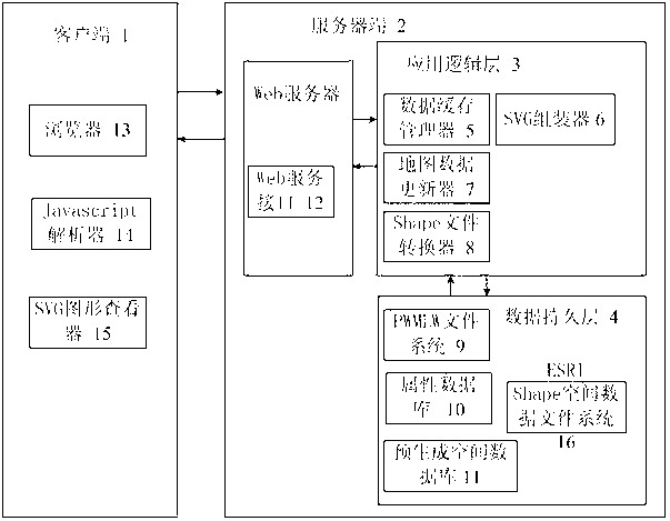
[0060] Such as figure 1 , a WebGIS system based on SVG and spatial database, including client 1 and server 2; server 2 includes data persistence layer 4, application logic layer 3 and Web service interface 12; data persistence layer 4 and application logic layer 3 Data interaction between the client 1 and the server 2 through the Web service interface 12 for data interaction.

[0061] Such as figure 1 , the data persistence layer 4 includes ESRI Shape spatial data file system 16, attribute database 10 and PEMLW file system 9, wherein: ESRI Shape spatial data file system 16 stores spatial geometric geographic data; attribute database 10 stores the graphic elements of spatial geometric geographic data Attribute data; PEMLW file system 9 stores style, layer and structure information presented by spatial geographic data. Wherein, the attribute database 10 adopts a SQL Serve database, and it may further include a SQL Serve database cache unit, so as to accelerate the response spe...


PUM


Abstract

The invention provides an SVG (Scalable Vector Graphics) based Web GIS (Web Geographic Information System) system. The system comprises a server and a client, wherein the server further comprises a data persistent layer, an application logic layer and a Web service interface, and the client comprises a browser; the data persistent layer is used for storing space geometrical geographic data, the application logic layer is used for transferring the Shape file format space geometrical geographic data stored in the data persistent layer into the SVG format, and finally forms an SVG map; and the client interacts with the server through the Web service interface, the client sends a request to the server through the Web service interface, and the server sends an SVG map to the client through the Web service interface. The system provided by the invention has the advantages that the system utilizes the advantages such as accuracy, high scalability and small data amount of the SVG, transfers the long-term accumulated geographical information in the traditional GIS system, and enables the information to be displayed in the network terminal for people to develop and use.

Description

technical field [0001] The invention relates to the technical field of internet geographic information system application, in particular to an SVG-based WebGIS system and a corresponding energy consumption monitoring system. [0002] Background technique [0003] With the development of Internet technology, Internet Geographic Information System (webGIS) has become a hot spot of Geographic Information System (GIS, Geographic Information System). One of the main development directions of WWW GIS is multivariate data access, which requires spatial data to be open in a distributed network, and any data in a distributed network can be accessed through an exchange format. At present, WebGIS at home and abroad basically uses two kinds of map generation technologies, namely raster graphics technology and vector graphics technology. [0004] Among them, the disadvantage of raster graphics technology is that it is impossible to separate text data and geometric representations, the...

Claims


Application Information

Patent Timeline
Patent Type & Authority Applications(China)
IPC IPC(8): G06F17/30
CPCY02D10/00
Inventor 毕俊人
Owner 上海来信信息科技发展有限公司
Why Eureka
Try Eureka