svg-based webgis system and corresponding energy consumption monitoring system
A file system and web service technology, applied in the field of energy consumption monitoring systems, can solve the problems of lack of versatility in storage and reading, high pressure on servers and databases, and easy occurrence of blank areas in maps. The effect of less data and beautiful graphics
- Summary
- Abstract
- Description
- Claims
- Application Information
AI Technical Summary
Problems solved by technology
Method used
Image
Examples
Embodiment
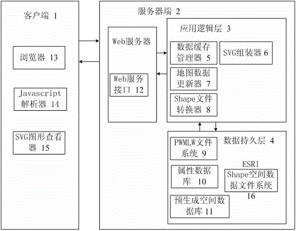
[0056] Such as figure 1 , a WebGIS system based on SVG and spatial database, including client 1 and server 2; server 2 includes data persistence layer 4, application logic layer 3 and Web service interface 12; data persistence layer 4 and application logic layer 3 Data interaction between the client 1 and the server 2 through the Web service interface 12 for data interaction.
[0057] Such as figure 1 , the data persistence layer 4 includes ESRI Shape spatial data file system 16, attribute database 10 and PWMLW file system 9, wherein: ESRI Shape spatial data file system 16 stores spatial geometric geographic data; attribute database 10 stores the primitives of spatial geometric geographic data Attribute data; the PWMLW file system 9 stores the style, layer and structure information presented by the spatial geographic data. Wherein, the attribute database 10 adopts a SQL Serve database, and it may further include a SQLServe database cache unit, so as to accelerate the respons...
PUM
 Abstract
Description
Claims
Application Information
 - R&D
- Intellectual Property
- Life Sciences
- Materials
- Tech Scout
- Unparalleled Data Quality
- Higher Quality Content
- 60% Fewer Hallucinations
Browse by: Latest US Patents, China's latest patents, Technical Efficacy Thesaurus, Application Domain, Technology Topic, Popular Technical Reports.
© 2025 PatSnap. All rights reserved.Legal|Privacy policy|Modern Slavery Act Transparency Statement|Sitemap|About US| Contact US: help@patsnap.com


