Remote-sensing image geometrical rectification method facing high mountain regions

A technology for geometric correction and high mountain areas, applied in the field of remote sensing surveying and mapping, can solve problems such as nonlinear geometric distortion of remote sensing images, achieve the effect of eliminating interference and improving accuracy

Inactive Publication Date: 2013-09-11
XINJIANG INST OF ECOLOGY & GEOGRAPHY CHINESE ACAD OF SCI
View PDF3 Cites 11 Cited by
  • Summary
  • Abstract
  • Description
  • Claims
  • Application Information

AI Technical Summary

Problems solved by technology

[0003] The purpose of the present invention is to provide a geometric correction method for remote sensing images in high mountain areas. This method aims at the problem of nonlinear terrain distortion in remote sensing images in high mountain areas. The idea of ​​eliminating the nonlinear geometric deviation of the image and then eliminating the linear system error of the image
This method focuses on solving the problem of nonlinear geometric distortion of remote sensing images under rough terrain conditions

Method used


Image

  • Remote-sensing image geometrical rectification method facing high mountain regions
  • Remote-sensing image geometrical rectification method facing high mountain regions
  • Remote-sensing image geometrical rectification method facing high mountain regions

Examples


Embodiment

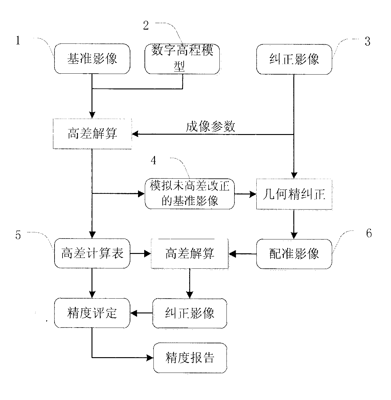
[0029] The geometric correction processing in the method of the present invention is mainly aimed at domestic resource satellite data--No. 2 CBERS02L1B level remote sensing data product of China-Pakistan Resources, the data location is near Bogda Peak in Tianshan Mountain, the orbit number is P32R51, and the imaging time is June 2005 On March 6, the data was released by the China Resources Satellite Application Center; the reference image used is the orthographic product of the Landsat Landsat released by the US Geological Survey, with a spatial resolution of 30 meters; the elevation data uses SRTM, which has been widely used at present DEM data product, the data is also released by the U.S. Bureau of Geographical Survey, in which the blank area in the mountainous area has been repaired and filled, and the plane resolution is 90m. The technical process is mainly divided into four main steps: data preprocessing, elevation deviation simulation, geometric precision correction, and...


PUM


Abstract

The invention relates to a remote-sensing image geometrical rectification method facing high mountain regions. The remote-sensing image geometrical rectification method aims at solving the problem of nonlinear terrain distortion in remote-sensing images of high mountain regions and adopts the theory of firstly calculating nonlinear geometrical deviation caused by hypsography and then eliminating image linear system errors. The remote-sensing image geometrical rectification method includes: calculating geometrical deviation of a reference image in different heights according to aim image imaging geometrical relationships before using a reference orthoimage to perform geometrical rectification on the aim image to be rectified to generate a height difference calculation sheet, simulating the state of the reference image before terrain rectification, then performing accurate matching on the aim image and the simulated reference image, enabling geometrical deviation of the aim image and the simulated image to be within a standard range, performing back calculation on geometrical deviation of the aim image caused by topographic relief pixel by pixel according to the height difference calculation sheet to generate precise geometrical rectification products of high mountain regions. The remote-sensing image geometrical rectification method mainly solves the problem of nonlinear geometrical distortion of remote-sensing images under rugged terrain conditions.

Description

technical field [0001] The invention relates to a processing method for geometric correction of satellite remote sensing images, which is used for the production of remote sensing standard geometric correction data products and belongs to the field of remote sensing surveying and mapping. Background technique [0002] Geometric correction processing of remote sensing images is a key step in preprocessing of remote sensing images, and it is the premise of remote sensing application analysis such as quantitative analysis of remote sensing, change monitoring and thematic information extraction. The purpose of remote sensing image geometric correction is to correct the geometric offset of the image relative to the ground target caused by factors such as sensor attitude, earth rotation, earth curvature, and terrain fluctuations during the imaging process of satellite images. According to the type, it can be divided into system distortion and external distortion. System distortion...

Claims


Application Information

Patent Timeline
Patent Type & Authority Applications(China)
IPC IPC(8): G06T5/00G06T7/00G06T7/33
Inventor 李均力包安明
Owner XINJIANG INST OF ECOLOGY & GEOGRAPHY CHINESE ACAD OF SCI
Why Eureka
Try Eureka