Navigation X-band radar wave height inverse calculation method based on information entropy

An X-band, information entropy technology, applied in radio wave measurement systems, instruments, etc., can solve the problems of uneven wave field, influence, inaccurate wave spectrum method, etc.

Active Publication Date: 2013-09-25
江苏海兰船舶电气系统科技有限公司
View PDF4 Cites 13 Cited by
  • Summary
  • Abstract
  • Description
  • Claims
  • Application Information

AI Technical Summary

Problems solved by technology

The disadvantage of this method is that the Fourier transform is based on the assumption of spatial uniformity and temporal stability of the wave field, which rarely exists in real sea areas, especially near-shore areas.
In the coastal sea area, with the shallower water depth and the reflection and refraction of the shore to the wa

Method used


Image

  • Navigation X-band radar wave height inverse calculation method based on information entropy
  • Navigation X-band radar wave height inverse calculation method based on information entropy
  • Navigation X-band radar wave height inverse calculation method based on information entropy

Examples


Embodiment Construction

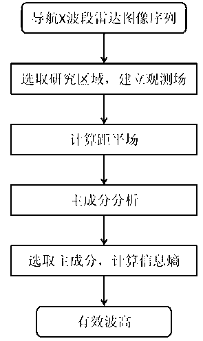
[0037] Below in conjunction with accompanying drawing, technical scheme of the present invention is described in further detail:

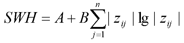
[0038] In the present invention, a kind of information entropy-based navigation X-band radar sea wave height inversion algorithm is proposed, such as figure 1 As shown, the specific steps are as follows:

[0039] 1. Select a research area from the navigation X-band radar image, generally select the area with obvious wave stripes, the size of the area can include 30° in azimuth and 256 pixels in radial direction. The observation data field matrix is ​​established by using the gray value of the radar image in the research area, where the number of rows of the matrix is ​​the number of spatial points in the research area, and the number of columns of the matrix is ​​the length of the time series corresponding to each spatial point. Calculate the mean value of the observed data field matrix, and subtract this mean value from each element of the matrix...


PUM


Abstract

The invention discloses a navigation X-band radar wave height inverse calculation method based on information entropy. The navigation X-band radar wave height inverse calculation method comprises the steps that first an anomaly field of an observation information field is calculated, principal component analysis is used for decomposing the anomaly field into different components, and then the relation between the information entropy of a principal component and an effective wave height is used for calculating the effective wave height. According to the navigation X-band radar wave height inverse calculation method based on the information entropy, the principal component analysis is used for decomposing a wave field into different components, the wave height information of waves is extracted from the principal component, the problems of the unevenness of the wave field and the influence caused by noise in radar images are effectively solved, and meanwhile the method for inversely calculating the effective wave height by the information entropy has the advantages of being simple and easy to achieve and high in precision.

Description

technical field [0001] The invention relates to an information entropy-based navigation X-band radar sea wave height inverse calculation method, which belongs to the technical field of marine remote sensing. Background technique [0002] Waves have an important impact on people's production and life, such as sea navigation, fishery production, and near-shore port and waterway construction, etc. are closely related to waves. In addition, ocean wave information is also required for the understanding of mesoscale and small-scale processes in the ocean and the prediction of storm surges. Wave height is an important parameter to reflect the characteristics of ocean waves, therefore, the observation of wave height has important practical significance. Traditional observation methods such as buoys can accurately obtain information on changes in wave height, but they can only obtain changes in fixed points of waves, and are not easy to manage and maintain. Navigational X-band rada...

Claims


Application Information

Patent Timeline
IPC IPC(8): G01S7/02
Inventor 何宜军陈忠彪丘仲锋
Owner 江苏海兰船舶电气系统科技有限公司
Why Eureka
Try Eureka