Three-dimensional virtual display method of real-space three-dimensional geographic entity

A technology of real space and three-dimensional geography, applied in the field of geographic information systems, can solve the problems of limiting the simulation effect of the audience's virtual world, failing to meet the simultaneous observation and timely interaction of multiple people, etc.

Inactive Publication Date: 2013-10-02
广西智慧城市科技有限公司
View PDF4 Cites 31 Cited by
  • Summary
  • Abstract
  • Description
  • Claims
  • Application Information

AI Technical Summary

Problems solved by technology

[0003] At present, the virtual reality display mode is always limited to computer screens or two-dimensional wall screens. The three-dimensional display mode only has psychological depth of field, without physical depth of field, which limi

Method used


Image

  • Three-dimensional virtual display method of real-space three-dimensional geographic entity
  • Three-dimensional virtual display method of real-space three-dimensional geographic entity
  • Three-dimensional virtual display method of real-space three-dimensional geographic entity

Examples


Example Embodiment

[0065] Example:

[0066] The real projection space length, width and height parameters selected in this embodiment are 3 meters*3 meters*3 meters.

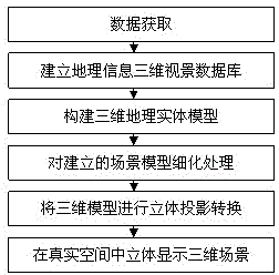
[0067] The specific steps are:
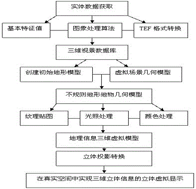
[0068] (1) Establish a geographic information 3D visual database:

[0069] The geographic entity in the terrain feature is defined as the basic unit in the real space three-dimensional display technology, referred to as Entity. An entity corresponds to a small cuboid with the center point of the terrain feature as the sampling point, and the value is the sampling value of the sampling point. Expressed as:

[0070] E={x,y,z}x,y,z∈R.

[0071] Quantitatively set the basic eigenvalues ​​of the corresponding entity, including the geometric characteristics, optical characteristics, and time characteristics of the entity. Because the real space 3D data is rich in information and the amount of data is also large, and it is combined with algorithms such as computer graphics and image processing, so This...


PUM


Abstract

The invention discloses a three-dimensional virtual display method of a real-space three-dimensional geographic entity. The three-dimensional virtual display method comprises the following steps: by starting from special requirements of real-space three-dimensional projection on a data format, preprocessing a huge amount of three-dimensional data of the three-dimensionally displayed geographic entity to remove redundant data and obtain effective three-dimensional entity data; performing three-dimensional modeling on an irregular terrain according to the geographic entity data to obtain views from multiple angles in three-dimensional display, and processing and optimizing the views in combination with a real-space three-dimensional display technology; and according to a real-space three-dimensional display imaging principle, analyzing a dynamic three-dimensional entity imaging principle, establishing a three-dimensional projection system in a real space, and projecting the established three-dimensional terrain model in the real space according to a certain proportion, thus achieving three-dimensional simulative display of three-dimensional geographic information. By the three-dimensional virtual display method, the three-dimensional geographic information is displayed more vividly, so that a person can feel a three-dimensional real effect of the three-dimensional geographic information in the real space more intuitively.

Description

technical field [0001] The invention belongs to the technical field of geographic information system (GIS), and in particular relates to a three-dimensional virtual display method of three-dimensional geographical entities in real space. The method uses three-dimensional projection simulation to simulate geographical entities in the real world according to a certain ratio. Realize prototype virtual visualization projection display in real space. Background technique [0002] Virtual reality (virtual reality) refers to the use of computers to generate realistic three-dimensional visual, auditory, tactile and other sensory forms of virtual world, in which the scene can be watched and roamed freely in the computer virtual environment. In the application of geographic information system, through the modeling and texture mapping of three-dimensional ground objects, the display of three-dimensional realistic graphics and images on the computer screen or two-dimensional wall plane ...

Claims


Application Information

Patent Timeline
IPC IPC(8): G06T17/00G02B27/22
Inventor 李景文陆妍玲
Owner 广西智慧城市科技有限公司
Why Eureka
Try Eureka