Method for improving accuracy of satellite altimetry cross point

A satellite altimetry and intersection technology, applied in the field of satellite altimetry, can solve the problems of fitting errors affecting the accuracy of intersection positions and large computational workload.

Inactive Publication Date: 2013-10-23
HOHAI UNIV
View PDF4 Cites 13 Cited by
  • Summary
  • Abstract
  • Description
  • Claims
  • Application Information

AI Technical Summary

Problems solved by technology

[0003] In the traditional method, the determination of the position of the intersection is jointly calculated by the approximate position and the precise position. The curve fitting of the ascending and descending arcs is the key to solving t

Method used


Image

  • Method for improving accuracy of satellite altimetry cross point
  • Method for improving accuracy of satellite altimetry cross point
  • Method for improving accuracy of satellite altimetry cross point

Examples


Embodiment Construction

[0051]Below in conjunction with specific embodiment, further illustrate the present invention, should be understood that these embodiments are only used to illustrate the present invention and are not intended to limit the scope of the present invention, after having read the present invention, those skilled in the art will understand various equivalent forms of the present invention All modifications fall within the scope defined by the appended claims of the present application.

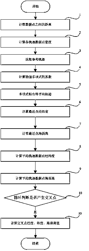
[0052] Such as figure 1 Shown, the method for improving satellite altimetry intersection precision of the present invention, comprises the following steps:

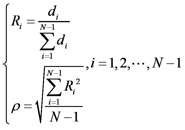
[0053] (1) Calculate the distance d between adjacent data points on each trajectory i ,Calculated as follows:

[0054] d i = ( x i - x ...


PUM


Abstract

The invention discloses a method for improving the accuracy of a satellite altimetry cross point. The method comprises the following steps of: calculating the distance and the data density between adjacent data points on each track; selecting a track with the smallest data density in all the tracks as a reference track and the other tracks as tracks to be averaged; selecting the frequency of interpolation polynomial for each track to be averaged; fitting the tracks to be averaged by the polynomials; calculating the longitude, the latitude and the sea level height of a point, closest to each reference point, on each fitted curve; calculating the longitude, the latitude and the sea level height of a data point on an averaged track; circularly judging whether a cross point is generated and calculating the longitude, the latitude and the sea level height of the cross point; and converting the judgment of the cross point between two tracks into judgment on whether a connecting line section between two adjacent height measurement data points in any track forms an intersection point with a connecting line section between two adjacent data points in the rest tracks, wherein the intersection point is taken as the cross point. Compared with conventional methods, the method has the characteristics of high accuracy, easiness in calculation, wide application range, high operation efficiency and the like.

Description

technical field [0001] The invention relates to the technical field of satellite altimetry, in particular to a method for improving the accuracy of satellite altimetry intersections. Background technique [0002] Collinear averaging is a method designed according to the repeatability of periodic satellites to reduce satellite orbit errors. By studying the sea surface height values ​​along the collinear trajectory, we can find the long-wave changes of the sea surface height, which are mainly caused by the radial orbit error and the time-varying part of the sea surface. After the collinear average, the cross point discrepancy value can be calculated, which also reflects the orbit radial error. Its determination is very important for the cross point adjustment of the satellite survey height, and its accuracy is mainly determined by the cross point position. [0003] In the traditional method, the determination of the position of the intersection is jointly calculated by the ap...

Claims


Application Information

Patent Timeline
IPC IPC(8): G01C5/00
Inventor 岳建平梁子亮吕志才顾景强郑应新董杰
Owner HOHAI UNIV
Why Eureka
Try Eureka