Traffic monitoring system and method

a traffic monitoring and traffic technology, applied in the field of traffic monitoring systems, can solve the problems of almost all major arteries, substantial congestion, and the national highway system developed in the early part of the century have not fared any better, so as to increase the density of base stations, improve data collection ability, and increase the potential frequency reuse

Inactive Publication Date: 2003-01-07
STRATEGIC DESIGN FEDERATION W LLC
View PDF20 Cites 326 Cited by
  • Summary
  • Abstract
  • Description
  • Claims
  • Application Information

AI Technical Summary

Benefits of technology

Hereby a method is provided which makes traffic monitoring of almost any road having coverage of a mobile telecommunications network feasible. The inventive method takes advantage of the large amount of users of mobile devices, such as mobile phones or other wireless devices in a telecommunications network, and the signals that are transmitted between these devices and a plurality of base stations with known locations. The locations of the base stations tend to follow transit arteries, such as highways, where conversations and usage of wireless services is likely to take place. Further, many mobile devices are located in vehicles, such as cars, trucks, buses, etc, or carried by persons located in such vehicles. Analyzing these signals in conjunction with the information where base stations are located in relation to roads and highways, it becomes possible to monitor the traffic on virtually any road covered by a mobile telecommunications network. The invention will benefit from the higher potential frequency reuse in third generation mobile telecommunication systems coupled with capacity requirements for new wireless applications, which will result in further increase in the density of base stations in urban areas and highly trafficked thoroughfares further enhancing the data-gathering ability of the proposed method.
Basically, there are two techniques for positioning a mobile device using a mobile telecommunications network, terminal based or network based. Network based solutions do not require a special kind of handset which would imply that all radio signals to and the wireless network could be used to compute traffic patterns. The present invention particularly benefits from the network based positioning, which eliminates specialized software in the mobile devices. Examples of network based solutions include the Cell Global Identity and Timing Advance (CGI+TA) and the Uplink Time of Arrival (UL-TOA) methods. Furthermore, Doppler Shift from the radio signal of a mobile device can be used to estimate location and speed of vehicles. With the advent of GPRS technology in second generation wireless networks and the resulting "always on" conditions for the wireless users, the data flow to the network will be substantially increased. Third generation (3G) systems will further enhance these characteristics.
To enhance measurement accuracy, prior measurement readings could be used in the specific areas of interest to filter relevant data and further enhance the accuracy of location-specific readings.

Problems solved by technology

National highway systems developed in the early part of the century have not fared any better.
The unprecedented growth in vehicle ownership, coupled with public transportation and the high rate of commerce using trucking services has caused substantial congestion as well in almost all major arteries of communication.
Traffic and congestion are undesirable, as they are the cause of increased pollution, additional costs to society and in many instances they contribute to accidents.
Most of these systems employ sensors that are inherently limited in the coverage area and therefore such systems in most instances are deployed in limited critical areas and depend heavily on cameras and basic weather sensors.
While these methods are improving the overall safety of some areas they do not provide a comprehensive solution to the problem of traffic and vehicular congestion monitoring.
Systems that depend electronic monitoring embedded in the roadway, require a large number of sensors with the associated large investment required and in addition such solutions require constant and costly maintenance.
Such approaches provide more or less weather interference-free monitoring, but are mainly local solutions, which result in large investments and high maintenance costs and limit them to monitor specific areas.
Such agreements are likely to be expensive to implement and more likely not possible to implement in a homogeneous manner over different areas, which negate the ability to generate large area mapping information.
Such approach would prove often impractical to implement.
In addition, it would be necessary to have installation of such units in a sufficiently large number of vehicles to generate meaningful data, which would, in any case, limit the acquisition of data to areas where the units are outfitted and circulate at any point in time.

Method used


Image

  • Traffic monitoring system and method
  • Traffic monitoring system and method
  • Traffic monitoring system and method

Examples


Embodiment Construction

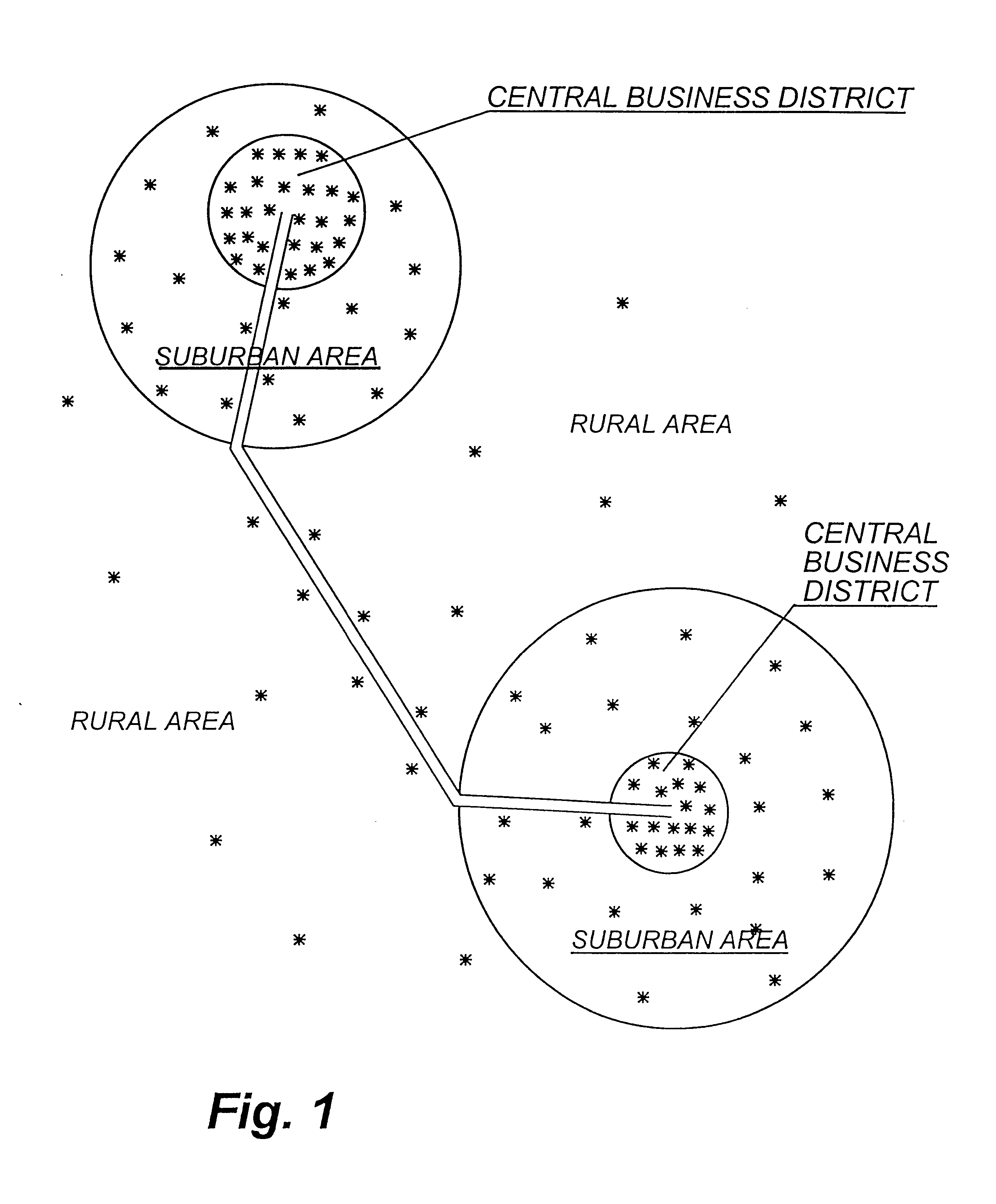
The proposed traffic monitoring system could conceivably cover all areas where a mobile telecommunications network is deployed. To the extent that vehicular traffic is more likely to be heavy in critical thoroughfares, these areas are of particular interest, and will receive more data as more vehicles will be present, and more likely to engage in conversations (or simply carry wireless phones). In general, the usage of mobile devices in an area reflects the number of base stations located that area, which is illustrated in FIG. 1.

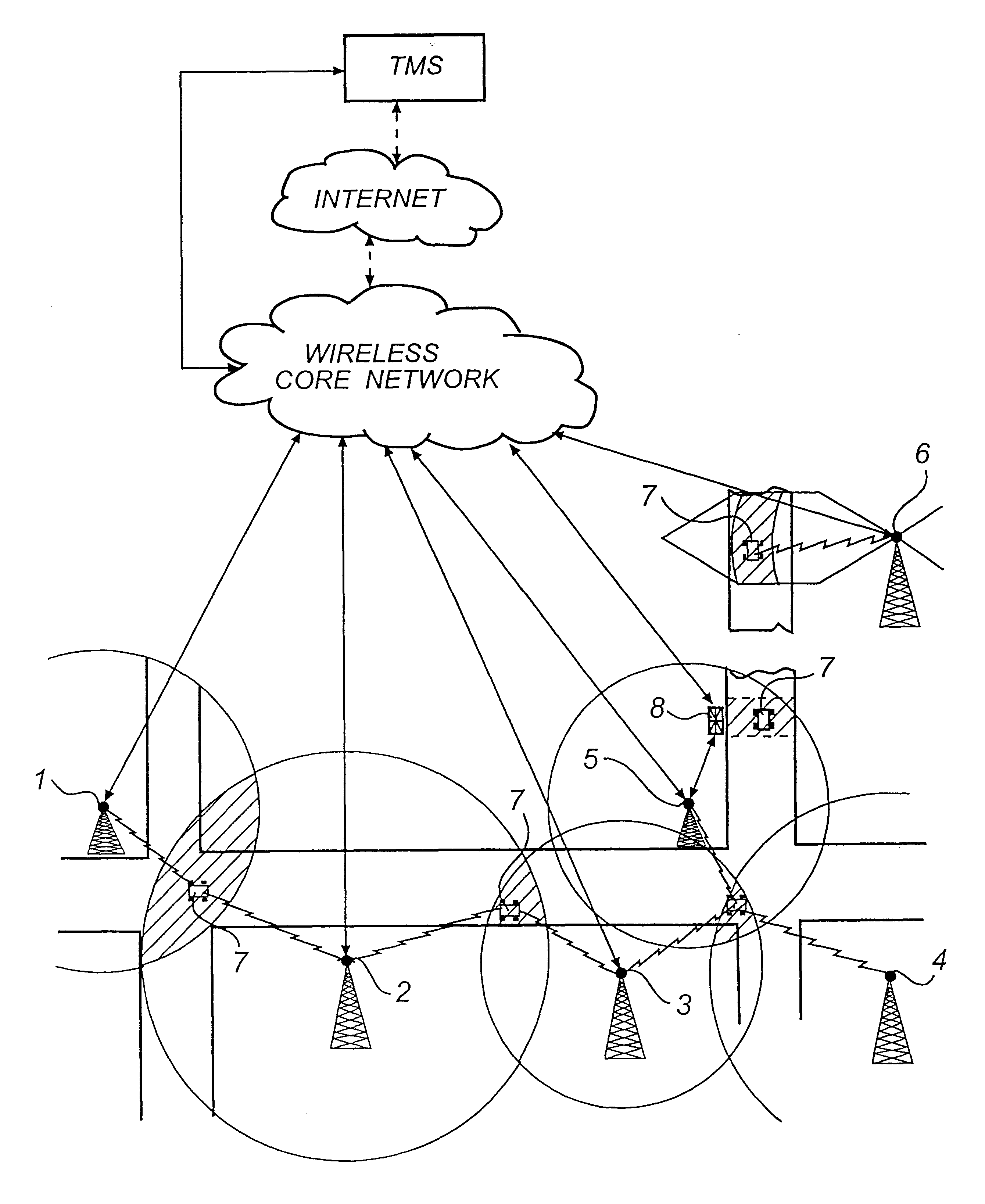
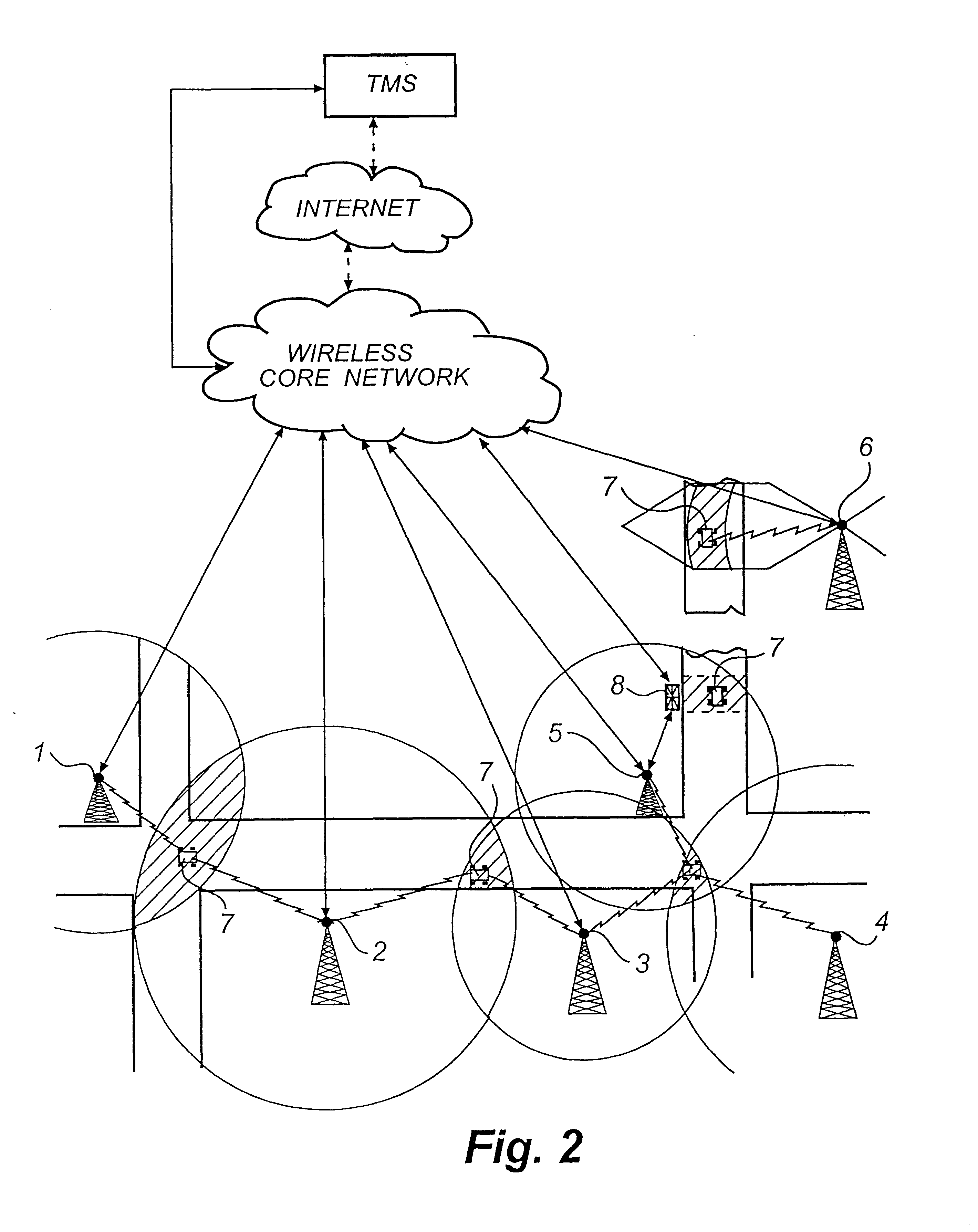
Referring to FIG. 2, it is conceivable that different techniques could be used for positioning a mobile device at different locations as these locations may even belong to different operators or be of different types such as CDMA, GSM, etc. In addition, the telecommunications networks could use different technologies and therefore require different algorithms. This is illustrated in FIG. 2, wherein base stations 1 and 2 use Doppler Shift data to compute spe...


PUM


Abstract

A method and system for traffic monitoring and prediction of traffic intensity. The method comprises the steps of determining at least twice, within a specified time interval, geographical positions of a plurality of mobile devices in a mobile telecommunications network. This is done by means of measuring at least one property of signals transmitted between the mobile devices and base stations in the mobile telecommunications network. At least a subset of the geographical positions are compared with a route of a road provided in a route database in order to identify mobile devices having routes corresponding to at least a part of the road route. A velocity for the identified mobile devices based on the at least two positions, and the calculated velocity of at least one identified mobile device is compared with a reference velocity of the road in order to predict traffic intensity on the road. A system for short range monitoring is also provided.

Description

The present invention relates in general to a method and a system for traffic monitoring and in particular to measuring traffic intensity and congestion on roads.During the latter part of the twentieth century with the expansion of metropolitan areas and the development of new suburban housing, society has experienced longer commuting times to work and higher vehicular congestion on the major metropolitan thoroughfares. National highway systems developed in the early part of the century have not fared any better. The unprecedented growth in vehicle ownership, coupled with public transportation and the high rate of commerce using trucking services has caused substantial congestion as well in almost all major arteries of communication. Traffic and congestion are undesirable, as they are the cause of increased pollution, additional costs to society and in many instances they contribute to accidents.Various approaches to traffic monitoring and control are being implemented on a world-wi...

Claims


Application Information

Patent Timeline
Patent Type & Authority Patents(United States)
IPC IPC(8): G08G1/01H04Q7/34H04W64/00
CPCG08G1/0104H04W64/006
Inventor LUCIANI, SERGIO
Owner STRATEGIC DESIGN FEDERATION W LLC
Why Eureka
Try Eureka