River surface photographic surveying method based on height-change homography

A photogrammetry and river technology, applied in the field of river water surface photogrammetry based on changing height homography, can solve the problems of image perspective distortion, optical system aberration, image far-field spatial resolution loss, etc., to improve spatial resolution. , The system layout is simple, and the effect of improving the calibration accuracy

Active Publication Date: 2014-01-01
HOHAI UNIV
View PDF3 Cites 16 Cited by
  • Summary
  • Abstract
  • Description
  • Claims
  • Application Information

AI Technical Summary

Problems solved by technology

Machine vision usually takes small and medium-sized workpieces as the detection object, and the field of view is generally within a few square meters; while river water surface imaging speed measurement needs to cover tens to thousands of square meters of water, and when the camera cannot be mounted high, usually only The water surface image can be taken at a small oblique angle of view, resulting in serious image perspective distortion, which in turn causes the loss of far-field spatial resolution of the image
(2) Difficulty in laying out control points
(4) There are aberrations in the optical system
The existing direct linear transformation (DLT)-based method does not consider the influence of aberration, and it is difficult to meet the high-precision photogrammetry requirements of large-scale river water surfaces
The above problems restrict the application and popularization of the river water surface imaging velocity measurement method

Method used


Image

  • River surface photographic surveying method based on height-change homography
  • River surface photographic surveying method based on height-change homography
  • River surface photographic surveying method based on height-change homography

Examples


Embodiment Construction

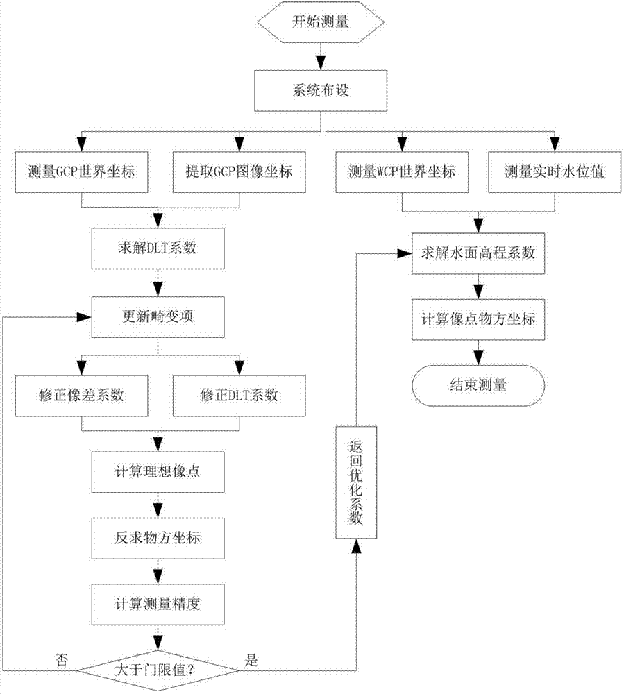
[0032] The technical scheme of the present invention is described in detail below in conjunction with accompanying drawing:

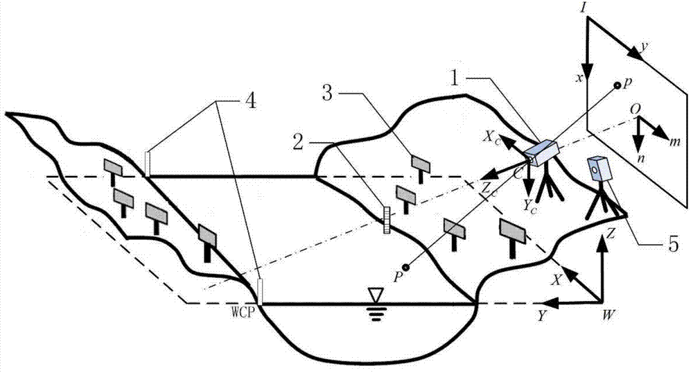
[0033] The coordinate system of river water surface photogrammetry among the present invention is as figure 1 shown. The coordinate system is based on a central perspective projection model. According to the needs of flow field calibration, the following four coordinate systems at different levels are defined: (1) The world coordinate system W-XYZ reflects the three-dimensional physical space where the measured scene and the camera are located. The establishment of the coordinate system mainly considers the application environment and object conditions. Here, the E-N-Z coordinate system of the total station can be directly used. The coordinates of the object point P are represented by (X, Y, Z), while the world coordinates of the camera optical center are represented by (X 0 ,Y 0 ,Z 0 )express. (2) Camera coordinate system C-X C Y C Z C , refle...


PUM


Abstract

The invention discloses a river surface photographic surveying method based on height-change homography. According to the method, a camera is erected on one side of a river bank to shoot a river surface at a gradient visual angle; firstly, 8 non-coplanar square opposite angle markers are uniformly and symmetrically distributed on the two sides of the river to serve as ground control points, the crossing points of marker posts and the water surface and the crossing point of a water gauge and the water surface are used as water control points, and a non-prism total station is adopted for measuring the world coordinates of the water control points; then the sub pixel image coordinates of the ground control points are attracted through a man-machine interaction way, and a DLT (direct linear transformation) factor and an optimized aberration coefficient are solved through direct linear transformation for aberration correction; next, water gauge image reading and water level value attracting are performed automatically through an image identification method, and the gradient coefficient and the water level coefficient are calculated by using the world coordinates of the water control points, so as to build a water surface elevation model; finally, water surface image point coordinates are converted to be object space coordinates by using a height-change homography relation, so as to accomplish fiver photographic surveying. According to the invention, the system distribution is simple, the cost is low, and the method is applicable to high-accuracy river surface photographic speed surveying.

Description

technical field [0001] The invention relates to a photogrammetry method, in particular to a river water surface photogrammetry method based on variable height homography, and belongs to the technical field of digital photogrammetry. Background technique [0002] Photogrammetry is a measurement method that measures the geometric parameters and motion parameters of the measured object in three-dimensional space by analyzing and calculating the images taken by the imaging system. The photographic imaging process is a mapping from a three-dimensional space to a two-dimensional image, and this mapping relationship from a high-dimensional space to a lower-dimensional space is projection. The gray value of the pixel in the image reflects the light intensity of the spatial point, and the image position of the pixel corresponds to the geometric position of the spatial point, and the corresponding relationship between the two positions is determined by the imaging model of the imaging...

Claims


Application Information

Patent Timeline
Patent Type & Authority Applications(China)
IPC IPC(8): G01C11/00
CPCG01C11/00Y02A90/30
Inventor 张振徐立中陈哲
Owner HOHAI UNIV
Why Eureka
Try Eureka