Atmospheric correction method for multi-spectral data of inland turbid water body based on green light wave band

An atmospheric correction, multi-spectral technology, applied in the field of remote sensing, can solve the problems of restricted application, wide band, and low atmospheric correction accuracy, and achieve the effects of improving atmospheric correction accuracy, improving estimation accuracy, and avoiding overcorrection.

Inactive Publication Date: 2014-02-05
李云梅
View PDF2 Cites 15 Cited by
  • Summary
  • Abstract
  • Description
  • Claims
  • Application Information

AI Technical Summary

Problems solved by technology

Since multispectral remote sensing data often have the characteristics of high spatial resolution, they are important data sources for remote sensing monitoring of inland water environments. TM sensor data, SPOT satellite data, my country's environment-1 satellite CCD data, etc.), the band is wide, and the lack of a special atmospheric correction band makes its atmospheric correction accuracy not high, which restricts its application in water environment remote sen

Method used


Image

  • Atmospheric correction method for multi-spectral data of inland turbid water body based on green light wave band
  • Atmospheric correction method for multi-spectral data of inland turbid water body based on green light wave band
  • Atmospheric correction method for multi-spectral data of inland turbid water body based on green light wave band

Examples


Embodiment

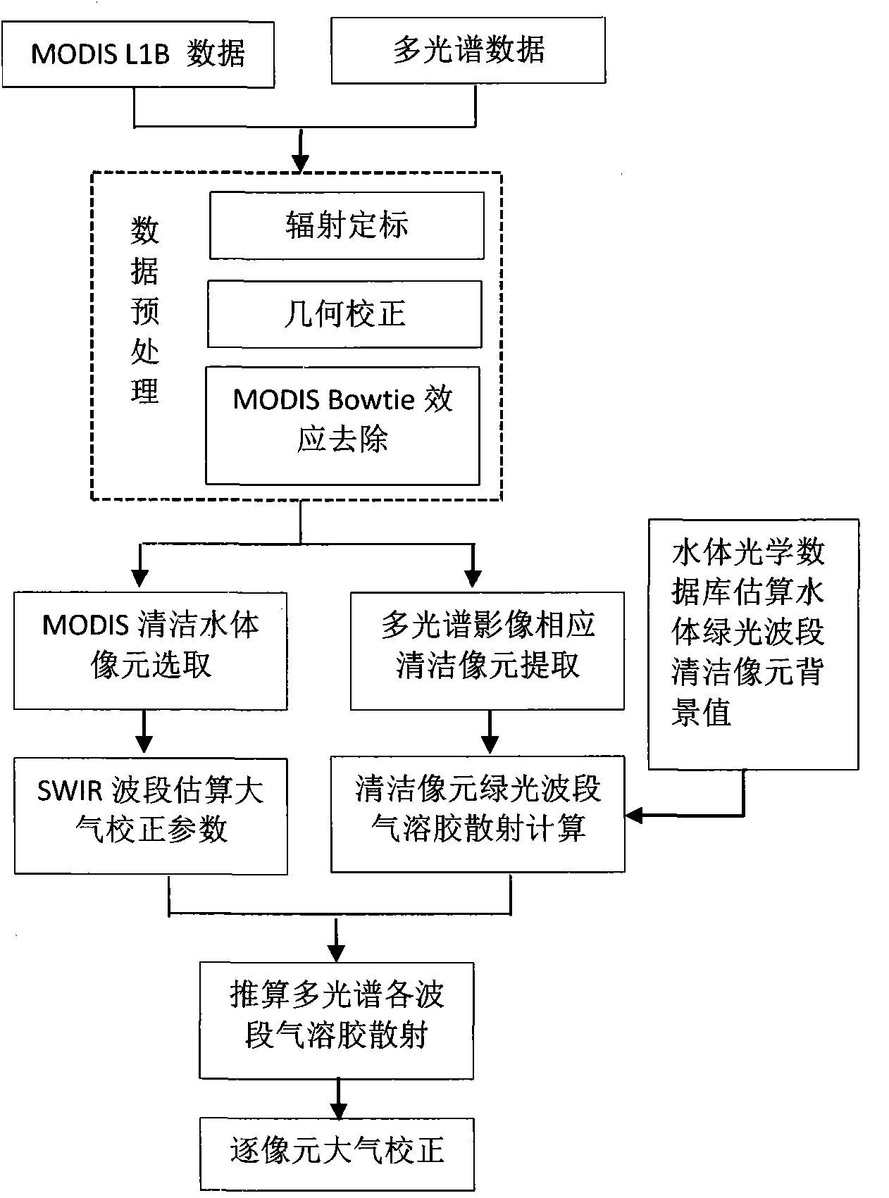
[0040] Example: In this example, the Taihu Lake is taken as an example of inland water body, and the CCD data of Environment-1 satellite and the MODIS data obtained synchronously are used as examples of multi-spectral remote sensing images, and the process of using the method for atmospheric correction of inland water body is described in detail . figure 1 It is the flow chart of the method for atmospheric correction of multispectral images of inland turbid water bodies based on the green light band according to the embodiment of the present invention, such as figure 1 Said, the method includes the steps:

[0041] A: The three-day environmental satellite CCD image data of April 17, 21, and 25, 2009 were obtained through the website, and the data was preprocessed, including: Taihu Lake water extraction, geometric correction, and radiometric calibration, including: Taihu Lake waters Extraction, geometric correction, radiometric calibration;

[0042] B: The MODIS L1B1km resolut...


PUM


Abstract

The invention discloses an atmospheric correction method for multi-spectral data of an inland turbid water body based on a green light wave band and relates to the technical field of remote sensing. The atmospheric correction method comprises the following steps: (A) preprocessing multi-spectral image data of an inland water body; (B) preprocessing a moderate-resolution imaging spectroradiometer (MODIS) L1B image which is synchronously acquired; (C) extracting clean pixels (dark pixels) from the preprocessed image data; (D) calculating an atmospheric correction factor through short-wave infrared (SWIR) band combination for MODIS data clean pixels; (E) calculating the water-leaving reflectivity of a clean water body green light wave band which is matched with a multi-spectral wave band according to an analog database and a great number of experiment observation data; (F) calculating the aerosol scattering of each wave band according to the atmospheric correction factor which is calculated in the step (D) and the water-leaving reflectivity which is calculated in the step (E); and (G) completing atmospheric correction of the multi-spectral image data according to the aerosol scattering which is calculated in the step (F). According to the method, the atmospheric correction accuracy of multi-spectral remote sensing data of the inland turbid water body is improved.

Description

technical field [0001] The invention relates to the field of remote sensing technology, in particular to an atmospheric correction method for multi-spectral data of inland turbid water bodies based on a green light band. Background technique [0002] Remote sensing technology is an important technical means for water environment monitoring and evaluation. Because multispectral remote sensing data often has the characteristics of high spatial resolution, it is an important data source for remote sensing monitoring of inland water environment. However, multispectral data usually only contains four bands of red, green, blue and near-infrared (such as Landsat TM sensor data, SPOT satellite data, CCD data of my country's Environment-1 satellite, etc.), the band is wide, and the lack of a special atmospheric correction band makes its atmospheric correction accuracy not high, which restricts its application in remote sensing monitoring of water environment . At present, the atmosph...

Claims


Application Information

Patent Timeline
IPC IPC(8): G01N21/55G01N21/25
Inventor 李云梅王桥朱利檀静
Owner 李云梅
Why Eureka
Try Eureka