Method for filtering out green vegetation data in ground laser radar scanning data

A terrestrial lidar, scanning data technology, applied in image data processing, instrument, character and pattern recognition and other directions, can solve the problems of subsequent processing interference of target data, the impact of complete acquisition of target point cloud data, etc., to solve the problem of holes, reduce Difficulty, effect of removing noise

Inactive Publication Date: 2014-02-19
BEIJING FORESTRY UNIVERSITY
View PDF2 Cites 9 Cited by
  • Summary
  • Abstract
  • Description
  • Claims
  • Application Information

AI Technical Summary

Problems solved by technology

However, whether it is a single scan or multiple scans, the green plants near the target not only affect the complete acquisition of the target point cloud data,

Method used


Image

  • Method for filtering out green vegetation data in ground laser radar scanning data
  • Method for filtering out green vegetation data in ground laser radar scanning data
  • Method for filtering out green vegetation data in ground laser radar scanning data

Examples


Embodiment Construction

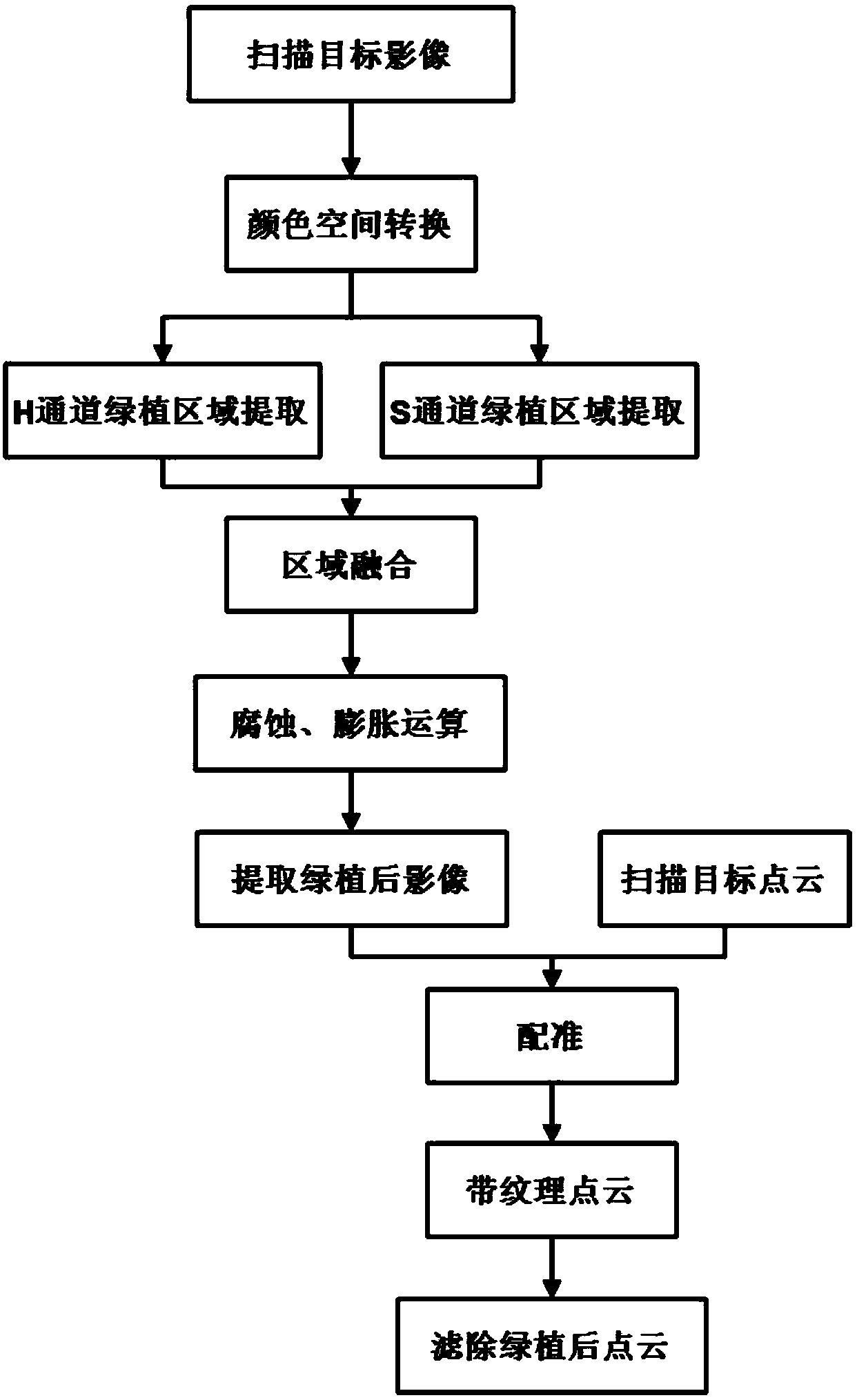
[0016] The present invention will be further described in detail with reference to the accompanying drawings and embodiments.

[0017] A method for filtering out green vegetation in ground lidar scanning data of the present invention, the process is as follows figure 1 shown, including the following steps:

[0018] (1) The ground lidar is equipped with a camera. When the ground lidar scans, the camera collects synchronously to obtain image data. Through color space conversion, the image data is converted from RGB color space to HLS color space;

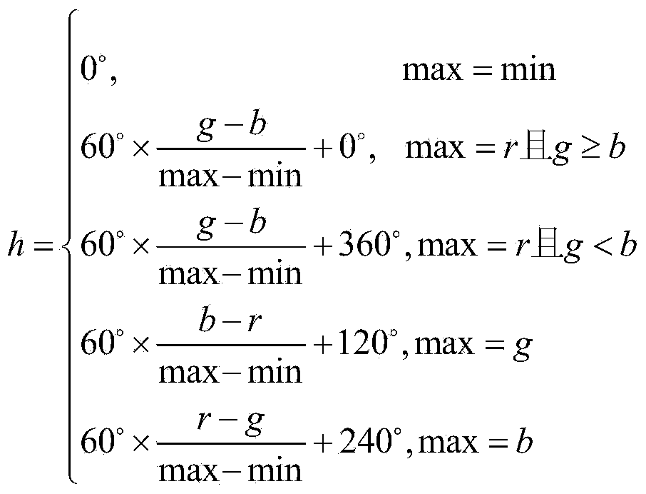
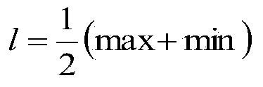
[0019] The conversion from RGB color space to HLS color space is performed by the following formula:

[0020]

[0021] l = 1 2 ( max + min )

[0022]

[0023] Among them, r represents the value of the red (R) channel in the RGB color space; g represents the value of the green (G) channel in...


PUM


Abstract

The invention provides a method for filtering out green vegetation data in point cloud data based on high-resolution image data. According to the method for filtering out the green vegetation data in the point cloud data based on the high-resolution image data, the characteristics of the point cloud data and the characteristics of the image data are analyzed; a method is put forward to conduct color spatial transformation on the image data, namely an ordinary RGB image is converted into an HLS image; a green vegetation coverage area in the image is extracted according to the hue and saturability, the binary-image erosion operation and dilation operation are conducted on the extracted area to eliminate noisy points, and then the registered point cloud data are filtered out according to an extraction result. The method for filtering out the green vegetation data in the point cloud data based on the high-resolution image data has the advantages that the difficulty of processing three-dimensional point cloud spatial data is lowered based on the two-dimensional image, the green vegetation area can be recognized effectively through conversion from the RGB color space to the HLS color space, and the problem of holes of the extracted area can be effectively solved through the binary-image erosion operation and the dilation operation.

Description

technical field [0001] The invention relates to the field of ground laser radar data processing, in particular to a method for filtering green vegetation in ground laser radar scanning data. Background technique [0002] Ground-based lidar has the characteristics of convenient use, fast measurement speed, and large amount of collected data. It can achieve very high accuracy in close-range measurement, and can obtain point cloud data containing fine three-dimensional structure information of scanned targets. After years of development, terrestrial lidar technology has matured and has been widely used in many fields, such as: geology and geological analysis, urban planning, forestry and vegetation analysis, etc. Since the information obtained by ground lidar contains precise and detailed target structure information, it is often used to reconstruct the target structure for planning and design, or to analyze the structural characteristics and changes of the target. Ground lida...

Claims


Application Information

Patent Timeline
IPC IPC(8): G06T7/40G06K9/46
Inventor 汪沛步国超
Owner BEIJING FORESTRY UNIVERSITY
Why Eureka
Try Eureka