Automatic extraction method for road information based on point cloud

A technology for automatic extraction and road information, applied in the directions of road network navigators, measuring devices, surveying and navigation, etc., can solve the problems of high accuracy and quality requirements, low survey and design work costs, low product accuracy, etc., to meet the data accuracy requirements. and density requirements, reduce project costs, and ensure the effect of personal safety

Active Publication Date: 2014-04-23
星际空间(天津)科技发展有限公司
View PDF6 Cites 37 Cited by
  • Summary
  • Abstract
  • Description
  • Claims
  • Application Information

AI Technical Summary

Problems solved by technology

[0006] (1) There are many shortcomings in engineering survey, such as heavy workload, high project cost, long operation period and high labor intensity, and great impact on existing road operation, which cannot meet the requirements of low cost, short construction period and high precision of survey and design by the highway management department. and high quality requirements and other practical requirements;
[0007] (2) Engineering survey requires field surveyors to work on the road. In order to meet the requirements of the survey work, one method is to temporarily close the survey section to ensure the safety of field surveyors, but this operation method seriously affects road transportation. The normal operation of the management department has had a relatively large negative impact on the normal operation of the economy and society; another method is not to close the expressway, and the operators work on the road surface, and only give warning reminders on the...

Method used


Image

  • Automatic extraction method for road information based on point cloud
  • Automatic extraction method for road information based on point cloud
  • Automatic extraction method for road information based on point cloud

Examples


Embodiment 1

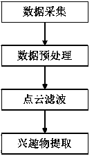
[0071] figure 1 A schematic flow chart of the method for automatically extracting road information based on point clouds provided in this embodiment, as shown in the figure, the method is as follows:

[0072] S1 data acquisition: After the selection of the ground GNSS base station and the calibration of the acquisition equipment are completed, the point cloud data is collected through the mobile platform;

[0073] S2 data preprocessing: preprocess the collected raw data and output the required point cloud data;

[0074] S3 point cloud filtering: filter point cloud data through filtering processing software, and obtain accurate point cloud classification results through automatic classification and partial human-computer interaction classification;

[0075] S4 Extraction of objects of interest: Use the filtered point cloud to extract ground object information and output it in the required format.

[0076] Such as Figure 5 As shown, the specific data collection process is as...

Embodiment 2

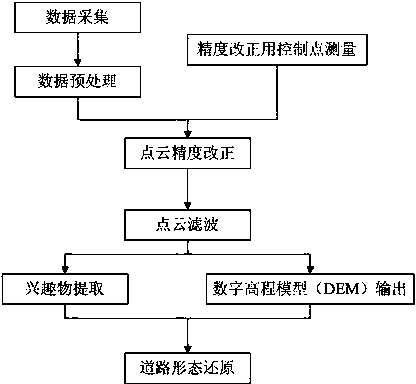
[0120] figure 2 A schematic flow chart of the method for automatically extracting road information based on point clouds provided in this embodiment, as shown in the figure, the method is as follows:

[0121] S1 data acquisition: After the selection of the ground GNSS base station and the calibration of the acquisition equipment are completed, the point cloud data is collected through the mobile platform;

[0122] S2 data preprocessing: preprocess the collected raw data and output the required point cloud data;

[0123] S3 point cloud accuracy correction control point measurement: In order to obtain higher-precision result data, it is necessary to lay out a certain number of control points on the road surface and measure them with the required accuracy level;

[0124] S4 point cloud accuracy correction: In order to meet the accuracy requirements of relevant data results, the accuracy of the preprocessed point cloud is corrected by using the road surface control points obtain...

Embodiment 3

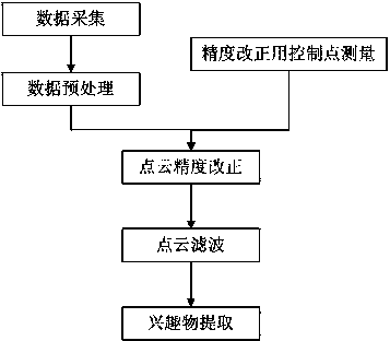
[0200] image 3 A schematic flow chart of the method for automatically extracting road information based on point clouds provided in this embodiment, as shown in the figure, the method is as follows:

[0201] S1 data acquisition: After the selection of the ground GNSS base station and the calibration of the acquisition equipment are completed, the point cloud data is collected through the mobile platform;

[0202] S2 data preprocessing: preprocess the collected raw data and output the required point cloud data;

[0203] S3 point cloud accuracy correction control point measurement: In order to obtain higher-precision result data, it is necessary to lay out a certain number of control points on the road surface and measure them with the required accuracy level;

[0204] S4 point cloud accuracy correction: In order to meet the accuracy requirements of relevant data results, the accuracy of the preprocessed point cloud is corrected using the road surface control points obtained f...


PUM


Abstract

The invention discloses an automatic extraction method for road information based on point cloud, and relates to the fields of mapping and road engineering design and management. The automatic extraction method comprises the following steps: data acquisition: after the selection of a GNSS (Global Navigation Satellite System) base station and the qualified check of acquiring equipment are finished, point cloud data is acquired through a mobile platform; data preprocessing: the acquired original data is preprocessed to output needed point cloud data; point cloud filtering: the point cloud data is filtered through filtering processing software, and accurate point cloud classifying achievements are obtained by the automatic classification and local human-computer interaction classification; interest extracting: the filtered point cloud is used for extracting ground feature information, and the ground feature information is output by the needed format. The automatic extraction method has the following advantages: the precise extraction of two-dimensional and three-dimensional road information is realized under the condition of not interrupting the normal traffic operation; the deep processing additional value of preliminary survey phase achievements is improved; the integration of preliminary survey and location survey operations of roads is realized; and the entire construction cost of projects is largely reduced.

Description

technical field [0001] The present invention relates to the field of surveying and mapping and road engineering design and management, in particular to a point cloud-based automatic road information extraction that can automatically obtain accurate two-dimensional and three-dimensional road information without interrupting traffic, and can replace manual road measurement method. Background technique [0002] A road can literally be described as a path leading from one place to another. In daily life, we tend to think of a road as a road for people, horses and vehicles; a passage between two places. However, with the development of social processes, roads have been endowed with new concepts. For example, the routes traveled by trains, the waterways operated by ships, and the infrastructure for vehicles and pedestrians can all be called different manifestations of roads. [0003] With the continuous and rapid development of social economy, the traffic volume of roads is incr...

Claims


Application Information

Patent Timeline
IPC IPC(8): G01C7/04G01C21/26
CPCG01C7/04
Inventor 田春来邓世军王国飞陈春明李建平周泽兵闫继扬
Owner 星际空间(天津)科技发展有限公司
Why Eureka
Try Eureka