Eureka AIR delivers breakthrough ideas for toughest innovation challenges, trusted by R&D personnel around the world.

Online open planning supporting method and system for dissimilar intelligent wireless sensors

A wireless sensor and intelligent technology, applied in wireless communication, network planning, electrical components, etc., can solve problems such as reducing development efficiency, increasing development difficulty, and difficult to achieve interoperability, reducing difficulty and complexity, improving convenience, To achieve the effect of sharing

Active Publication Date: 2014-04-23
WUHAN UNIV
View PDF4 Cites 1 Cited by
  • Summary
  • Abstract
  • Description
  • Claims
  • Application Information

AI Technical Summary

Problems solved by technology

[0005] (1) It is difficult to realize the planning and control of online heterogeneous intelligent wireless sensors in the Internet environment;
[0006] (2) Heterogeneous sensors or sensor networks often use different control technologies for control, making it difficult to achieve interoperability; on the other hand, in order to control the same sensor or sensor system, different clients often need to implement the entire control function module separately. Increased development difficulty and reduced development efficiency;
[0007] (3) It does not support the access and acquisition of observation data based on spatio-temporal location during the execution of planning tasks by intelligent wireless sensors

Method used


Image

  • Online open planning supporting method and system for dissimilar intelligent wireless sensors
  • Online open planning supporting method and system for dissimilar intelligent wireless sensors

Examples


Embodiment Construction

[0060] The Sensor Planning Service (SPS) developed by the Sensor Web Enablement (SWE) project team of the Open Geospatial Consortium (OGC) makes it possible to control and maintain the interoperability of data collection devices , to support the management of the collection process of the required data. It is designed to provide an interoperable Internet-based service through which clients can make judgments about the feasibility of network requests to collect data from one or more sensors / platforms, or clients can directly send These sensors or platforms submit data collection requests. SPS provides a set of standard and open interfaces for collection devices (eg, sensors, and other information collection devices) and surrounding systems that support these collection devices. SPS operations are divided into information operations and functional operations. Information operations include GetCapabilities, DescribeTasking, DescribeResultAccess, and GetStatus. Among them, the G...


PUM


Abstract

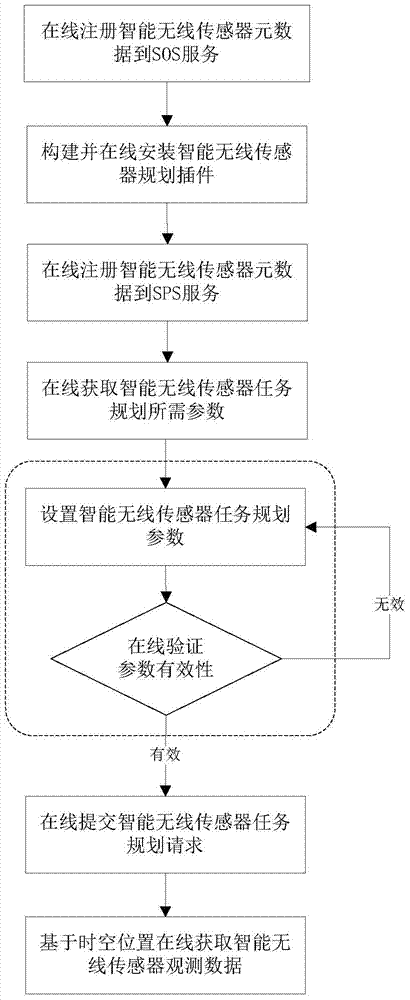
The invention discloses an online open planning supporting method and an online open planning supporting system for dissimilar intelligent wireless sensors. The method comprises the following seven steps of registering the metadata of the intelligent wireless sensors to SOS (sensor observation service) on line through the Internet, constructing and on line installing an intelligent wireless sensor planning plug-in, registering the metadata of the intelligent wireless sensors to SPS (sensor planning service) on line, acquiring the task planning parameter description of the intelligent wireless sensors on line, setting task planning parameters of the intelligent wireless sensors, verifying the validity of the task planning parameters of the intelligent wireless sensors on line, submitting an intelligent wireless sensor task planning request on line and acquiring the observation data of the intelligent wireless sensors on line based on time-space positions. According to the method and the system, tasks of the dissimilar intelligent wireless sensors are openly planned on line in an Internet environment, so that support is provided for the interoperation of control of the dissimilar intelligent wireless sensors and the active and demand-based observation of the dissimilar intelligent wireless sensors, and meanwhile, the convenience and the openness of data collection management of the dissimilar intelligent wireless sensors are improved.

Description

technical field [0001] The invention relates to the technical field of smart city sensor planning and control, in particular to a method and system for supporting online open planning of heterogeneous smart wireless sensors. [0002] Background technique [0003] The construction of a smart earth has become the focus of developed countries and some developing countries in formulating their own development strategies. Smart Earth, also known as Smart Earth, is to embed and equip sensors into various objects such as power grids, railways, bridges, tunnels, highways, buildings, water supply systems, dams, oil and gas pipelines, etc., to perceive various changes in the real world in real time. And it is widely interconnected to form the so-called "Internet of Things", and then integrate the "Internet of Things" with the existing Internet to realize the integration of human society and physical systems. As an important sensor in the smart earth, smart wireless sensors can measu...

Claims


Application Information

Patent Timeline
Patent Type & Authority Applications(China)
IPC IPC(8): H04W16/18
Inventor 陈能成肖长江卜方玲王智莉
Owner WUHAN UNIV
Why Eureka
Eureka Blog
Learn More