Spatial data processing method and system

A technology of spatial data and processing methods, which is applied in the fields of electrical digital data processing, special data processing applications, and redundant data error detection in calculations. It can solve the problems of low synchronous replication performance of spatial databases, expensive distributed databases, Lack of space parallel mechanism and other issues to achieve high-performance parallel computing, avoid single point of failure, and save computing costs

Active Publication Date: 2014-05-14
BEIJING SUPERMAP SOFTWARE CO LTD
View PDF4 Cites 18 Cited by
  • Summary
  • Abstract
  • Description
  • Claims
  • Application Information

AI Technical Summary

Problems solved by technology

Disadvantages: low synchronous replication performance of spatial database; expensive distributed database, high operation and maintenance deployment cost; distributed granularity is limited by the E-R model, parallel based on table and record mode, lack of spatial parallel mechanism, and low efficiency

Method used


Image

  • Spatial data processing method and system
  • Spatial data processing method and system
  • Spatial data processing method and system

Examples


Embodiment Construction

[0052] In order to make the above objects, features and advantages of the present invention more comprehensible, the present invention will be further described in detail below in conjunction with the accompanying drawings and specific embodiments.

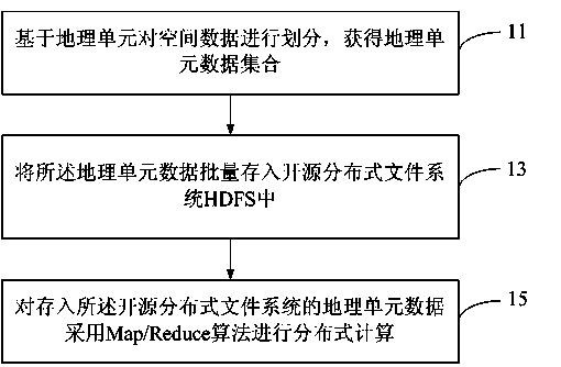
[0053]Before introducing the technical solution of the present invention, it is necessary to briefly understand the concept of parallel data processing. For massive data sets, in order to obtain efficient query results, the massive data sets can be horizontally segmented and placed in multiple storage databases, and then Query requests are distributed to these database engines, query results are obtained in parallel, and then these results are combined to obtain actual results.

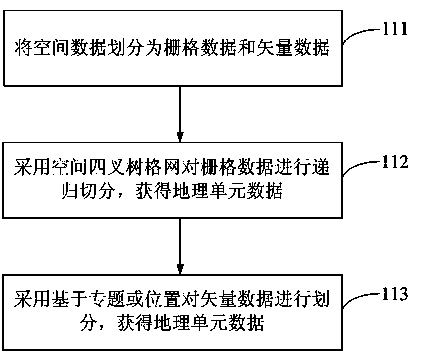
[0054] The invention provides a method for parallel data processing of spatial data. In view of the massive characteristics of spatial data, spatial computing is more complicated, which can be divided into data-intensive, computing-intensive, and network-...


PUM


Abstract

The invention provides a spatial data processing method and system. The spatial data processing method includes acquiring a geographic unit data set on the basis of dividing spatial data by geographic units; storing the geographic unit data set to an open source distribution type file system in batches; performing distribution type computing on the geographic unit data set stored in the open source distribution type file system by the Map / Reduce algorithm. By the aid of the spatial data processing method, a task can be divided into a plurality of tasks to be processed simultaneously, high-performance parallel computing is achieved; since the open source distribution type file system and the Map / Reduce algorithm are adopted, high-performance computing of geographic information can be supported by using an ordinary computer and computing model, and the method has the advantages of high adaptability and low cost.

Description

technical field [0001] The present invention relates to the technical field of spatial data processing, in particular to a method and system for processing spatial data. Background technique [0002] Spatial data refers to the data used to represent the position, shape, size and distribution characteristics of spatial entities. At present, spatial data such as remote sensing images, aerial surveys, basic surveying and mapping, and sensor networks present the characteristics of a large amount of data generated at a time, a short generation cycle, and a large amount of overall data. [0003] Based on the massive characteristics of the above-mentioned spatial data, spatial computing also presents complex characteristics. The complexity of spatial computing can be divided into data-intensive, computing-intensive, and network-intensive, among which data-intensive is the most, such as optics, geometric correction of remote sensing images, rasterization of vector data, etc., on t...

Claims


Application Information

Patent Timeline
Patent Type & Authority Applications(China)
IPC IPC(8): G06F17/30G06F11/14
CPCG06F16/29
Inventor 黄骞王尔琪滕寿威
Owner BEIJING SUPERMAP SOFTWARE CO LTD
Why Eureka
Try Eureka