Method for realizing high-precision location based on Big Dipper system civil carrier phase combination

A carrier phase, high-precision technology, used in radio wave measurement systems, satellite radio beacon positioning systems, measurement devices, etc., can solve the problem of difficult to quickly solve the ambiguity of the whole circle, and the inability to directly use Beidou civilian services.

Active Publication Date: 2014-06-04
ACAD OF OPTO ELECTRONICS CHINESE ACAD OF SCI
View PDF5 Cites 32 Cited by
  • Summary
  • Abstract
  • Description
  • Claims
  • Application Information

AI Technical Summary

Problems solved by technology

[0004] One is the special constellation configuration of the Beidou system, especially the relatively fixed spatial position of the GEO (Geostationary Orbit) satellites in the constellation. The existing method for determining the ambiguity of the entire circle proposed based on the GPS system is difficult to be directly applied to the GEO satellites and realize its overall ambiguity. The fast solution of the surrounding ambiguity needs to propose a new method to solve this problem
[0005] Second, the Beidou system regional service only provides two frequencies in the L-band for civilian users, and the triple-frequency carrier phase combination high-precision positioning technology cannot be directly used for Beidou civilian services

Method used


Image

  • Method for realizing high-precision location based on Big Dipper system civil carrier phase combination
  • Method for realizing high-precision location based on Big Dipper system civil carrier phase combination
  • Method for realizing high-precision location based on Big Dipper system civil carrier phase combination

Examples


Embodiment Construction

[0083] In order to make the object, technical solution and advantages of the present invention clearer, the present invention will be described in further detail below in conjunction with specific embodiments and with reference to the accompanying drawings.

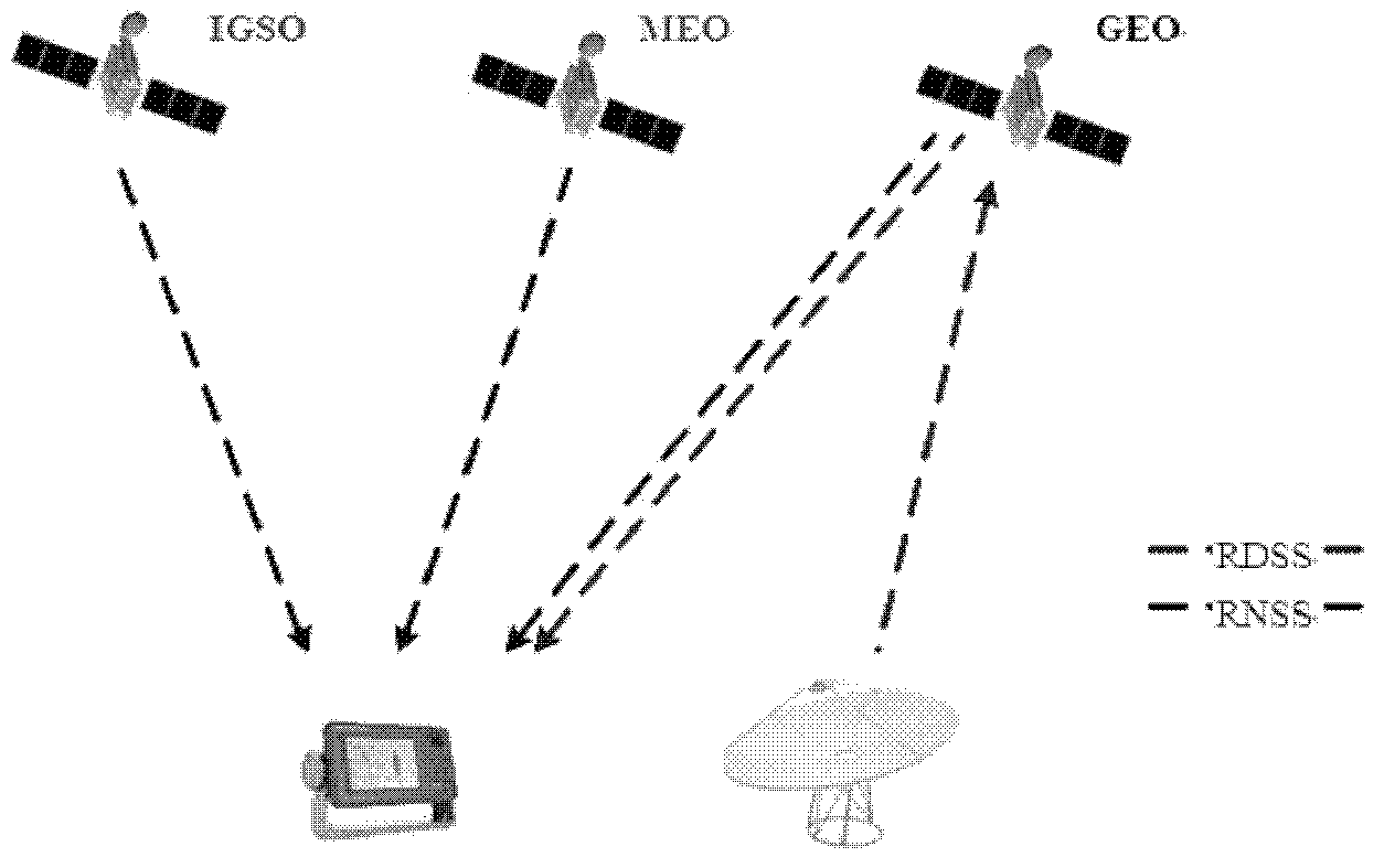
[0084] In view of the fact that the civil frequency of the Beidou RNSS system is dual-frequency, which limits the reliability of fast and even single-epoch carrier phase positioning, this invention makes full use of the characteristics of the Beidou system and the frequency configuration in civil services, and proposes for the first time that the RNSS+RDSS multi-frequency carrier combination is fast and high-speed. precision method.

[0085] The Beidou system is characterized by providing two services, RDSS and RNSS. The RDSS provides the radio determination satellite service (Radio Determination Satellite Service), and the RNSS provides the radio positioning service (Radio Navigation Satellite System). According to the ...


PUM


Abstract

The invention discloses a method for realizing high-precision location based on Big Dipper system civil carrier phase combination. The method comprises the steps of calculating the original user position and utilizing the original user position to calculate the GEO superwide lane whole circle ambiguity; taking the integer of the observed quantity of GEO superwide lane combination, calculating the GEO wide lane whole circle ambiguity (img file='DDA00002471851000011.TIF' wi='160' he'='47'/), calculating the error of double difference observed quantity of the GEO superwide lane combination, and determining the searching range of the ambiguity of a GEO wide lane; conducting dimensionality reduction search on the GEO wide lane whole circle ambiguity (img file='DDA00002471851000012.TIF' wi='134' he'='47'/) to obtain the accurate value of the GEO wide lane whole circle ambiguity; selecting an MEO/IGSO satellite to initially calculate the wide lane whole circle ambiguity; utilizing the ambiguity combined relationship between a superwide lane and a wide lane to obtain the double difference ambiguity on a B1 frequency point, a B2 frequency point and an S frequency point; utilizing the sum of the double difference ambiguity on the B1 frequency point, the B2 frequency point and the S frequency point to receive carrier phase of machine measurement and conduct planet base double difference location, and calculating the high precision position of a user. Through the method, the purpose of quick high precision location of Big Dipper carrier phases is achieved.

Description

technical field [0001] The invention relates to the technical field of satellite navigation high-precision positioning, in particular to a method for realizing decimeter-level or even centimeter-level high-precision positioning based on Beidou system civil carrier phase combination. Background technique [0002] With the development of global GNSS technology, the demand for high-precision application of carrier phase single epoch has driven the rapid development of carrier phase high-precision positioning. The key to carrier phase high-precision positioning solution is the resolution of integer ambiguity. For integer ambiguity resolution, the most widely used methods in recent years include least squares ambiguity decorrelation adjustment algorithm (LAMBDA method), TCAR (Three Carrier Ambiguity Resolution), CAR (Cascade Integer Resolution) and so on. Among them, TCAR is a three-frequency ambiguity resolution method. This method cleverly uses three frequencies to form a sup...

Claims


Application Information

Patent Timeline
Patent Type & Authority Applications(China)
IPC IPC(8): G01S19/44
CPCG01S19/44
Inventor 曲江华袁洪欧阳光洲赵姣姣
Owner ACAD OF OPTO ELECTRONICS CHINESE ACAD OF SCI
Why Eureka
Try Eureka