Method used for gully erosion extraction based on landform and remote sensing image fusion technology

A technology of remote sensing images and remote sensing images, which is applied in the field of remote sensing and can solve problems such as the loss of spectral information of remote sensing images

Inactive Publication Date: 2014-07-23
LUDONG UNIVERSITY
View PDF5 Cites 16 Cited by
  • Summary
  • Abstract
  • Description
  • Claims
  • Application Information

AI Technical Summary

Problems solved by technology

[0005] The purpose of the present invention is to overcome the deficiencies of the above-mentioned prior art, and provide a method for extracting gullies based on terrain and remo

Method used


Image

  • Method used for gully erosion extraction based on landform and remote sensing image fusion technology

Examples


Embodiment 1

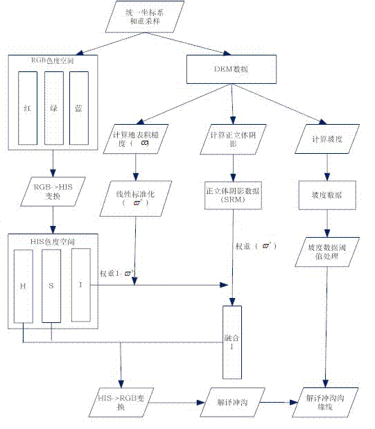
[0040] Example 1, see figure 1 In the first step, first, in the research area, the optical remote sensing image RGB three-band remote sensing image and DEM data coordinate system are unified into Gauss-Krog's plane rectal coordinate system, and the two have the same space to distinguish the same space distortionRate;

[0041] The second step, the HIS transformation of the RGB three -color band of the remote sensing image is used to obtain the hue Saturation Brightness Three -meter data;

[0042] The third step, according to DEM data, combined with the remote sensing image imaging time (year, day, seconds, seconds), the center of the image center point of the latitude and longitude coordinates, calculate the imaging moment of the sun orientation angle Height corner of the sun It

[0043] The fourth step, based on DEM data, calculates the surface roughness, obtains the surface roughness data And linear standardization processing (formula 2), obtain linear standardized surface ...


PUM


Abstract

The invention provides a method used for gully erosion extraction based on landform and remote sensing image fusion technology. The method is based on conversion between remote sensing RGB (red, green, and blue) color space and HIS (hue, intensity, and saturation) color space; linear standard surface roughness omega<-><'> is taken as weight of sun northwest shaded relief model (SRM); 1-omega<-><'> is taken as color intensity component weight; novel color intensity component I' is obtained via summation; conversion from HIS color space to RGB color space is performed based on the novel color intensity image I', and fusion of landform information and remote sensing image is realized, so that gullies are represented by recesses, and peaks are represented by convexes in remote sensing images; and interpretation on gully shoulder lines is carried out base on fused remote sensing images, and via combination with gully shoulder line gradient threshold data which is obtained via calculation based on DEM (digital elevation model). Compared with traditional remote sensing image-based gully interpretation method, the method is capable of providing remote sensing two-dimensional images with landform information according with human visual habits, gully bottom remote sensing image characteristics are clear, and gully shoulder line interpretation accuracy is high.

Description

Technical field: [0001] The present invention involves the field of remote sensing technology. Specifically, it is a extraction that applies terrain information and remote sensing image fusion technology to the edge of Yonggou.The invention can be used for optical remote sensing images to perform ditch interpretation, ditch erosion research and drawing. Background technique: [0002] Chonggou erosion is an important way to erode. It is not only an important process that leads to land degeneration, but also a major source of rivers and sediment.At present, scholars at home and abroad mainly use the ground manual measurement method (CASALI et al., 2006; vandekerckhove et al., 2001;), Extract needle (pile) monitoring method (IONITA et al., 2006; Martinez et al.2003), RTK-GPS measurement method (He Fuhong et al., 2005; YOUGQIUWU et al., 2005), aviation film and digital high -primary modelEvolution.Since the emergence of aviation photography technology in the early 1960s, remote sensi...

Claims


Application Information

Patent Timeline
IPC IPC(8): G01C11/00
CPCG01C11/04G01S7/4802
Inventor 王涛何福红蒋卫国顾丽娟张振华
Owner LUDONG UNIVERSITY
Why Eureka
Try Eureka