Pulsar/starlight angle combination navigation method of high orbit satellite

A technology of starlight angular distance and high-orbit satellites, which is applied in the field of navigation and can solve the problems that high-orbit satellites are difficult to achieve autonomous positioning.

Inactive Publication Date: 2014-08-27
NAT UNIV OF DEFENSE TECH
View PDF2 Cites 19 Cited by
  • Summary
  • Abstract
  • Description
  • Claims
  • Application Information

AI Technical Summary

Problems solved by technology

[0006] The technical problem to be solved by the present invention is: aiming at the problem that the current high-orbit satellites are difficult to realize autonomous positioning, the auton

Method used


Image

  • Pulsar/starlight angle combination navigation method of high orbit satellite
  • Pulsar/starlight angle combination navigation method of high orbit satellite
  • Pulsar/starlight angle combination navigation method of high orbit satellite

Examples


Embodiment Construction

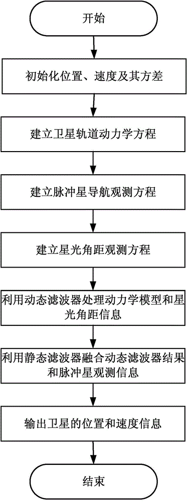
[0096] Such as figure 1 As shown, an autonomous navigation algorithm for medium and high orbits based on pulsar and starlight angular distance, the specific implementation steps are as follows:

[0097] (1) Establish orbital dynamics equations for near-Earth satellites;

[0098]In the geocentric inertial system J2000.0, the orbital dynamics equation of the near-Earth satellite is established as

[0099]

[0100] Among them, x=[r T ,v T ] T is the state vector of the spacecraft, w=[w r T w v T ] T is dynamic model noise, which can be modeled as zero-mean white Gaussian noise. The variance matrix of this noise is Q. a=a TB +a NS +a T +a H.O.T is the acceleration experienced by the spacecraft, including the following items.

[0101] 1)a TB =-μ E r / |r| 3 is the two-body gravitational acceleration of the spacecraft, where μ E is the gravitational constant of the earth.

[0102] 2) is the non-spherical gravitational perturbation of the earth. UNSE can be e...


PUM


Abstract

The invention discloses a pulsar/starlight angle combination navigation method of a high orbit satellite. The method comprises the following steps: establishing an orbital dynamic equation of a near earth satellite; establishing a pulsar navigation observation equation; establishing a starlight angle observation equation; using a dynamic filter to process a dynamic model and starlight angle distance information; and fusing the obtained filter result with the pulsar observation information by using a static filter. The combination navigation method uses the dynamic and static nonlinear filter to realize the optimal fusion of the original observation information of the pulsar with the starlight angle distance information, so compared with a pulsar navigation system, a combination navigation system has the advantages of small size, less power consumption short measurement period; and compared with CNS, the combination navigation system can obtain high precision navigation information.

Description

technical field [0001] The invention mainly relates to the field of navigation methods, in particular to a high-orbit satellite pulsar / starlight angular-distance combined navigation method. Background technique [0002] High-orbit satellites (orbit altitudes above 20,000km) play an important role in climate detection, disaster warning, and data relay. Accurate position information is an important factor to ensure the effective work of high-orbit satellites. At present, the orbit determination of high-orbit satellites is mostly based on ground measurement and control stations. However, with the increase in the number of high-orbit satellites, the burden on ground monitoring and control stations is gradually increasing. At the same time, the increasingly complex space environment also puts forward an urgent demand for the autonomy of high-orbit satellites. Having a highly reliable and stable autonomous navigation system is a necessary prerequisite for realizing the autonomy...

Claims


Application Information

Patent Timeline
IPC IPC(8): G01C21/02
CPCG01C21/24
Inventor 郑伟王奕迪汤国建张大鹏
Owner NAT UNIV OF DEFENSE TECH
Why Eureka
Try Eureka