A navigation ship altitude measurement system and its measurement method

An altitude measurement and ship technology, applied in the field of machine vision technology and GPS positioning, can solve problems such as technical difficulty, high installation requirements, endangering the lives of crew members, etc. Effect

Active Publication Date: 2016-07-06
DALIAN MARITIME UNIVERSITY
View PDF5 Cites 0 Cited by
  • Summary
  • Abstract
  • Description
  • Claims
  • Application Information

AI Technical Summary

Problems solved by technology

[0002] With the development of our country's national economy, the demand for traffic construction is getting higher and higher, which makes the demand for building bridges on navigable rivers increase day by day. The newly built bridges bring great convenience to the traffic on both sides of the strait, but at the same time, some When the bridge was originally designed, the bridge height, bridge width, and site selection did not fully take into account the future shipping needs, making some bridges unable to meet the navigation requirements of existing ships, and insufficient reserve heights made ships collide with bridges due to their super high height Accidents happen from time to time, and once the ship passes the bridge at super high altitude, it will often cause serious consequences, which not only threatens the safety of the ship itself, endangers the lives of the crew, but also affects the smooth flow of the entire channel and the safety of other navigable ships, which is extremely harmful
At present, the domestic superelevation detection technology is relatively backward, and most of them are based on the introduction of foreign superelevation detection systems and equipment, and most of these equipment focus on the research of superelevation detection methods based on lasers, but the laser detection method is actually a A height limit method can alarm ships higher than a certain height, but the actual height of the ship cannot be obtained, and the height limit method needs to change the height limit height according to the change of the water level, and the effect is not good when the distance from the river bank is large. Not very good
[0003] At present, there is another method of height measurement that uses image processing to obtain the height of the target by using machine vision. This method itself is mainly used to measure spatial position information, not for ship height measurement, and it is technically difficult and requires high equipment.
Moreover, this method itself is not for ship height measurement, but also has problems for ship height measurement, that is, the camera needs to be calibrated before it can measure the height, and after calibration, the parameters of the camera cannot be changed, so that the requirements for the camera and the installation are very difficult. have higher requirements

Method used


Image

  • A navigation ship altitude measurement system and its measurement method
  • A navigation ship altitude measurement system and its measurement method
  • A navigation ship altitude measurement system and its measurement method

Examples


Embodiment Construction

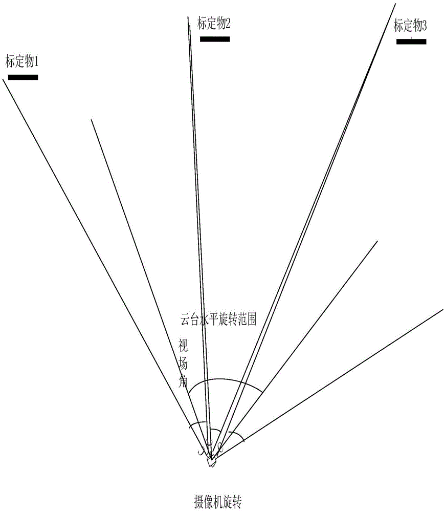
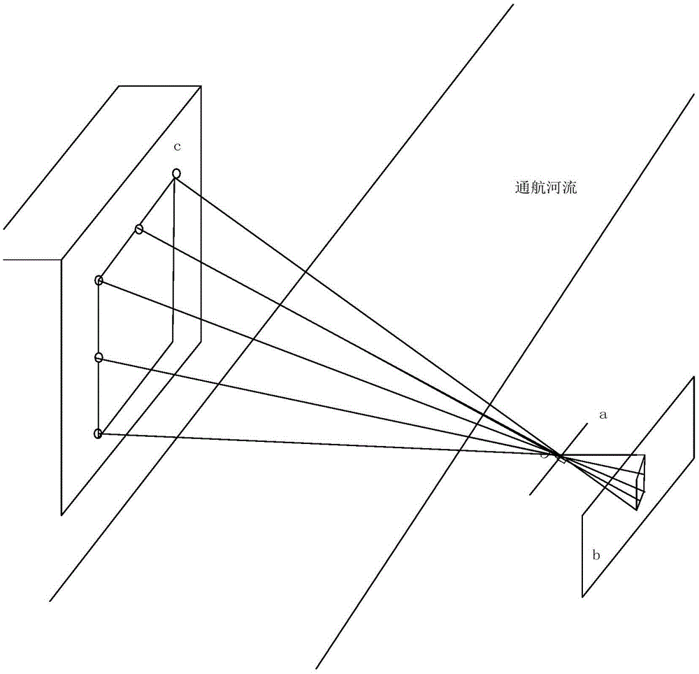
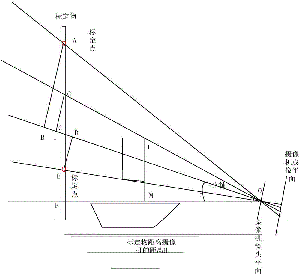
[0045] The present invention will be further described below in conjunction with the accompanying drawings. Such as Figure 11Shown, a kind of height measuring system of sailing ship, comprises calibration object 11, position information measuring module 12, cloud platform 1, video camera 3, computer 10, wireless transceiver module 8 and water level measuring module 9, is installed in the described computer 10 Cloud platform control module 2, image processing module 4, ship GPS calculation module 5, ship height measurement module 7 and calibration point parameter calculation module 6, described position information measurement module 12 measures the GPS information of calibration object 11 and relevant angular distance information, and the measurement results are input to the ship's GPS calculation module 5, and the described calibration point parameter calculation module 6 is connected with the ship's GPS calculation module 5 and the ship's height measurement module 7 respecti...


PUM


Abstract

The invention discloses a system and method for measuring the height of a navigation ship. The system comprises a position information measurement module, a camera, a computer, a wireless receiving and dispatching module and a water level measurement module, wherein a console control module, an image processing module, a ship GPS calculation module, a ship height measurement module and a fixed point parameter calculation module are installed in the computer. On the basis of an image processing machine vision method and the space geometry relation, only the camera, a fixed object and the computer need to be connected relatively in the installation process, installation is convenient, large equipment is not required, and maintenance is convenient; in addition, for an algorithm, the height of the ship above water is calculated out according to GPS information of the ship, angle information obtained through the console control module, background fixed point information and relative spatial position information. By means of the system and method for measuring the height of the navigation ship, design difficulty is reduced, and the requirement for measurement of height of the ship can be well met; the sight range of the camera is allowed to be adjusted, so that practicability is better.

Description

technical field [0001] The invention relates to machine vision technology, GPS positioning technology and a method for detecting the height of a sailing ship, in particular to a height measuring system and a measuring method for a sailing ship. Background technique [0002] With the development of our country's national economy, the demand for traffic construction is getting higher and higher, which makes the demand for building bridges on navigable rivers increase day by day. The newly built bridges bring great convenience to the traffic on both sides of the strait, but at the same time, some When the bridge was originally designed, the bridge height, bridge width, and site selection did not fully take into account the future shipping needs, making some bridges unable to meet the navigation requirements of existing ships, and insufficient reserve heights made ships collide with bridges due to their super high height Accidents happen from time to time, and once the ship pass...

Claims


Application Information

Patent Timeline
Patent Type & Authority Patents(China)
IPC IPC(8): G01B11/04
Inventor 熊木地张同斌黄喆张亚冲王璇
Owner DALIAN MARITIME UNIVERSITY
Why Eureka
Try Eureka