Radar remote sensing multi-scale surface roughness measuring method based on three-dimensional microtopography reconstruction

A surface roughness and measurement method technology, applied in the field of radar remote sensing multi-scale surface roughness measurement, can solve the problems of low measurement efficiency, inconvenient handling process, and high instrument requirements, achieve flexibility, convenience and practicability, suitable for popularization and application, measurement high precision effect

Inactive Publication Date: 2014-09-24
INST OF REMOTE SENSING & DIGITAL EARTH CHINESE ACADEMY OF SCI
View PDF2 Cites 10 Cited by
  • Summary
  • Abstract
  • Description
  • Claims
  • Application Information

AI Technical Summary

Problems solved by technology

The correlation length in the case of a 30m measurement section is often larger; in addition, the roughness may change at different wavelength observation scales
If you want to measure the roughness of 30m or more, you need to continue splicing, and the splicing process will undoubtedly bring non-negligible errors;
[0012] (2) The scale effect of the measurement results of the touch stylus roughness meter and the laser scanner is not obvious, it depends on the spacing of the stylus and the detection density of the scanner, that is, we cannot use the existing measurement technology to obtain the research area at the same time. Roughness on different wavelength scales such as band-L band;
[0013] (3) The existing three methods can only measure the "line roughness" in a certain direction, and the measurement of the regional "surface roughness" in this direction cannot be completed, which is very important for the new imaging mode of modern radar satellites. inapplicable
However, the requirements for the instrument are high, the cost is relatively expensive, and due to the complexity of the instrument, it is inconvenient during the handling process and the measurement efficiency is low, which is not conducive to actual measurement

Method used


Image

  • Radar remote sensing multi-scale surface roughness measuring method based on three-dimensional microtopography reconstruction
  • Radar remote sensing multi-scale surface roughness measuring method based on three-dimensional microtopography reconstruction
  • Radar remote sensing multi-scale surface roughness measuring method based on three-dimensional microtopography reconstruction

Examples


Embodiment Construction

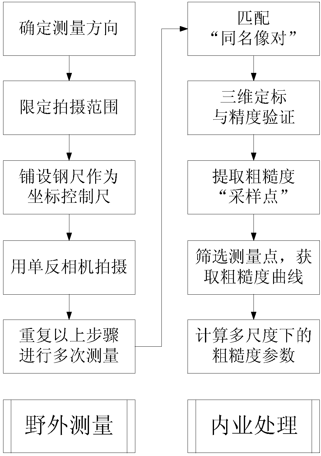
[0064] The preferred embodiments of the present invention will be described below in conjunction with the accompanying drawings. It should be understood that the preferred embodiments described here are only used to illustrate and explain the present invention, and are not intended to limit the present invention.

[0065] The invention mainly includes two parts of field measurement and office processing.

[0066] Below, combine figure 1 The specific steps of the invention are described:

[0067] (I) field measurement:

[0068] Step I-1 determines the measurement direction, that is, determines the azimuth direction

[0069] Use the compass in the area of ​​interest to determine the direction in which the roughness needs to be measured;

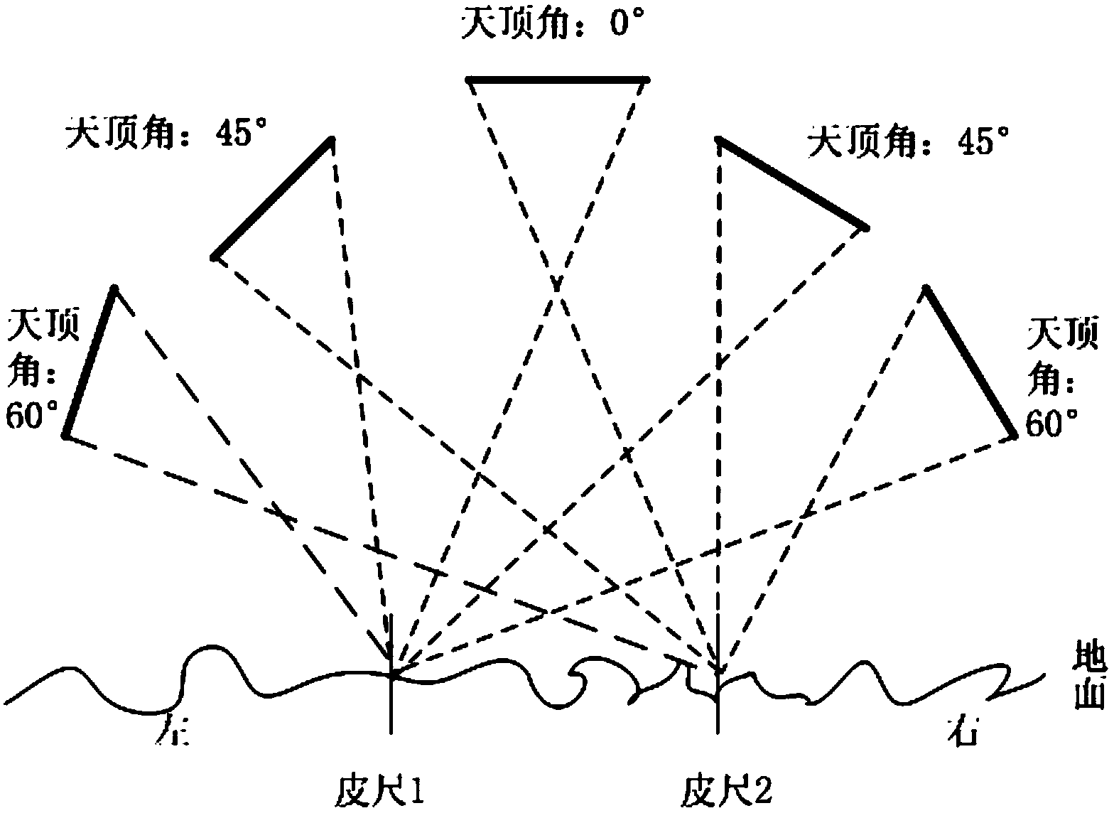
[0070] Step I-2 Limit shooting range

[0071] Along the direction indicated by the compass, pull the two measuring tapes in parallel for about 35m, and the distance between the two measuring tapes is about 50-70cm;

[0072] Step I-3 Lay st...


PUM

PropertyMeasurementUnit
Overlap degreeaaaaaaaaaa

Abstract

The invention discloses a radar remote sensing multi-scale surface roughness measuring method based on three-dimensional microtopography reconstruction. The method comprises the following steps: (I) field measurement: (I-1) determining the direction of measurement, (I-2) limiting the shooting range, (I-3) laying coordinate control rulers, (I-4) shooting images, and (I-5) repeating (I-1) to (I-4) to carry out measurement repeatedly; (II) interior work processing: (II-1) matching image pairs with the same name, (II-2) carrying out three-dimensional calibration and precision validation, (II-3) extracting roughness sampling points, (II-4) selecting measurement points and working out a roughness curve, and (II-5) calculating roughness parameters in multiple scales. By means of the method, the roughness of a large earth surface can be measured, the roughness of a survey region in different wave length scales can be obtained, and regional surface roughness measurement can be achieved. The method has the advantages of being high in measurement accuracy, high in efficiency, flexible and convenient to implement and high in practicality, thereby being suitable for application and popularization.

Description

technical field [0001] The invention relates to the technical field of roughness measurement, in particular to a radar remote sensing multi-scale surface roughness measurement method based on three-dimensional micro-topography reconstruction. Background technique [0002] Soil roughness has important applications in agriculture, soil science, weather and climate prediction, geology and other application fields. In agriculture and soil science, roughness affects infiltration, flooding, and soil erosion processes; in climate and weather forecasting, soil storage and evaporation of water also depend on soil roughness; in geology, surface The roughness can be used to determine the geological element information of wind-eroded sandstone. [0003] At present, radar remote sensing, as a new, advanced, practical, and large-scale surface observation method, is playing an increasingly important role in various application fields such as agriculture, soil, climate, and geology. Looki...

Claims


Application Information

Patent Timeline
Patent Type & Authority Applications(China)
IPC IPC(8): G01S13/88G01N22/00
CPCG01C7/02G01C11/08
Inventor 杨知宫华泽王龙飞邵芸柴勋
Owner INST OF REMOTE SENSING & DIGITAL EARTH CHINESE ACADEMY OF SCI
Why Eureka
Try Eureka