Retrieval method of remote sensing images

A remote sensing image and remote sensing image technology, applied in the field of remote sensing, can solve problems such as large amount of calculation, powerlessness, and heavy workload of human labeling, and achieve good effect of dimensionality reduction, improved scalability, and high retrieval accuracy

Inactive Publication Date: 2014-10-22
KUNSHAN HONGHU INFORMATION TECH SERVICE
View PDF2 Cites 6 Cited by
  • Summary
  • Abstract
  • Description
  • Claims
  • Application Information

AI Technical Summary

Problems solved by technology

[0004] The traditional remote sensing image retrieval system is mainly based on the metadata of remote sensing images, the underlying visual features or semantic annotation to achieve the retrieval function, but when faced with the mass of high-resolution remote sensing images, due to the large amount of calculation or manual annotation workload It seems powerless, unable to take into account timeliness and accuracy

Method used


Image

  • Retrieval method of remote sensing images
  • Retrieval method of remote sensing images
  • Retrieval method of remote sensing images

Examples


Embodiment 1

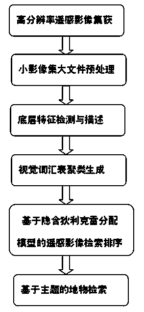
[0037] A retrieval method for remote sensing images, such as figure 1 As shown in the flowchart, the specific retrieval steps are as follows:

[0038] Step 1: Acquisition of high-resolution remote sensing image sets, through academic research applications for free download or data purchase, obtain high-resolution remote sensing image datasets and store them in high-performance platforms;

[0039] Step 2: Preprocessing of small image sets and large files, re-dividing the obtained high-resolution remote sensing images into a regular grid with a specified length and width, and then combining the obtained small image sets with "large file - index" and " Save in the form of "big file-data" to meet the data requirements for parallel processing of remote sensing images in high-performance computing environments;

[0040] Step 3: Low-level visual feature detection and description, perform global parallel and efficient low-level visual feature extraction on large-scale high-resolution...

Embodiment 2

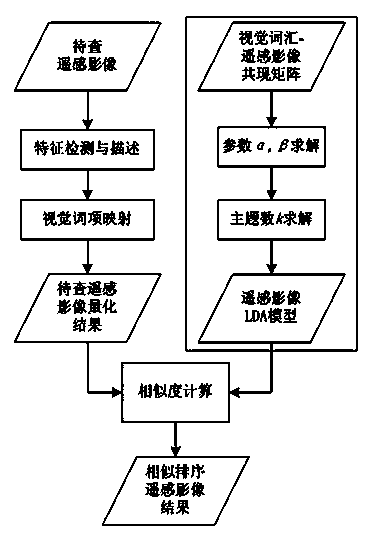
[0065] In order to verify that the present invention has better dimensionality reduction effect and higher retrieval accuracy, high-resolution remote sensing image retrieval experiments based on latent semantic analysis and latent Dirichlet allocation were carried out on the established high-resolution remote sensing image database. . The retrieval advantage of implicit Dirichlet distribution is verified by adjusting the dimensionality reduction dimension and the number of topics in the two models.


PUM


Abstract

The invention discloses a retrieval method of remote sensing images. The method includes acquiring and preprocessing the remote sensing images; then detecting and describing bottom visual features, and clustering to generate visual vocabularies; performing remote sensing information retrieval on the basis of a hidden dirichlet distribution model; finally implementing highly-accurate ground feature retrieval. The retrieval method of the remote sensing images has the advantages that fine dimension reduction effect is provided, retrieval accuracy is higher, and a retrieval map can be marked accurately.

Description

technical field [0001] The invention relates to a remote sensing image retrieval method, in particular to a fast and high-resolution remote sensing information retrieval method based on Latent Dirichlet Allocation (LDA), which belongs to the field of remote sensing. Background technique [0002] In recent years, various sensors have been collecting remote sensing images with various temporal, spatial and spectral resolutions all the time, resulting in remote sensing data that grows geometrically. But in fact, the utilization rate of multi-source massive remote sensing data is still low, and the information obtained and used from remote sensing data is not enough to meet the needs of various applications. In terms of storage and management of massive remote sensing data, remote sensing data distribution and sharing websites such as NASA's WIST, USGS, Geospatial One-Stop, EU's INSPIRE, eoPortal, and my country's Earth System Science Data Sharing Network still use centralized d...

Claims


Application Information

Patent Timeline
Patent Type & Authority Applications(China)
IPC IPC(8): G06F17/30G06K9/46
CPCG06F16/583G06F18/23
Inventor 张彤沈盛彧
Owner KUNSHAN HONGHU INFORMATION TECH SERVICE
Why Eureka
Try Eureka