
Method for monitoring water and soil conservation condition based on three-dimensional laser scanning technology

A technology of three-dimensional laser and scanning technology, which is applied in the monitoring field of soil and water conservation based on three-dimensional laser scanning technology, can solve the problems of not being able to adapt to the automatic development trend of soil and water conservation monitoring, not satisfying rapid monitoring, and low work efficiency, so as to improve monitoring Efficiency, fast sampling rate, and cost-saving effects

Inactive Publication Date: 2014-12-03
POWERCHINA CHENGDU ENG
View PDF2 Cites 21 Cited by
  • Summary
  • Abstract
  • Description
  • Claims
  • Application Information

AI Technical Summary

Problems solved by technology

Several monitoring methods proposed in the current "Technical Regulations for Soil and Water Conservation Monitoring", such as community observation, control station observation, simple slope measurement method, survey monitoring method, and remote sensing monitoring method, are relatively backward and have low work efficiency, which can no longer meet the needs of rapid monitoring. needs, and cannot adapt to the development trend of soil and water conservation monitoring automation

Method used


Image

  • Method for monitoring water and soil conservation condition based on three-dimensional laser scanning technology

Examples


Embodiment Construction

[0021] The invention aims to propose a method for monitoring soil and water conservation based on three-dimensional laser scanning technology, so as to realize efficient and accurate monitoring of soil and water conservation.

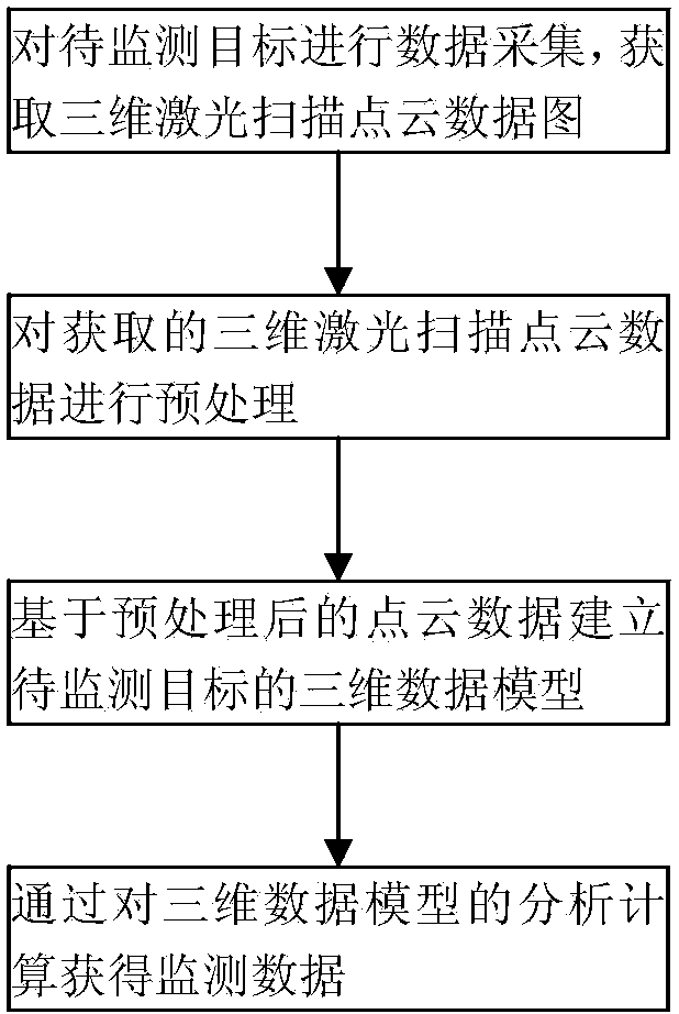
[0022] Such as figure 1 As shown, the method for monitoring soil and water conservation based on three-dimensional laser scanning technology in the present invention includes the following implementation steps:

[0023] a. Use a 3D laser scanner as a data collection tool to collect data from the target to be monitored and obtain a 3D laser scanning point cloud data map;

[0024] b. Preprocessing the acquired 3D laser scanning point cloud data;

[0025] c. Establish a 3D data model of the target to be monitored based on the preprocessed 3D laser scanning point cloud data;

[0026] d. Obtain monitoring data through the analysis and calculation of the three-dimensional data model.

[0027] The scheme of the present invention is further described with a ...


PUM


Abstract

The invention relates to a geology monitoring technology, and discloses a method for monitoring the water and soil conservation condition based on the three-dimensional laser scanning technology. The water and soil conservation condition can be efficiently and accurately monitored through the method. The method comprises the following steps of a, with a three-dimensional laser scanner as a data collection tool, carrying out data collection on a target to be monitored and acquiring a three-dimensional laser scanning point cloud data map; b, preprocessing acquired three-dimensional laser scanning point cloud data; c, establishing a three-dimensional data model of the target to be monitored based on the preprocessed three-dimensional laser scanning point cloud data; d, acquiring monitoring data through analytical calculation of the three-dimensional data model. The method is suitable for efficiently and accurately monitoring the water and soil conservation condition.

Description

technical field [0001] The present invention relates to geological monitoring technology, specifically, it relates to a monitoring method for soil and water conservation based on three-dimensional laser scanning technology, through the three-dimensional data collection and model reconstruction of the monitoring target, quantitative monitoring data is obtained for evaluating monitoring The target water and soil loss status and the implementation of water and soil conservation measures. Background technique [0002] Soil and water conservation monitoring refers to the long-term investigation, observation and analysis of the occurrence, development, hazards and benefits of soil and water conservation. Through soil and water conservation monitoring, find out the types, intensity and distribution characteristics of water and soil loss, hazards and their impact, occurrence and development rules, and dynamic trends, and make macro decisions on comprehensive control of water and soi...

Claims


Application Information

Patent Timeline
IPC IPC(8): G01S17/89G06F19/00
CPCG01S17/89G01S7/4802
Inventor 詹晓敏孙大东魏凡秦甦戴松晨
Owner POWERCHINA CHENGDU ENG
Learn More