Polar inertial navigation method based on horizontal wandering coordinate system

An inertial navigation and coordinate system technology, applied in the field of inertial navigation, can solve the problems of complex transformation of physical platforms, complex transformation of coordinate system parameters, complex switching logic, etc., to meet navigation requirements, solve the problem of inapplicability in polar regions, reduce The effect of heading

Active Publication Date: 2014-12-17
SOUTHEAST UNIV
View PDF3 Cites 18 Cited by
  • Summary
  • Abstract
  • Description
  • Claims
  • Application Information

AI Technical Summary

Problems solved by technology

[0003] Technical problem to be solved: Aiming at the deficiencies of the prior art, the present invention proposes a polar area inertial navigation method based on a lateral wandering coordinate system, which is used to solve the complex logic of switching between regions of different latitudes existing in the existing inertial navigation system. Many inconvenient technical problems such as complex coordinate system parameter conversion and physical platform conversion

Method used


Image

  • Polar inertial navigation method based on horizontal wandering coordinate system
  • Polar inertial navigation method based on horizontal wandering coordinate system
  • Polar inertial navigation method based on horizontal wandering coordinate system

Examples


Embodiment Construction

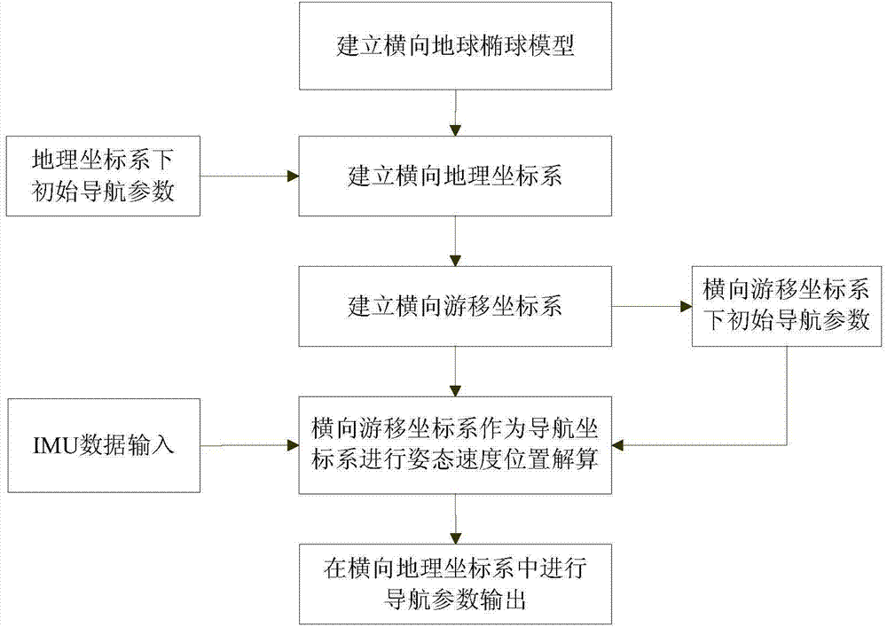
[0069] The present invention will be further described below in conjunction with the accompanying drawings.

[0070] Such as figure 1 Shown is the schematic diagram of the method of the present invention.

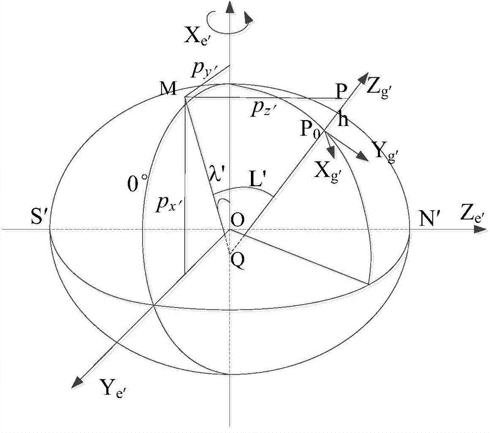
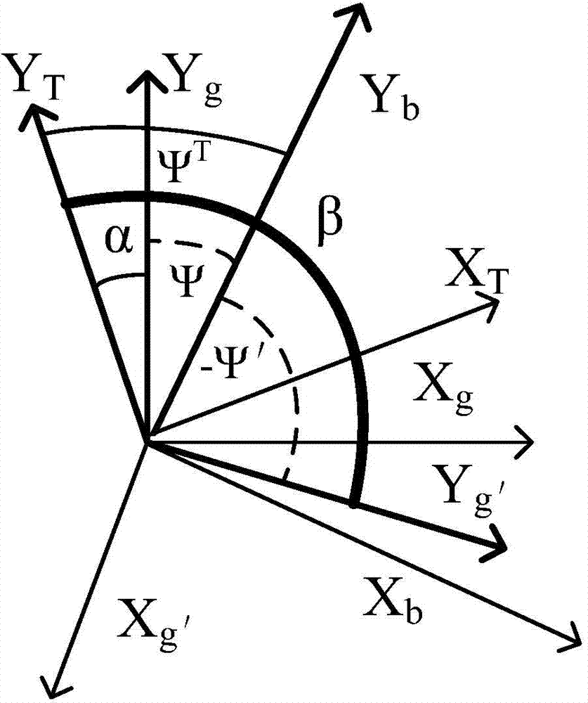
[0071] First establish the horizontal ellipsoidal model and on this basis establish the horizontal ellipsoidal coordinate system e′, the horizontal geographic latitude and longitude and the horizontal geographic coordinate system g′, and then establish the horizontal wandering coordinate system T based on the horizontal geographic coordinate system g′, the specific position relationship like figure 2 shown; image 3 The relationship between the angles involved in the present invention is given, X T Axis, Y T The axes are the two axes in the lateral movement coordinate system T, X b Axis, Y b The axes are respectively the horizontal axis (pointing to the right) and the vertical axis (pointing to the front) of the body coordinate system b, X g′ Axis, Y g′ The axes ar...


PUM


Abstract

The invention discloses a polar inertial navigation method based on a horizontal wandering coordinate system. The method includes the steps: building a horizontal earth ellipsoid coordinate system, a horizontal geographic coordinate system and the horizontal wandering coordinate system, setting a traditional geographic coordinate system of initial navigation time as an initial horizontal wandering coordinate system and performing mechanical layout by taking the horizontal wandering coordinate system as a navigation coordinate system of a strap-down inertial navigation system; solving the problem of strap-down algorithm failure based on the geographic coordinate system due to meridian convergence in polar regions based on the inertial navigation layout mode of the horizontal wandering coordinate system. Besides, mechanical layout is performed in wandering azimuth at low latitudes, the internal integrity of a global navigation resolving algorithm is ensured by combining the modes, switching logic design of different latitudes and the transformational relationship between parameters of different navigation coordinate systems are avoided in the strap-down inertial navigation system, and complicated physical platform switching is avoided in a platform inertial navigation system.

Description

technical field [0001] The present invention mainly relates to the technical field of inertial navigation, in particular to an inertial navigation method based on a lateral wandering coordinate system. Background technique [0002] Traditional inertial navigation theories are designed for low-latitude regions. In reality, it can generally work normally in areas with a latitude less than 65 degrees; near the South Pole and the North Pole, due to the distribution characteristics of latitude and longitude, traditional inertial navigation theories and methods have certain defects. When the traditional inertial navigation machinery under the geographic coordinate system g navigates in polar regions, the heading angle error and longitude error increase sharply with the increase of latitude, which can no longer meet the needs of navigation. Some literatures propose to establish a horizontal earth model and use the horizontal geographic coordinate system g' for navigation, which ca...

Claims


Application Information

Patent Timeline
Patent Type & Authority Applications(China)
IPC IPC(8): G01C21/16
CPCG01C21/16
Inventor 徐晓苏姚逸卿
Owner SOUTHEAST UNIV
Why Eureka
Try Eureka