Satellite positioning and static leveling-based layered settlement monitoring system and method

A layered settlement and static leveling technology, applied in the direction of hydrostatic pressure, etc., can solve the problems of lower efficiency, inability to realize automation and real-time monitoring, and difficulty in establishing the working base point in a stable area.

Active Publication Date: 2015-01-21
CHINA JK INST OF ENG INVESTIGATION & DESIGN
View PDF7 Cites 26 Cited by
  • Summary
  • Abstract
  • Description
  • Claims
  • Application Information

AI Technical Summary

Problems solved by technology

The static leveling system can directly obtain the differential settlement of each monitoring point. If it is necessary to obtain the absolute settlement of each measuring point, it is necessary to establish a stable working base point. Large-area filling sites, large-scale landslides, underground mined-out areas, etc., it is difficult to build the working base point in

Method used


Image

  • Satellite positioning and static leveling-based layered settlement monitoring system and method
  • Satellite positioning and static leveling-based layered settlement monitoring system and method
  • Satellite positioning and static leveling-based layered settlement monitoring system and method

Examples


Embodiment Construction

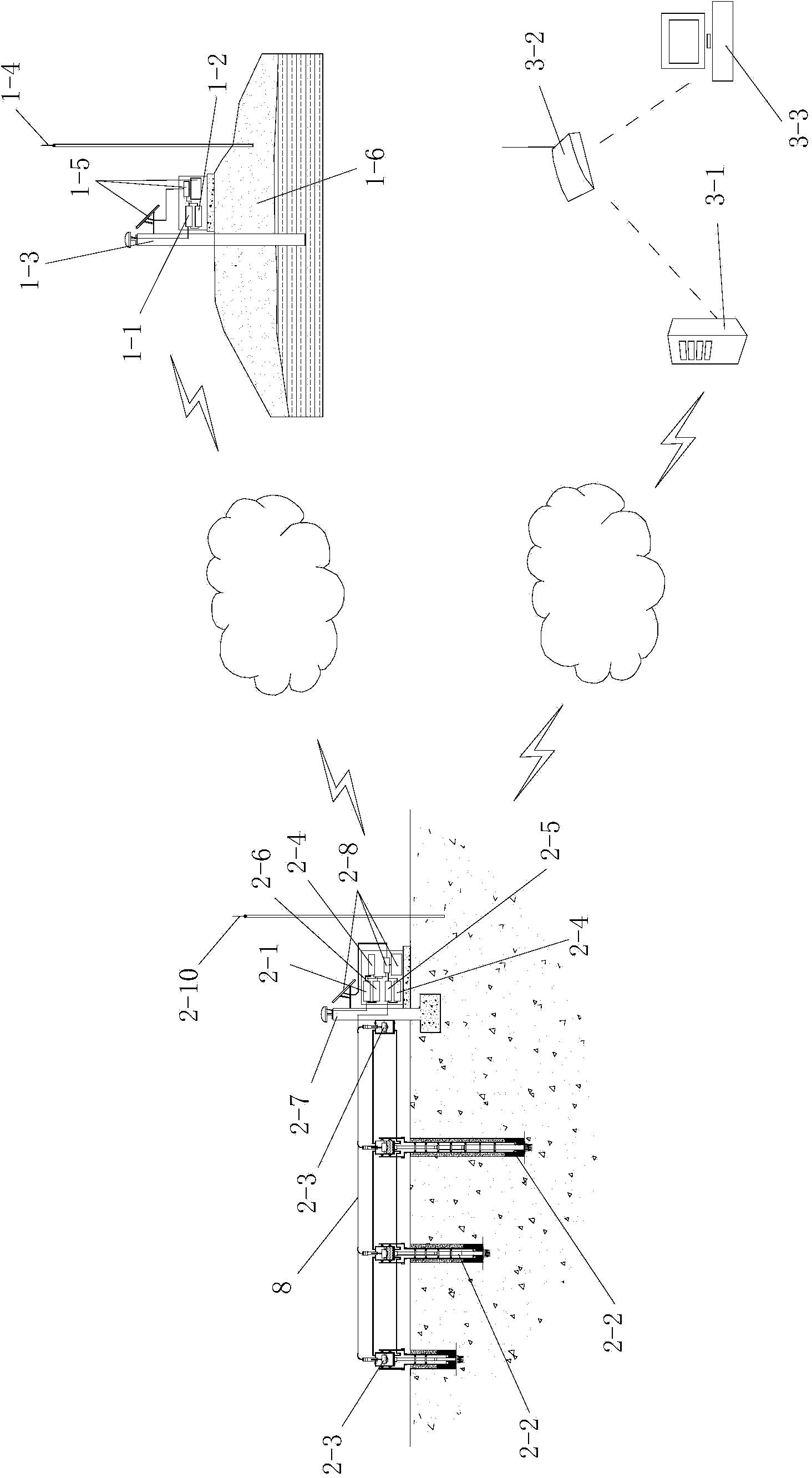
[0066] Such as figure 1 A layered subsidence monitoring system based on satellite positioning and static leveling is shown, including a reference station arranged on the ground, a monitoring station arranged in the subsidence monitoring area, and a wireless communication system that communicates with the monitoring station. In the monitoring center, the reference station communicates with the monitoring station in a wireless communication manner.

[0067] The reference station is a Beidou satellite ground base station, and it includes a first Beidou satellite signal receiver 1-1 and a first wireless communication device 1-2 connected with the first Beidou satellite signal receiver 1-1.

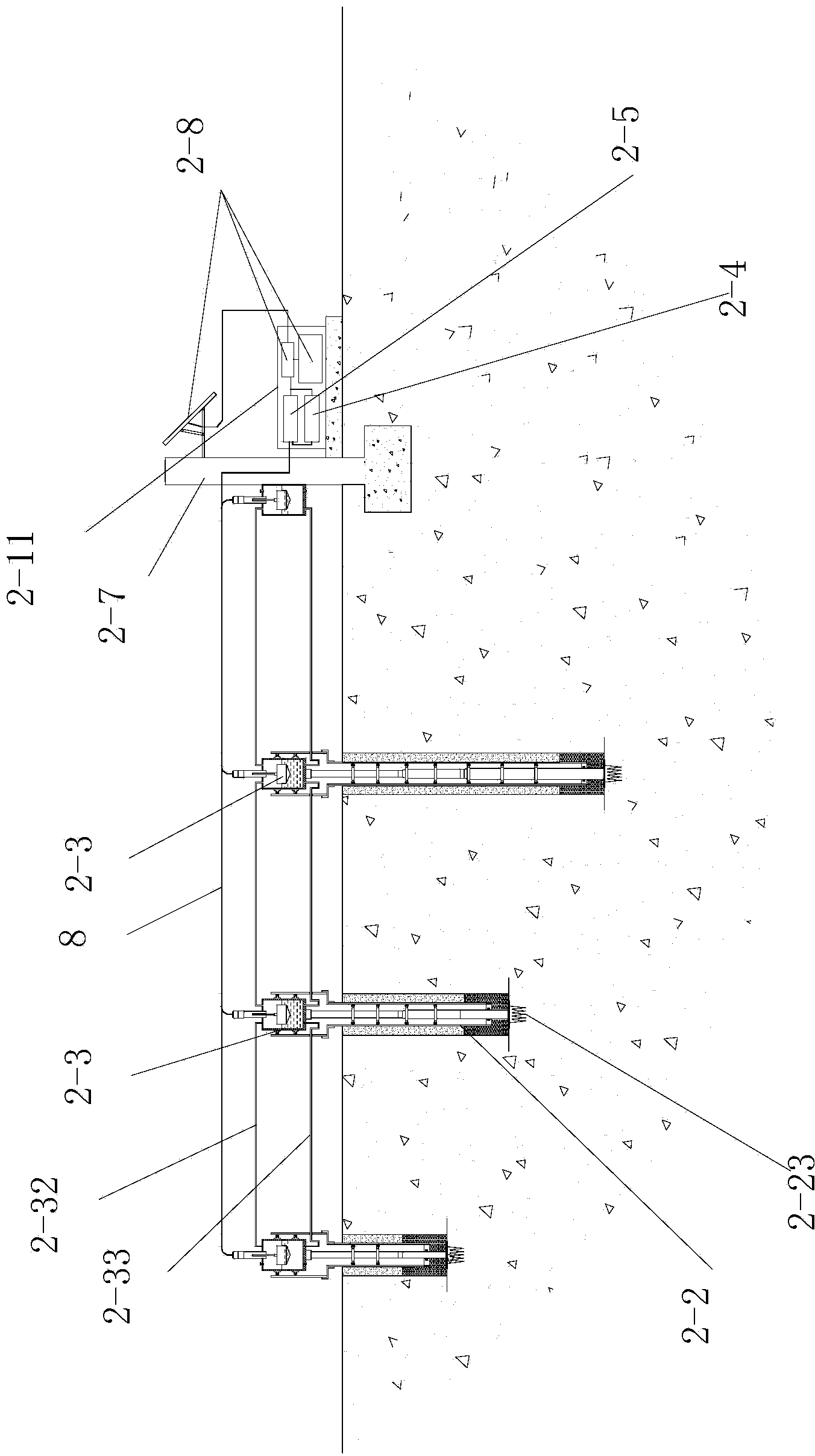
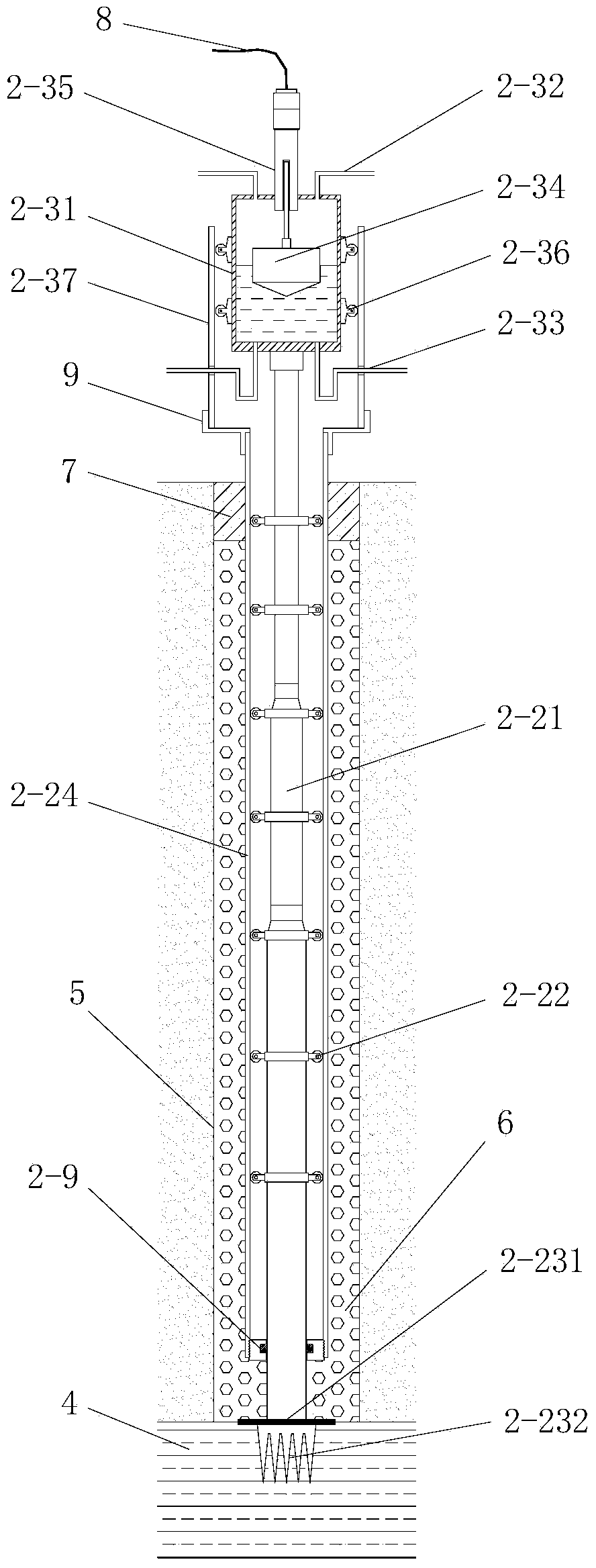
[0068] The monitoring station includes a second Beidou satellite signal receiver 2-1, a data transmission unit 2-4, a second wireless communication device 2-6, and a plurality of layered subsidence marks 2-1 respectively buried in the subsidence monitoring area. 2 and a static leveling system...


PUM

PropertyMeasurementUnit
Diameteraaaaaaaaaa

Abstract

The invention discloses a satellite positioning and static leveling-based layered settlement monitoring system and method. The system comprises a base station, a monitoring station which is arranged in a settlement monitoring area and a monitoring center which communicates with the monitoring station, wherein the base station communicates with the monitoring station; the monitoring station comprises an observation pillar, a second Beidou satellite signal receiver mounted on the observation pillar, a data transmission unit, a plurality of layered settlement marks and a static level system; the static level system comprises a plurality of static level gauges; each layered settlement mark is provided with one static level gauge; one of the static level gauges is arranged on the observation pillar. The method comprises the following steps: I, setting of the monitoring system; II, data acquisition and transmission; III, data processing and analysis. According to the satellite positioning and static leveling-based layered settlement monitoring system and method, the calibration and correction problems of the instable working base points during the static leveling can be effectively solved, and the long-term, remote and real-time monitoring for the layered settlement deformation of the geologic bodies can be realized.

Description

technical field [0001] The invention belongs to the technical field of geotechnical engineering monitoring, and in particular relates to a layered settlement monitoring system and method based on satellite positioning and static leveling. Background technique [0002] In highways, railways, airports, docks, dams and other projects, in order to grasp the effective compression layer thickness of the foundation soil and the deformation characteristics of each layer of soil within the compression layer range, study the development law and stability of foundation deformation, and carry out engineering safety warnings, etc. , it is often necessary to monitor the layered settlement of the soil. [0003] At present, there are mainly two monitoring methods commonly used in engineering for soil layer settlement: First, the electromagnetic settlement method: the casing is buried vertically at the monitoring position in the stratum of the monitoring site, and the outer wall of the casin...

Claims


Application Information

Patent Timeline
IPC IPC(8): G01C5/04
CPCG01C5/04
Inventor 于永堂张继文郑建国刘争宏张炜杜伟飞李攀刘智羊群芳戚长军
Owner CHINA JK INST OF ENG INVESTIGATION & DESIGN
Why Eureka
Try Eureka