Storage method and device for laser radar point cloud data

A technology of laser point cloud data and point cloud data, which is applied in image data processing, electrical digital data processing, special data processing applications, etc., can solve problems such as unfavorable data processing and point cloud disorder, and achieve the effect of improving efficiency

Active Publication Date: 2015-03-11
PETROCHINA CO LTD
View PDF4 Cites 18 Cited by
  • Summary
  • Abstract
  • Description
  • Claims
  • Application Information

AI Technical Summary

Problems solved by technology

[0003] At present, the ground-based 3D laser scanning system mostly uses line scanning to collect data, and adopts row-by-row or column-by-column scanning to collect data. The collected 3D laser point cloud data has a certain structural relationship. Most of the storage methods for 3D laser point cloud data only divide the massive point cloud into pyramid blocks. lack any topological relationship between them, so this method is not conducive to the subsequent data processing

Method used


Image

  • Storage method and device for laser radar point cloud data
  • Storage method and device for laser radar point cloud data
  • Storage method and device for laser radar point cloud data

Examples


Embodiment 1

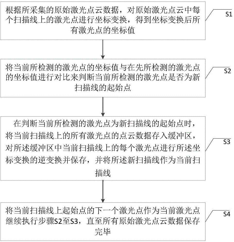
[0066] figure 2 It is a schematic flow chart of the storage method of laser radar point cloud data in this embodiment. The storage method is aimed at collecting the three-dimensional coordinate points of ground objects in a row-by-row or column-by-column scanning mode by the ground three-dimensional laser scanning system. These three-dimensional coordinates The points are spatially arranged in the form of a line scan point cloud, and the storage method includes the following steps:

[0067] Step S101 , according to the collected original laser point cloud data, perform coordinate transformation on the laser points on each scanning line in the original laser point cloud, and obtain the coordinate value of each laser point after the coordinate transformation.

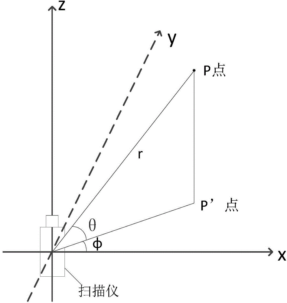
[0068] In this embodiment, since the coordinates of the laser points on each scanning line in the collected original laser point cloud are three-dimensional rectangular coordinates (x, y, z), it is preferable to use the ...

Embodiment 2

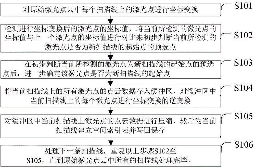
[0104] The embodiment of the present application also provides a storage device for lidar point cloud data, such as Figure 7 As shown, the storage device includes: a coordinate transformation unit 201 , a detection and judgment unit 202 , a cache unit 203 and a storage unit 204 . Wherein, the coordinate transformation unit 201 is configured to perform coordinate transformation on the laser points on each scanning line in the original laser point cloud according to the collected original laser point cloud data, and obtain coordinate values ​​of all laser points after coordinate transformation. The coordinate transformation unit 201 also includes a coordinate transformation subunit 2011, which is used to convert the three-dimensional rectangular coordinates (x, y, z) of each laser point in the original laser point cloud data into three-dimensional laser scanning The spherical coordinates (r, θ, φ) of the center of the scanner, where r is the distance from the laser point to the...


PUM


Abstract

The invention discloses a storage method and device for laser radar point cloud data. The storage method comprises the following steps that the coordinate transformation is carried out on each laser point in the original laser point cloud data; each laser point after the coordinate transformation is detected, whether the currently detected laser point is a starting point of a new scanning line is judged by using the change of a laser point coordinate value; when the condition that the currently scanned laser is the starting point of the newly scanned line is judged, the laser point cloud data on a former scanning line is stored into a buffer region, and the coordinate reverse transformation is carried out on each laser point of the former scanning line in the buffer region; a space index is built for the affiliated scanning line of the laser point subjected to the coordinate reverse transformation, and is stored; the next scanning line is processed, and the steps are repeated until the laser point cloud data on all scanning lines is completely stored. The device mainly comprises a coordinate transformation unit, a detection judgment unit, a cache unit and a storage unit. Through the technical scheme, the subsequent data processing efficiency can be improved.

Description

technical field [0001] The present application relates to the field of lidar data processing, in particular to a method and device for storing lidar point cloud data. Background technique [0002] Three-dimensional laser scanning technology (Light Detection And Ranging, LiDAR) is an advanced automatic high-precision three-dimensional scanning technology. This technology originated from the research and development of NASA in 1970 and developed rapidly in the 1980s. It also set off a research upsurge in 3D laser scanning technology, with more and more scanning objects and wider and wider application fields. According to the division of 3D laser scanning system based on the carrying platform, it can be divided into airborne 3D laser scanning system, vehicle 3D laser scanning system and ground 3D laser scanning system. Among them, the 3D ground laser scanning system is mainly for 3D modeling and reconstruction of high-precision reverse engineering. Accurately collected into t...

Claims


Application Information

Patent Timeline
Patent Type & Authority Applications(China)
IPC IPC(8): G06F17/30G06T1/60
CPCG06T1/60G06T3/604
Inventor 谢兴曾齐红叶勇刘松张友焱胡艳张强马志国于世勇申晋利邢学文
Owner PETROCHINA CO LTD
Why Eureka
Try Eureka