Multilayer cloud real-time ranging method

A distance measuring method and a timer technology, which are applied in measuring devices, radio wave measuring systems, electromagnetic wave re-radiation, etc., can solve the problems of high cost of unit devices and high overall cost

Active Publication Date: 2016-12-28
STATE GRID CORP OF CHINA +1
View PDF4 Cites 0 Cited by
  • Summary
  • Abstract
  • Description
  • Claims
  • Application Information

AI Technical Summary

Problems solved by technology

However, this technology not only needs to ensure the penetration and detection capabilities of the laser, but also needs to measure the atmospheric layers, resulting in high cost of the unit device adopted. At the same time, more protection measures are taken to ensure the performance of the instrument in the field, so the overall cost is relatively high. High, the accuracy depends not only on the composition of the hardware system but also on the accuracy of the algorithm

Method used


Image

  • Multilayer cloud real-time ranging method

Examples


Embodiment Construction

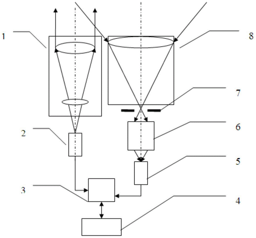
[0026] figure 1 It is a multilayer cloud real-time ranging device, which consists of a laser beam expanding and shaping system 1, an infrared laser diode 2, a signal recognition timer 3, a system control module 4, a photoelectric detector 5, a subsequent optical path 6, a small hole aperture 7, and a receiving telescope 8 composition.

[0027] The laser beam expansion and shaping system 1 is arranged in front of the infrared laser diode 2 , and the infrared laser diode 2 is connected to a signal recognition timer 3 . The signal recognition timer 3 is connected with the photodetector 5, and the photodetector 5 is connected with the subsequent optical path 6, and the front of the subsequent optical path 6 is successively provided with an aperture aperture 7 and a receiving telescope 8. The laser beam expanding and shaping system 1 is composed of a plurality of adjustable lenses. The system control module 4 includes a communication interface for connecting with a host computer....


PUM


Abstract

The invention discloses a multilayer cloud real-time distance measurement device and a distance measurement method thereof. The multilayer cloud real-time distance measurement device comprises a laser beam expanding and shaping system, an infrared laser diode, a signal identification timer, a system control module, a photoelectric detector, a subsequent light path, a small hole diaphragm and a receiving telescope; the laser beam expanding and shaping system is arranged in front of the infrared laser diode, and the infrared laser diode is connected to the signal identification timer; the signal identification timer is connected with the photoelectric detector, the photoelectric detector is connected with the subsequent light path, and the small hole diaphragm and the receiving telescope are arranged in front of the subsequent light path in sequence; the laser beam expanding and shaping system is formed by combination of a plurality of adjustable lenses; and the system control module includes a communication interface used for being connected with an upper computer. According to the multilayer cloud real-time distance measurement device provided by the invention, an efficient optical transmitting and receiving system and a simple low-cost distance measurement identification circuit are adopted, the multilayer cloud-base height can be measured, and the multilayer cloud real-time distance measurement device can automatically work all the time in an unattended manner.

Description

technical field [0001] The invention relates to a multilayer cloud real-time ranging method. Background technique [0002] Instruments used for cloud base height measurement often use ranging principles and meter scattering lidar remote sensing principles. [0003] Instruments that use the principle of distance measurement include cloud curtain lights, laser ranging ceilometers, etc. The measurement accuracy of cloud curtain lights is too low, so they are basically no longer used now. Laser ranging ceilometers use laser pulses to be sent to the clouds, and Record the emission time and the time of the light pulse signal reflected by the cloud base, and calculate the distance through the time. Due to the structure adopted and the light source used are not strong in the atmosphere, and the receiving ability of the detection unit is not high, generally during the day It is only 1-2 kilometers, and it is only 8 kilometers at night, and the technical route of timing is only recor...

Claims


Application Information

Patent Timeline
Patent Type & Authority Patents(China)
IPC IPC(8): G01S17/08
CPCG01S17/08
Inventor 孙雪清孔洁程琳程雪
Owner STATE GRID CORP OF CHINA
Why Eureka
Try Eureka