Grassland productivity estimation method based on remote sensing and GIS (geographic information system)

A combination of productivity and technology, applied in the field of grassland productivity estimation, can solve the problems of difficult, laborious and time-consuming grassland productivity

Inactive Publication Date: 2015-03-25
NORTHEAST INST OF GEOGRAPHY & AGRIECOLOGY C A S
View PDF3 Cites 28 Cited by
  • Summary
  • Abstract
  • Description
  • Claims
  • Application Information

AI Technical Summary

Problems solved by technology

[0004] The present invention aims to solve the shortcomings of the traditional method of estimating grassland productivity, which is time-consuming, laborious, and difficult to achieve large-scale and long-term continuous acquisition, and provides a method for estimating grassland productivity based on the combination of remote sensing and GIS

Method used


Image

  • Grassland productivity estimation method based on remote sensing and GIS (geographic information system)
  • Grassland productivity estimation method based on remote sensing and GIS (geographic information system)
  • Grassland productivity estimation method based on remote sensing and GIS (geographic information system)

Examples


specific Embodiment approach 1

[0017] Specific implementation mode 1: The grassland productivity estimation method based on the combination of remote sensing and GIS in this embodiment is implemented in the following steps:

[0018] Step 1: Preprocessing the original grassland data:

[0019] Unify the original grassland data under the same coordinate system and projection; where the projection is Albers projection, the same coordinate system uses 105° east longitude, and the grassland raw data includes grass productivity data, vegetation index data, and grass spatial distribution data And land use data;

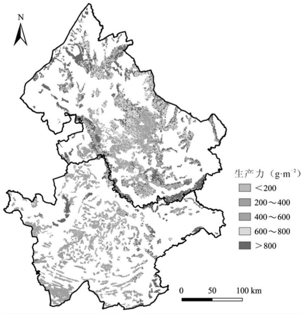
[0020] Step 2: Select the normalized vegetation index NDVI, the ratio vegetation index RVI, the modified soil adjustment vegetation index MSAVI and the enhanced vegetation index EVI to construct a multi-vegetation index-based multi-type grassland productivity estimation model;

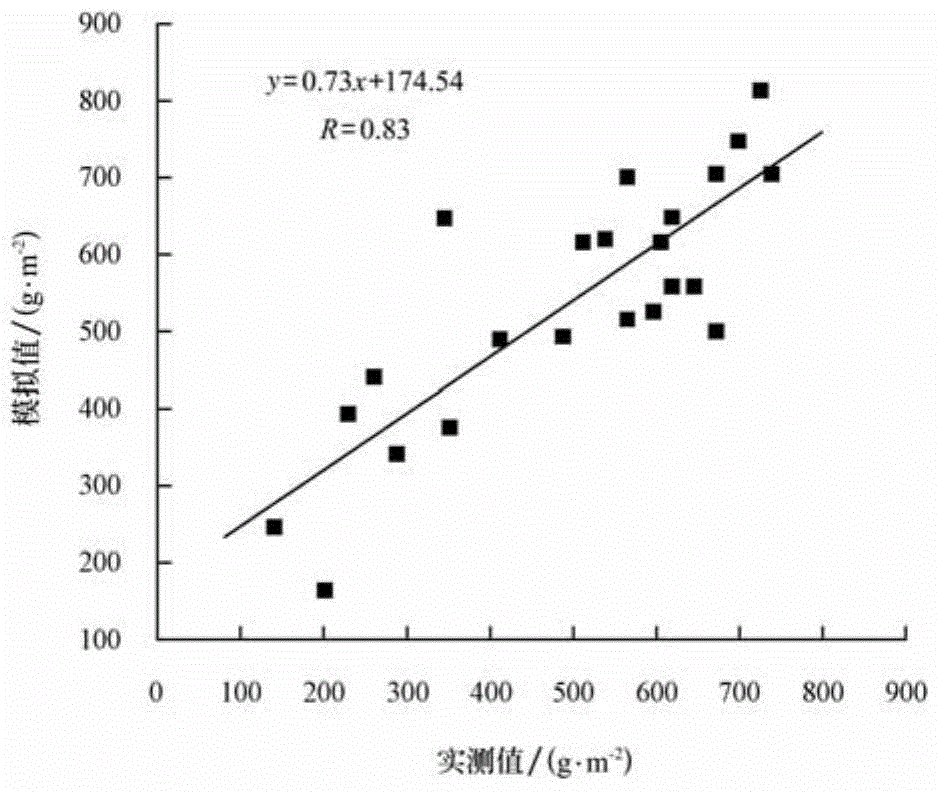
[0021] Step 3. Use the field-measured grassland productivity data in the same period to verify the accuracy of the multi-type grassland p...

specific Embodiment approach 2

[0026] Specific implementation manner 2: This implementation manner is different from specific implementation manner one in that the specific process of obtaining grassland productivity data in the first step is:

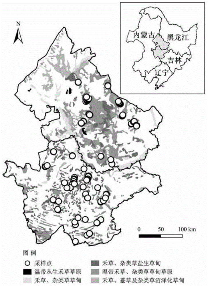
[0027] Collect the grassland biomass during the period of maximum grass productivity in the field, and record the location of sampling points with GPS. Set 3 or 5 small squares as repeats in each 10m×10m sample plot, collect the green part of each small square on the ground, and dry it at 65℃ to balance weight. The biomass of all small squares in each sample plot The average value is the aboveground biomass of each sample. According to the ratio of grassland belowground biomass to aboveground biomass (root / shoot ratio), the total grassland biomass is obtained; through the conversion coefficient of biomass and carbon, grassland productivity data is obtained.

[0028] Other steps and parameters are the same as in the first embodiment.

specific Embodiment approach 3

[0029] Specific embodiment three: This embodiment is different from specific embodiment one or two in:

[0030] 1. NDVI and EVI come from the MOD13Q1 vegetation index data set developed by NASA (National Aeronautics and Space Administration) / MODIS (Moderate Resolution Imaging Spectroradiometer) based on a unified algorithm (download URL: https: / / wist.echo.nasa.gov) ), RVI and MSAVI are calculated by using the reflectance data of the red and near-infrared bands in the vegetation index data set, see formulas (1), (2), (3), (4) for details:

[0031] NDVI = ρ NIR - ρ R ρ NIR + ρ R - - - ( 1 )

[0032] EVI = 2.5 ( ρ NIR - ρ R ) ρ NIR + 6.0 ρ R - 7.5 ρ B + 1 - - - ( 2 )

[0033] RVI = ρ NIR ρ R - - - ( 3 )

[0034] MSAVI = 0.5 X [ 2 ρ NIR + 1 - ( 2 ρ NIR + 1 ) 2 - 8 ...


PUM


Abstract

The invention relates to a grassland productivity estimation method based on remote sensing and a GIS (geographic information system). The method solves the defects that the traditional method is time-consuming and labor-consuming when estimating grassland productivity, and difficultly realizes large-range and long-term continuous acquisition. The method comprises the steps of: Step I, preprocessing grassland raw data, Step II, selecting an NDVI (normalized difference vegetation index), an RVI (ratio vegetation index), an MSAVI (modified soil adjusted vegetation index) and an EVI (enhanced vegetation index) to construct various grassland productivity estimation models based on the vegetation indices, Step III, selecting the optimal grassland productivity estimation model, Step IV, making grid operation by using the optimal grassland productivity estimation model and the vegetation indices to obtain a grassland productivity spatial distribution chart, estimating total grassland productivity according to total grassland area, and Step V, establishing a grassland productivity prediction model by taking the vegetation indices as independent variables and the grassland productivity in a future certain period as a dependent variable. The method is applied to the field of ecology and the remote sensing.

Description

Technical field [0001] The invention relates to a grassland productivity estimation method based on the combination of remote sensing and GIS. Background technique [0002] In recent years, the instability of the ecological environment due to the development of human society has increased significantly, which has caused a series of ecological and environmental problems, such as the serious degradation of grassland quality and the sharp decline of livestock carrying capacity due to excessive reclamation and grazing in pursuit of economic benefits. Problems such as increasingly severe soil erosion and damage to biodiversity. Therefore, rapid assessment of the current situation of grassland and accurate prediction of future development trends are of far-reaching significance for guiding the scientific and rational use of regional grassland. [0003] The rapid development of remote sensing and GIS technology provides a good method for studying various ecological and environmental prob...

Claims


Application Information

Patent Timeline
Patent Type & Authority Applications(China)
IPC IPC(8): G06F19/00
Inventor 罗玲王宗明毛德华
Owner NORTHEAST INST OF GEOGRAPHY & AGRIECOLOGY C A S
Why Eureka
Try Eureka