A method for superimposing virtual reality on airborne graphic images

A technology of graphic image and superimposition method, which is applied in the direction of image communication, TV, color TV parts, etc., can solve the problems that the natural fusion of graphics and images cannot be achieved, and the texture information of graphics and images is not considered, so as to improve the situation and space perception ability and the effect of improving flight safety performance

Active Publication Date: 2017-10-20
AVIC NO 631 RES INST
View PDF10 Cites 0 Cited by
  • Summary
  • Abstract
  • Description
  • Claims
  • Application Information

AI Technical Summary

Problems solved by technology

The above three methods are all rigid overlays. They do not consider the unique texture information of graphics and images, and cannot achieve natural fusion of graphics and images.

Method used


Image

  • A method for superimposing virtual reality on airborne graphic images

Examples


Embodiment Construction

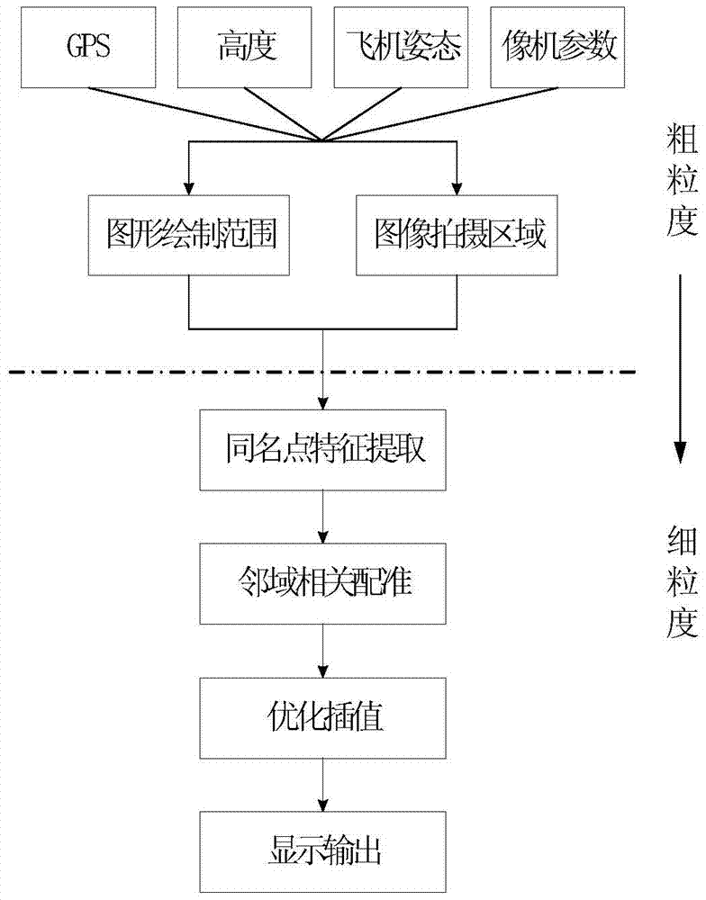
[0019] Such as figure 1 As shown, the airborne graphic image virtual and real superposition method is divided into two parts: coarse-grained processing and fine-grained processing;

[0020] In the coarse-grained processing part: firstly, using the airborne GPS information, altitude information, aircraft attitude (pitch, roll, yaw) information, camera parameters (focal length, placement degrees of freedom) information, through spatial geometry three-dimensional coordinate transformation and The computer vision affine transformation equation quickly locates the shooting area of ​​the video image; and then uses this as a reference to read the same position and the same area range in the onboard database (in practical applications, this area range is larger than the area of ​​the video image captured by the camera) The elevation data and topographical landform data are drawn by the computer to generate corresponding graphics, and the observation angle is adjusted to be consistent ...


PUM


Abstract

The present invention is an efficient and high-precision superposition method of airborne graphics and images, and on the basis of fully considering the data texture information, the natural fusion of two types of data, namely, graphics and images, is realized. The method is divided into two stages of coarse-grained processing and fine-grained processing. In the coarse-grained processing stage, the relevant information of the real-time state is collected to quickly locate the shooting area of ​​the video image; Equipped with the elevation data and topographic data of the area, the corresponding graphics are generated by computer drawing, and the viewing angle of view is adjusted to be consistent with the viewing angle of the camera; in the fine-grained processing stage, the feature detection algorithm is first used to extract the features of the same name of the graphics and images. information to achieve high-precision registration of graphics and images; with the help of optimized interpolation algorithm, graphics and image data are fused, that is, the results of virtual and real superposition of output graphics and images are displayed.

Description

technical field [0001] The invention belongs to the field of airborne graphics and image processing, and relates to a virtual and real superimposition method of airborne graphics and images. Background technique [0002] The Enhanced Synthetic Vision System (ESVS), also known as the Enhanced Flight Vision System (EFVS), will provide a visual scene that is more in line with the observation mechanism of the human eye. visual information and prompts. It combines the advantages of Enhanced Vision System (EVS) and Synthetic Vision System (SVS), and its focus is to solve the problem of virtual and real superposition of graphics and images. [0003] There are three traditional superimposition methods of virtual and real graphics images: (1) fixed-position window superimposition, that is: a display window with a constant size is opened at a certain fixed position on the display interface to display video images; (2) background full-window superposition, namely : Cover the entire d...

Claims


Application Information

Patent Timeline
Patent Type & Authority Patents(China)
IPC IPC(8): H04N5/232H04N5/262
Inventor 文鹏程牛文生谢建春程岳
Owner AVIC NO 631 RES INST
Why Eureka
Try Eureka