Orthographic correction method of CCD image of HJ-1 satellite

An orthorectification and image technology, which is applied in the field of image processing, can solve the problems of not being suitable for HJ satellite images and HJ satellite images without strict models, and achieve the effect of avoiding oscillation, good confidentiality, and uniform distribution of fitting errors

Active Publication Date: 2015-04-22
CHINA CENT FOR RESOURCES SATELLITE DATA & APPL
View PDF9 Cites 6 Cited by
  • Summary
  • Abstract
  • Description
  • Claims
  • Application Information

AI Technical Summary

Problems solved by technology

However, the HJ satellite image distributed by the HJ satellite image supplier does not have a strict model, so the

Method used


Image

  • Orthographic correction method of CCD image of HJ-1 satellite
  • Orthographic correction method of CCD image of HJ-1 satellite
  • Orthographic correction method of CCD image of HJ-1 satellite

Examples


Embodiment

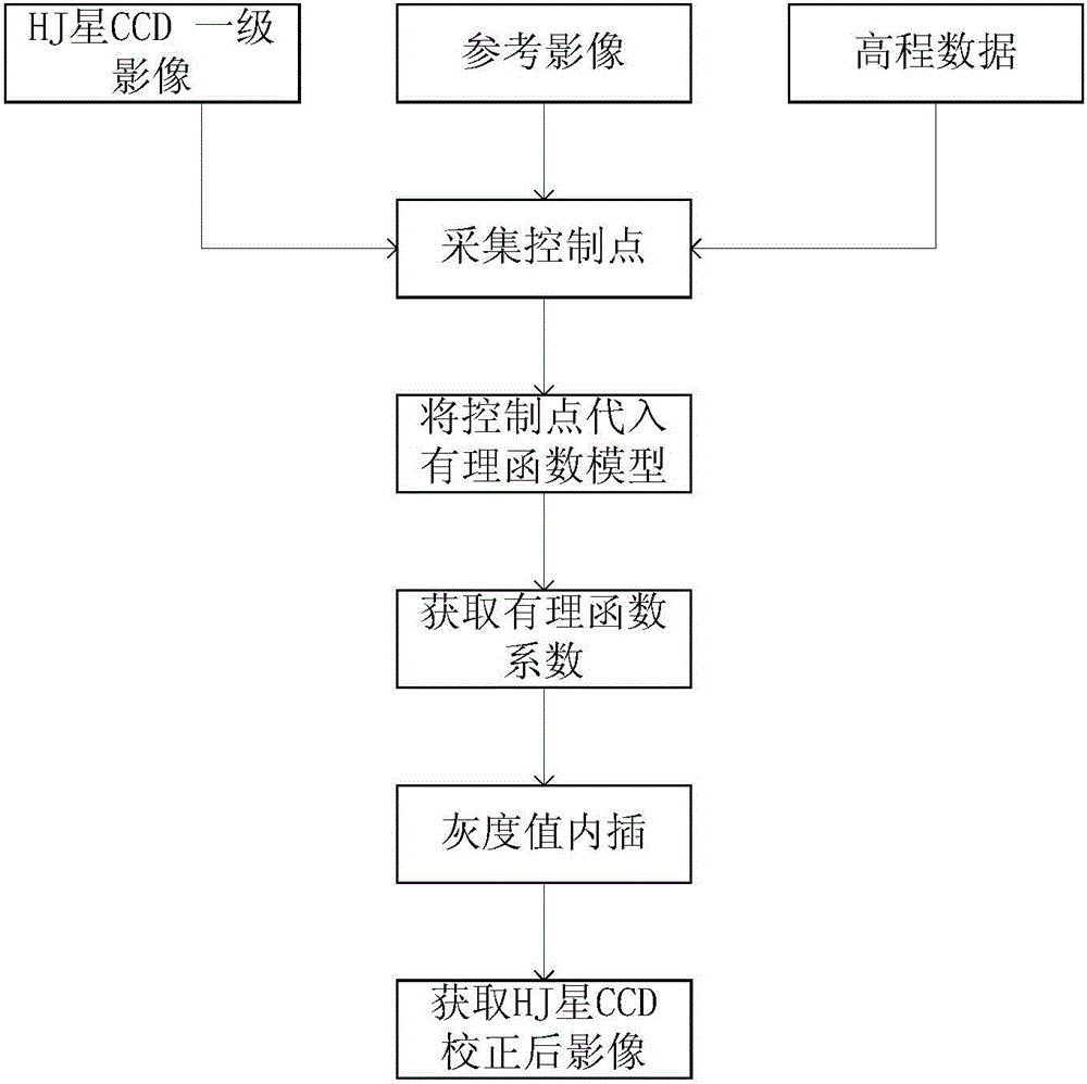
[0044]1. Import the HJ star CCD primary image with the file name HJ1A-CCD1-8-84-20130414.

[0045] 2. Import the elevation data and reference data of Environment-1 satellite. The quality of the elevation data and reference data directly affects the accuracy of the orthophoto results. The selection principle is that the grid spacing of the elevation data should not be greater than five times the resolution of the CCD image of the HJ star. Not less than the resolution of the CCD image of the HJ star. The resolution of the reference data should not be greater than or less than four times the resolution of the CCD image of the HJ star. The elevation data used in this example is the 90-meter grid spacing SRTM (Space Shuttle Radar Topographic Mapping Mission) released by NASA, and the reference data is the 15-meter resolution LandSat (Land Satellite) released by NASA Panchromatic ortho data.

[0046] 3. Evenly collect 81 ground control points on the HJ1A-CCD1-8-84-20130414 image an...


PUM


Abstract

The invention relates to an orthographic correction method of a CCD image of an HJ-1 satellite. A first-stage image of a CCD of an HJ satellite as well as corresponding altitude data and reference data are introduced; ground control points are collectedly uniformly at the first-stage image of the CCD of the HJ satellite; coordinates of the collected control points are introduced into a cubic rational function model and calculation is carried out to obtain a rational polynomial coefficient (RPC), so that a corresponding rational function model is obtained; pixel coordinates of all points of the first-stage image of the CCD of the HJ-1 satellite are inputted into the rational function model to obtain coordinates corresponding to all points of an image after orthographic correction; and with a bilinear interpolation method, interpolation of gray values of all points of the image after correction is carried out on points with pixel coordinates in an entire row or column mode, thereby obtaining an orthographic correction image. According to the invention, compared with the traditional polynomial method, the provided orthographic correction method enables the precision to be improved.

Description

technical field [0001] The invention relates to a method for orthorectifying a CCD image, in particular to a method for orthorectifying an image of a CCD sensor of the Environment-1 satellite, which is suitable for the orthorectification of the CCD image of the Environment-1 satellite and belongs to the technical field of image processing. Background technique [0002] Satellites A and B of Environment-1 were launched in Taiyuan on September 6, 2008. The two satellites A and B are each equipped with two CCD cameras with a resolution of 30 meters and a width of 360 kilometers. The two-star collaboration can achieve a two-day return cycle. Due to its high time resolution, good macroscopic properties, and multi-scale characteristics, the satellite has broad application prospects in environmental and disaster monitoring and assessment. [0003] The HJ star CCD image covers about 360 kilometers, and its huge width leads to serious geometric distortion of the HJ CCD image. From ...

Claims


Application Information

Patent Timeline
IPC IPC(8): G06T5/00
Inventor 黄世存韩启金曾湧潘志强王奇
Owner CHINA CENT FOR RESOURCES SATELLITE DATA & APPL
Why Eureka
Try Eureka