Terrestrial latitude measuring instrument

A measuring instrument and latitude technology, applied in theodolite, measuring device, measuring angle and other directions, can solve the problems of inability to judge and measure the shadow length of the pole, the operation process is not convenient enough, the shadow length of the pole, etc., and achieve accurate and effective measurement results , high promotional value and low production cost

Inactive Publication Date: 2015-06-03
XIAN LIANKONG ELECTRICAL
View PDF0 Cites 0 Cited by
  • Summary
  • Abstract
  • Description
  • Claims
  • Application Information

AI Technical Summary

Problems solved by technology

[0002] At present, the teaching textbook introduces the method of measuring and calculating the local latitude by using the vertical pole measurement shadow algorithm. This method needs to measure the length of the vertical pole and the length of the shadow, and the result can only be obtained through trigonometric function calculations. The operation process is not convenient enough, and Due to human reasons, there will be a lot

Method used


Image

  • Terrestrial latitude measuring instrument
  • Terrestrial latitude measuring instrument

Examples


Embodiment Construction

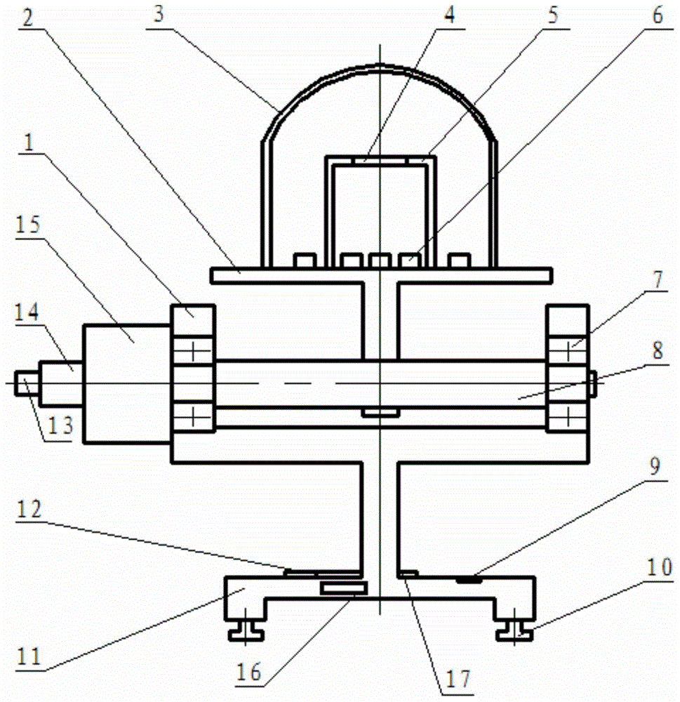
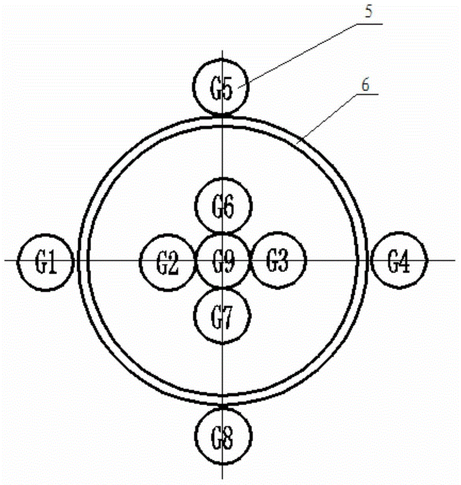
[0022] Such as figure 1 , figure 2 As shown, the present invention includes a support frame 1, a rotary table 2, a motor 14, a horizontal shaft 8 and a base 11 fixedly connected with the support frame 1, and the two ends of the horizontal shaft 8 are respectively connected to the support frame 8 through bearings 7. 1, the output shaft of the motor 14 is connected with a reducer 15, the reducer 15 is fixedly connected to the outside of one end of the support frame 1, the output shaft of the reducer 15 is fixedly connected with the horizontal shaft 8, and the motor 14 is provided with a useful For the angle encoder 13 that records the rotation angle of the motor 14, the lower end of the turntable 2 is fixedly connected to the middle of the horizontal shaft 8 and rotates together with the horizontal shaft 8 driven by the motor. The turntable 2 is provided with a shading cylinder 5 and nine Photosensitive element 6, the top of described light-shielding tube 5 is provided with th...


PUM


Abstract

The invention discloses a terrestrial latitude measuring instrument. The instrument comprises a supporting frame, a rotating platform, a motor, a horizontal shaft, and a base which is fixedly connected with the supporting frame, wherein the horizontal shaft is supported on the supporting frame through a bearing; a speed reducer is connected to the motor and fixedly connected to the outer side of one end of the supporting frame; an output shaft of the speed reducer is fixedly connected with the horizontal shaft; an angle coder is arranged on the motor; the rotating platform is fixedly connected with the horizontal shaft; a shading barrel and nine light sensitive elements are arranged on the rotating platform; a through hole is formed in the top end of the shading barrel; a lens is mounted on the through hole; the nine light sensitive elements are distributed at the inside and outside of the shading barrel; a gradienter, a compass and a display are arranged on the base; the angle coder, the light sensitive elements, the motor and the display are all connected with a controller in the base. The instrument is simple in structure, reasonable in design, convenient to mount, fast to measure the local latitude, accurate and effect in measurement result, simple and convenient to operate, good in use effect, and high in popularization value.

Description

technical field [0001] The invention belongs to the field of measuring equipment, in particular to an earth latitude measuring instrument. Background technique [0002] At present, the teaching textbook introduces the method of measuring and calculating the local latitude by using the vertical pole measuring shadow algorithm. This method needs to measure the length of the vertical pole and the length of the shadow, and the result can only be obtained through trigonometric function calculations. The operation process is not convenient enough, and A large error will be caused due to human reasons, and when the sun is very low, the shadow of the pole is too long, and the image is blurred, so it is impossible to judge and measure the length of the shadow of the pole. Using a digital camera to measure latitude at night and using Polaris to measure latitude is very accurate, but the process is very cumbersome, and the latitude positioning is performed with the help of stars in the...

Claims


Application Information

Patent Timeline
IPC IPC(8): G01C1/00
CPCG01C1/02
Inventor 卫荣平
Owner XIAN LIANKONG ELECTRICAL
Why Eureka
Try Eureka