
Autonomous vehicle navigation method for assisting orientation by applying omnimax neutral point

An autonomous navigation, neutral point technology, applied in the field of vehicle navigation, can solve problems such as decreased positioning accuracy, poor two-dimensional heading angle information, and lack of effective suppression.

Inactive Publication Date: 2015-06-17
NANCHANG UNIV
View PDF2 Cites 27 Cited by
  • Summary
  • Abstract
  • Description
  • Claims
  • Application Information

AI Technical Summary

Problems solved by technology

[0003] However, under normal circumstances, the accuracy of the two-dimensional heading angle information obtained by the kinematic model is worse than that of the on-board strapdown inertial navigation system. The error is still not effectively suppressed, and then the positioning accuracy will gradually decrease

Method used


Image

  • Autonomous vehicle navigation method for assisting orientation by applying omnimax neutral point
  • Autonomous vehicle navigation method for assisting orientation by applying omnimax neutral point
  • Autonomous vehicle navigation method for assisting orientation by applying omnimax neutral point

Examples


Embodiment Construction

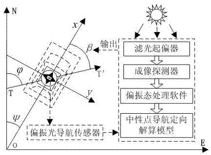
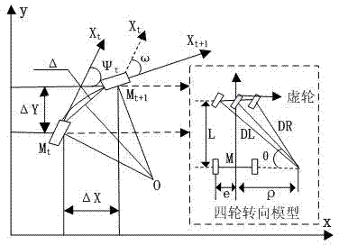
[0059] Attached below Figure 1~4 The present invention is described in detail:

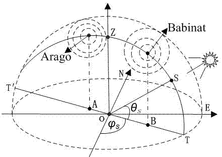
[0060] Atmospheric polarization mode is when sunlight enters the atmosphere and is transmitted through particles such as air molecules and aerosols in the atmosphere, it interacts with matter and undergoes scattering. The scattered light is described by the degree of polarization and polarization direction, and a three-dimensional coordinate system in space is established. , a certain position at a certain time on a certain day, the position of the sun is known, and the sky has a relatively stable and regular polarization distribution pattern. Under ideal weather conditions, the macroscopic and easy-to-measure Stokes vector is used to represent the image of the whole sky image Polarization state, such as figure 1 As shown, O is the carrier observation point, and its corresponding zenith point is Z, TT′ is the projection of the sun’s meridian in the coordinate system, S is the projection point of...


PUM


Abstract

The invention relates to an autonomous vehicle navigation method for assisting orientation by applying an omnimax neutral point. The method comprises the following steps: establishing a vehicle-mounted neutral point navigation orientation model, establishing an improved dynamic mathematical model of a vehicle, establishing a vehicle-mounted polarized light navigation / dynamic mathematical model / inertial navigation combined navigation system, establishing a vehicle-mounted combined navigation system state equation and establishing a vehicle-mounted combined navigation system measuring equation. According to the invention, atmospheric polarization characteristics, inertial navigation and vehicle dynamics / kinematics models are effectively combined, through research on an information fusion scheme and an information fusion method, a reasonable combination scheme is provided, the problem of atmospheric polarization navigation in vehicle-mounted application is solved, a passive navigation system with high autonomy, good hidden property and anti-interference is constructed, and precise reliable autonomous navigation positioning of a land fighting vehicle can be wholly realized.

Description

technical field [0001] The invention belongs to the technical field of vehicle navigation, and relates to the use of a neutral point under the full-sky atmospheric polarization mode to perform angle measurement and orientation so as to improve the performance of a kinematic model-assisted inertial navigation system, and constructs a vehicle-mounted polarized light navigation / kinematics / inertial integrated navigation System, suitable for autonomous navigation of vehicles. Background technique [0002] In view of the problem that the active navigation wave of land combat vehicles is susceptible to interference and failure in special warfare environments, autonomous passive navigation and positioning technology is the key to ensure that the carrier can perform reliable high-precision navigation and positioning in this background. In recent years, domestic and foreign researchers have aimed at the performance limitations of a single autonomous passive navigation and positioning ...

Claims


Application Information

Patent Timeline
IPC IPC(8): G01C21/16G01C21/20
CPCG01C21/16G01C21/20
Inventor 熊剑王吉旭杨祖华郭杭马号林舟杰周先赞徐江颖杨欢
Owner NANCHANG UNIV
Learn More