Data fusion method used for multi-frequency multichannel ground penetrating radar

A ground-penetrating radar and data fusion technology, which is applied in the field of exploration geophysical data processing, can solve the problems of inconvenient interpretation of detection results, and achieve an effect that is conducive to interpretation and identification of abnormalities

Inactive Publication Date: 2015-07-22
CENT SOUTH UNIV
View PDF5 Cites 17 Cited by
  • Summary
  • Abstract
  • Description
  • Claims
  • Application Information

AI Technical Summary

Problems solved by technology

For this reason, the multi-frequency and multi-channel ground-penetrating radar system was developed and used for railway subgrade detection (Liu Jie et al., Using ground-penetrating radar technology to evaluate the current situation and development of existing railway subgrade conditions, Railway Construction, No. 1, 200

Method used


Image

  • Data fusion method used for multi-frequency multichannel ground penetrating radar
  • Data fusion method used for multi-frequency multichannel ground penetrating radar
  • Data fusion method used for multi-frequency multichannel ground penetrating radar

Examples


Embodiment Construction

[0031] The present invention will be further described below in conjunction with the accompanying drawings and embodiments.

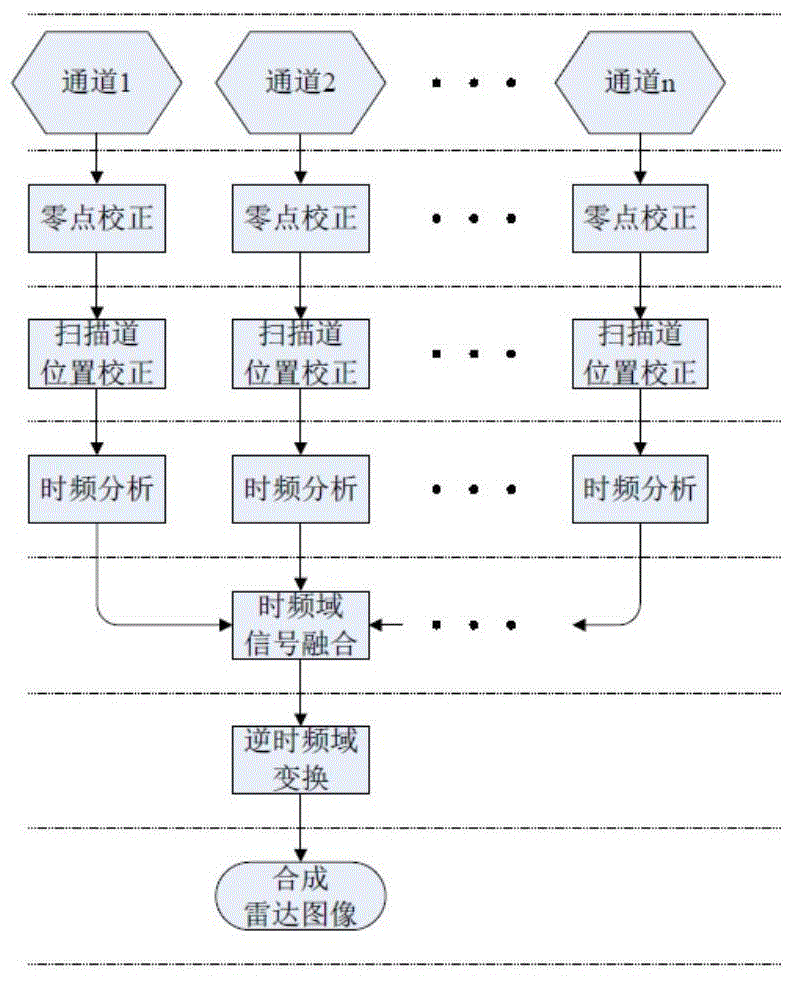
[0032] A data fusion method for multi-frequency multi-channel ground penetrating radar, such as figure 1 shown, including the following steps:

[0033] Step 1: Obtain multi-channel radar profiles with different center frequencies;

[0034] Step 2: Correct the zero point of the scan track and the measured position of the scan track for the radar profile of each channel;

[0035] The zero-point correction of the scanning track refers to intercepting each scanning track of the radar signal of each channel to complete the zero-point correction by identifying the direct wave and taking the direct wave as a reference;

[0036] The correcting of the measured position of the scanning track refers to taking the maximum scanning number in all channels as a benchmark, and realizing the position correction of the scanning track through an interpolation method, so...


PUM


Abstract

The invention discloses a data fusion method used for a multi-frequency multichannel ground penetrating radar. As for original continuous section scanning data of the multi-frequency multichannel ground penetrating radar, the data of each channel are subjected to scanning channel zero correction and scanning channel actual measurement position correction to obtain multi-frequency multichannel radar data of corresponding positions in a scanning section; the radar scanning channel data of each channel at the corresponding position are subjected to time-frequency analysis to obtain multichannel radar signals in a time-frequency domain; the corresponding radar scanning signals of different channels are subjected to synthesis in the time-frequency domain to obtain time-frequency domain radar data, synthesized by the radar scanning signals of the different channels, for each scanning channel position; the synthesized time-frequency domain radar data are subjected to inverse time-frequency transform according to the scanning channels sequentially to obtain a time-domain multi-frequency fusion radar image. The data fusion method has the advantages that the data of the multi-frequency multi-channel ground penetrating radar can be fused effectively, and prospecting capabilities with larger prospecting depth and higher resolution ratio can be achieved by means of making full use of the multi-frequency multi-channel radar signals.

Description

technical field [0001] The invention belongs to the field of geophysical data processing for exploration, and relates to a data fusion method for multi-frequency and multi-channel ground penetrating radar. Background technique [0002] As an efficient non-destructive testing technology, ground penetrating radar is widely used in engineering exploration, concrete component defects, road surface detection, and roadbed disease detection, and has achieved good detection results. Usually, if you need to get high-resolution detection results, you need to use a radar system with a higher center frequency, but a shallower detection depth. If a larger exploration depth is required, a radar system with a lower center frequency is selected, but the resolution is lower. [0003] However, the two performance indicators of ground penetrating radar, detection resolution and exploration depth, cannot be balanced with the requirements of practical applications. For example, with the increa...

Claims


Application Information

Patent Timeline
IPC IPC(8): G01S13/88G01S13/89
CPCG01S13/885G01S13/89
Inventor 肖建平王韵棋柳建新吴旭东胡章棚
Owner CENT SOUTH UNIV
Why Eureka
Try Eureka