UAV and LiDAR integrated forest stand characteristic inversion method

A stand feature and inversion technology, applied in 3D modeling, image data processing, instruments, etc., can solve the problems of high cost of lidar data and difficulty in wide application.

Active Publication Date: 2015-08-26
NANJING FORESTRY UNIV
View PDF7 Cites 28 Cited by
  • Summary
  • Abstract
  • Description
  • Claims
  • Application Information

AI Technical Summary

Problems solved by technology

However, the cost of lidar data is high, and it is diff

Method used


Image

  • UAV and LiDAR integrated forest stand characteristic inversion method
  • UAV and LiDAR integrated forest stand characteristic inversion method
  • UAV and LiDAR integrated forest stand characteristic inversion method

Examples


Embodiment 1

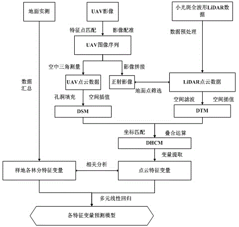
[0047] A forest stand feature inversion method integrating UAV and LIDAR, based on the understory high-precision digital elevation model (DEM) obtained by LiDAR point cloud and the 3D point cloud (DSM) of the upper layer of vegetation canopy constructed by UAV image pair sequence, extracting The characteristic variables related to height and canopy point cloud density and build a forest stand characteristic variable prediction model, the technical process is as follows figure 1 As shown, the specific process is as follows:

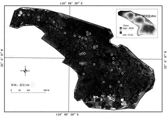
[0048] Niushan, the research area, is located in the Zijin Mountain in the eastern suburbs of Nanjing City, Jiangsu Province, with the geographical coordinates of the center (118°48'E, 32°04'N), and a total area of ​​13.90hm 2 , the elevation range is 16-40m. It has a north subtropical monsoon climate with four distinct seasons and an average annual rainfall of 1005.9mm. The main forest type is the northern subtropical evergreen and deciduous broad-leave...


PUM


Abstract

The invention a UAV and LiDAR integrated forest stand characteristic inversion method. UAV data is combined with LiDAR data to extract typical forest stand characteristic, a 3D point cloud, which is generated by utilizing a feature point matching algorithm and aerotriangulation, of a research region serves as a digital surface model, a crown canopy model is calculated by combining the digital surface model with a digital terrain model extracted by LiDAR, a multiple regression estimation model is established by combining practically measured forest stand investigation data of the ground and the extracted point cloud variable, and the precision of the multiple regression estimation model is verified. Canopy cloud point uses UAV data, and compared with LiDAR data, the flexibility is high, the cost is low, data is convenient to obtain, and the data can be observed in a long-term set-time repeated manner; terrain data is obtained by utilizing the penetrability of LiDAR, and the terrain is relatively stable, and can be used as basis of long-term observation data. UAV is combined with LiDAR, advantages of the two are used, and the forest state monitoring manner is cheap and flexible; and related analysis shows that cloud point variable and forest vertical information (the height of trees) which are extracted in a combined manner are highly sensitive.

Description

technical field [0001] The invention relates to the technical field of forest resource management and protection, in particular to a forest stand feature inversion method integrating UAV and LIDAR. Background technique [0002] Accurate determination of stand characteristic variables such as stand average height, average diameter at breast height, stand density, and stock volume is of great significance for forest management and ecological monitoring. The traditional measurement method is manual on-site measurement, which is time-consuming and labor-intensive and can only obtain small-area data, making it difficult to obtain regional or larger-scale information. The remote sensing method can quickly obtain the state of a large area of ​​forest, reduce the consumption of manpower and material resources, and has high accuracy in data integrity and timeliness. However, the optical remote sensing data mainly records the horizontal structure information of the forest, and its re...

Claims


Application Information

Patent Timeline
IPC IPC(8): G06T17/00
Inventor 许子乾曹林阮宏华李卫正蒋圣
Owner NANJING FORESTRY UNIV
Why Eureka
Try Eureka