Multi-dimension aviation remote sensing test platform

An aerial remote sensing and testing platform technology, which is applied to measuring devices, surveying and navigation, three-dimensional position/channel control, etc., can solve the problems of only collecting remote sensing data in low-altitude areas, operability remote sensing equipment cannot return safely, etc., to achieve Achieve real-time transmission and processing, low power consumption, and fast response

Active Publication Date: 2015-09-02
BEIHANG UNIV
View PDF4 Cites 22 Cited by
  • Summary
  • Abstract
  • Description
  • Claims
  • Application Information

AI Technical Summary

Problems solved by technology

[0003] The technical problem of the present invention is to overcome the shortcomings of existing remote sensing drones that can only collect remote sensing data in low-altitude areas, to make up for the deficiencies in mobility and operability of remote sensing balloons, airships, etc., and in most cases, remote sensing equipment cannot be safe Returning to the defects on the ground, using remote sensing balloons and UAVs as platforms, integrating various remote sensing test equipment on the servo control platform for synchronous information collection, providing a multi-scale aerial remote sensing test platform, which can be used in about 30 - The 40km-high near-space can acquire large-scale, high-coverage spectral information or images, and can carry out remote sensing measurements with strong mobility and rapid response in low-to-medium altitude areas, and can realize real-time data transmission and processing. The safe return from space to low-altitude areas to the ground can meet the needs of agricultural remote sensing, environmental monitoring, surveying and mapping, security, and fire detection for multi-scale remote sensing

Method used


Image

  • Multi-dimension aviation remote sensing test platform
  • Multi-dimension aviation remote sensing test platform

Examples


Embodiment Construction

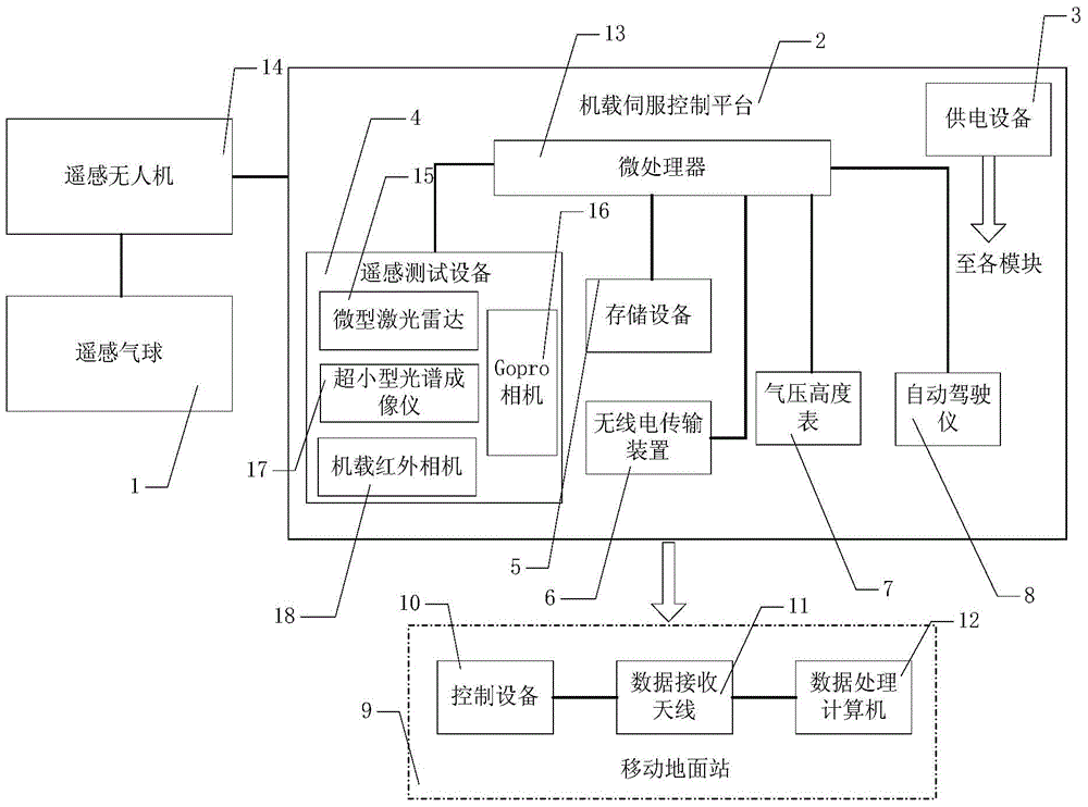
[0017] Such as figure 1Shown is a block diagram of the structure of the present invention, that is, a multi-scale aerial remote sensing test platform, a multi-scale aerial remote sensing test platform, is characterized in that: comprising remote sensing balloon (1), remote sensing unmanned aerial vehicle (14), machine Carrying servo control platform (2) and mobile ground station (9), mobile ground station (9) is made up of control equipment (10), data receiving antenna (11) and data processing computer (12), airborne servo control platform (2 ) consists of microprocessor (13), power supply equipment (3), remote sensing test equipment (4), storage device (5), radio transmission device (6), barometric altimeter (7) and autopilot (8), Among them, the remote sensing test equipment (4) includes a miniature laser radar (15), a Gopro camera (16), an ultra-small spectral imager (17) and an airborne infrared camera (18); a remote sensing balloon (1) and a remote sensing drone ( 14) ar...


PUM


Abstract

The invention relates to a multi-dimension aviation remote sensing test platform. A remote sensing balloon and an unmanned plane are used as platforms; and several kinds of remote sensing testing devices are integrated to a servo control platform in an integrated mode to carry out synchronous information collection. During working, the remote sensing balloon carries the remote sensing unmanned plane to lift off; when arriving at the specified height, the remote sensing balloon and remote sensing unmanned plane are separated from each other; the remote sensing unmanned plane falls at a high speed and enters a gliding mode based on empennage rotation at a low-altitude area; and navigation is carried out by an automatic pilot and thus the plane returns to a specified position. When remote sensing testing equipment works, collected information is stored to storage equipment and is transmitted to a mobile earth station by a radio transmission device to carry out analyses and processing. According to the platform, large-scale high-coverage information can be obtained at high altitudes and remote sensing measurement with high mobility and rapid response can be carried out at middle-altitude and low-altitude areas. Moreover, real-time transmission and processing of data as well as safe equipment return can be realized. Therefore, multi-dimension remote sensing demands of agricultural remote sensing, environment monitoring, plotting, security and protection, and fire detection can be satisfied.

Description

technical field [0001] The invention relates to a multi-scale aerial remote sensing test platform, which uses remote sensing balloons and unmanned aerial vehicles as platforms, and integrates various remote sensing test equipment on the servo control platform for synchronous information collection. Obtain large-scale, high-coverage spectral information or images in the near space, and be able to perform remote sensing measurements with strong mobility and rapid response in the middle and low altitude areas, and realize real-time data transmission and processing, and remote sensing equipment from adjacent space to low-altitude areas The safe return to the ground can meet the needs of agricultural remote sensing, environmental monitoring, surveying and mapping, security, and fire detection for multi-scale remote sensing. Background technique [0002] Remote sensing is an emerging technology developed in the early 1960s. Remote sensing refers to non-contact, long-distance dete...

Claims


Application Information

Patent Timeline
Patent Type & Authority Applications(China)
IPC IPC(8): G05D1/10G01C11/00
Inventor 郭雷齐孟超张霄杨健李晨阳
Owner BEIHANG UNIV
Why Eureka
Try Eureka