Method for performing typhoon location on current satellite image according to history satellite image

A satellite image and typhoon technology, applied in image enhancement, image analysis, image data processing, etc., can solve the problems of high labor intensity of meteorological staff, shorten the time of typhoon positioning, and complicated operation steps, so as to reduce the amount of calculation and shorten the The time, the effect of increasing computational efficiency

Active Publication Date: 2015-10-21
NAT SATELLITE METEOROLOGICAL CENT
View PDF3 Cites 23 Cited by
  • Summary
  • Abstract
  • Description
  • Claims
  • Application Information

AI Technical Summary

Problems solved by technology

[0025] In order to solve the problems of meteorologists with high labor intensity, complex operation steps, and long positioning time in the current method of manually determining the typhoon center, the present invention proposes a typhoon positionin...

Method used


Image

  • Method for performing typhoon location on current satellite image according to history satellite image
  • Method for performing typhoon location on current satellite image according to history satellite image
  • Method for performing typhoon location on current satellite image according to history satellite image

Examples


Embodiment Construction

[0047] The technical scheme of the present invention will be introduced below in conjunction with the accompanying drawings.

[0048] The present invention carries out the method for typhoon positioning on the current satellite image according to the historical satellite image comprising the following steps:

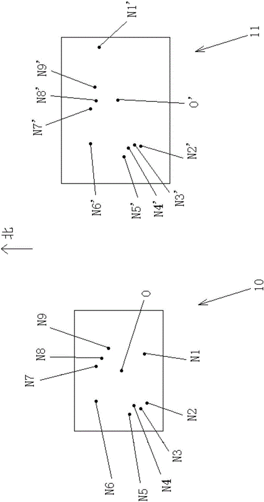
[0049] (1) if figure 1 As shown, take the typhoon center O in the historical satellite images as the center, intercept the picture 10 covering the typhoon cloud system, and extract the scale invariant feature transform (Scale Invariant Feature Transform, hereinafter referred to as SIFT) feature of the picture 10, to obtain the picture Several SIFT feature points of 10, the following is figure 1 A total of 9 SIFT feature points shown in N1-N9 are introduced;

[0050] (2) Intercept the search area 11 on the current satellite image, suppose the time interval between the current satellite image and the historical satellite image is T hours, the resolution of the satellite ...


PUM


Abstract

The invention belongs to the technical field of meteorological prediction. Aiming at solving the problems of the large meteorological staff labor intensity, complex operation steps and long positioning time which exist in a method for determining a typhoon center manually, the invention provides a method for performing typhoon location on a current satellite image according to a history satellite image. The method comprises extracting an SIFT characteristic of the history satellite image, intercepting a search region, a side length of which is L+2*(T*60/P), on the current satellite image, extracting an SIFT characteristic of the search region then, performing characteristic matching on the history satellite image and the search region using an SIFT algorithm, removing a wrong matching relationship based on time-space consistency, performing screening on characteristic points through uniform rotation distribution then, traversing the search region, and determining the typhoon center. Automatic positioning of typhoon is achieved, typhoon positioning steps are simplified, the meteorological staff's workload is reduced, and typhoon positioning time is shortened.

Description

technical field [0001] The invention belongs to the technical field of meteorological prediction, and in particular relates to a method for locating typhoons on current satellite images according to historical satellite images. Background technique [0002] Strictly speaking, a typhoon is a type of intensity of a tropical cyclone. Table 1 shows the classification of tropical cyclones according to their intensity. [0003] Table 1 [0004] intensity name Central wind force (level) Bottom center wind speed (m / s) tropical depression 6~7 10.8~17.1 tropical storm 8~9 17.2~24.4 severe tropical storm 10~11 24.5~32.6 typhoon 12~13 32.7~41.4 strong typhoon 14~15 41.5~50.9 super typhoon 16 >51 [0005] It can be seen from Table 1 that when the central wind force of a tropical cyclone continues to reach level 12-13 and the bottom central wind speed is 32.7-41.4 m / s, it ...

Claims


Application Information

Patent Timeline
IPC IPC(8): G06T7/00G01W1/10
CPCG01W1/10G06T2207/10032G06T2207/30192
Inventor 刘年庆方翔王新廖蜜李云方萌
Owner NAT SATELLITE METEOROLOGICAL CENT
Why Eureka
Try Eureka